Dingle Way - Classic

Duration: 11 days
Trails: T2 trails
Distance: More than 20 km per day
Ascent per day: 250 - 500 m ascent per day
> Walk the full Dingle Way around the Dingle Peninsula
> Accommodation in Tralee before and after the trek is included
> Spend your nights in cozy hotels in traditional towns

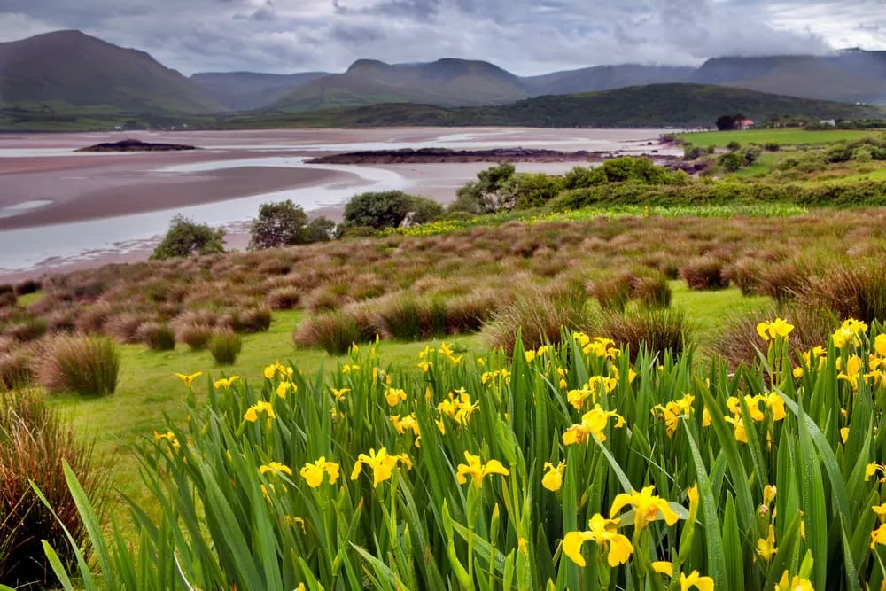
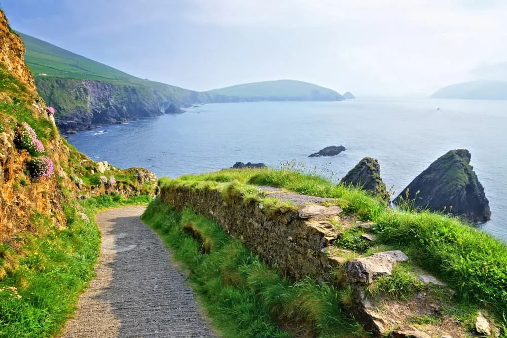
The Dingle Way is an enchanting trek in the Dingle Peninsula, in Ireland. This is a rare slice of Ireland where Gaelige (Gaelic) is still spoken, century-old crofts huddle below the mountains, and where you can find ancient sites scattered across a sparsely populated area. The trek is 179 kilometers long and is traditionally divided into 9 stages. During those stages, you will walk along the coastline and you will enjoy the breathtaking landscapes that this corner of Ireland has to offer.

On this 11-day tour, you will walk along the complete Dingle Way in 9 stages, starting and ending in Tralee. This trek includes accommodation in Tralee before and after your trek so you can plan your trek the previous day and enjoy a well-deserved rest after completing your adventure. We will also arrange the accommodation during the 9 stages of the Dingle Way and we will provide you with the walking notes necessary to complete the circuit. Baggage transfer is also included to make your trek even lighter and more relaxed.

Itinerary

Day
1

Arrival in Tralee

Today you will have to make your way to Tralee. In Tralee, you will spend the night at a hotel preparing for your Dingle Way adventure.

Grand Hotel Tralee (Tralee)

Info
Grand Hotel Tralee (Tralee)
Day
2

Tralee - Camp

Duration: 04:55 h
Distance: 17.8 km
Ascent: 320 m
Descent: 280 m

The Dingle Way trail starts in Tralee. Alongside the railings of the park to the right of the museum you will find the sign marking the official start of the Dingle Way. Across the park, you will find Princes Street. In Princes street turn left and continue to Princes Quay and onto a roundabout. Turn right to start your Dingle Way adventure by following the canal path to Blennerville. Follow the canal path up to the bridge opposite the Blennerville Windmill. Cross the canal towards the village.

The Dingle Way follows the main N86 road to Dingle for a short stretch across Blennerville. After crossing the canal, take the second left turn. Follow some quiet country back roads as you ascend into the flanks of the Slieve Mish mountain range. Follow the trail for about 3 kilometers to Tonavane, where the trail turns west into the open mountainside. Follow the trail across marshy terrain and walk past several breathtaking glacial valleys.

On your way, you will also come across the preserved ruins of Killelton Oratory. The final section of today's stage takes you down to a valley, crosses the Finglas River, and continues uphill towards a minor road. Turn to the right and follow the trail downhill for about 1 kilometer to Camp.

Camp Junction House (Camp)

Info
Camp Junction House (Camp)
Day
3

Camp - Annascaul

Duration: 05:08 h
Distance: 18.2 km
Ascent: 380 m
Descent: 400 m

After Camp, take the trail to the west of the Finglas River crossing. For about 2 km, the Dingle Way guides you towards the southwest while slowly ascending out of the valley. During this section, you can admire the views of the Caherconree Mountain (835m) and the megalithic fort located close to its top. At 235 m you will cross the saddle between the peaks of Corrin and Knockbrack and then you will continue your walk with amazing views of the mountain ridges of Moanlaur and Knockmore to your left.

The path then gradually descends into a small forest, the only one on the entire Dingle Way. You walk through the forest for about 2 kilometers. When you emerge from the forest, follow a minor back road towards the south until the Emlagh River. The Dingle Way then gradually turns to the west and reveals the beautiful views of Inch Beach.

After an energizing break at the beach, continue your walk towards Maum. From the beach, the Dingle Way ascends behind a line of houses facing towards the bay and guides you through small roads away from the coast. After rounding the summit of Knockafeehane you will be able to see the glacial valley on which Lough Annscaul is located. Walk for another 2 kilometers into the heart of Annascaul.

The Old Anchor Inn (Annascaul)

Info
The Old Anchor Inn (Annascaul)
Day
4

Annascaul - Dingle

Duration: 06:29 h
Distance: 23.4 km
Ascent: 400 m
Descent: 430 m

After Annascaul, the Dingle Way joins the busy Tralee-Dingle road for a bit but then turns into a quieter road for 4 kilometers before descending to sea level next to the ruins of the 16th century Minard Castle. After leaving the beach, ascend through a steep, narrow path towards some classic Irish boreens and minor roads that guide you through the surrounding farmland for about 6km. Before Lispole you will find yourself surrounded by breathtaking views of the Croaghskearda (608m) and An Cnapán Mór (649m) peaks to the north. After crossing the N86 road, the Dingle Way heads towards the north in the direction of Croaghskearda Mountain.

Follow the minor road for about 2 kilometers. The path then cuts across farmland and rises onto the lower mountain slopes. This section of the Dingle Way can get quite muddy, so make sure you bring some gaiters along. After crossing the Garfinny River bridge, the Dingle Way heads towards the southwest again towards Dingle.

Dingle Harbour Lodge (Dingle)

Info
Dingle Harbour Lodge (Dingle)
Day
5

Dingle - Dunquin/Ballyferriter

Duration: 05:57 h
Distance: 21.4 km
Ascent: 410 m
Descent: 370 m

Today your day will start walking along the harbor where you will cross the bridge over the Milltown River and you will follow the main road for 1 kilometer. You will then follow a side road towards a rough area of low-lying farmland. Follow this road for about 3 kilometers and then, following the signs, turn to the north and join the "Pilgrim's Route" for 300 meters. The Dingle Way then leaves the "Pilgrim's Route" and turns off the road for 1.5 kilometers across the country towards the northwest. After the Mám an Óraigh saddle, the trail descends onto a minor road that leads to Ventry.

You will then walk for about 2.5 km through the beach across the sands of Ventry Harbour. Once again on firm land, the Dingle Way follows some intertwining minor roads and tracks for about 2 kilometers until meeting the Slea Head Road. Be careful while walking this section alongside the road. A lane to the right will lead you back up to the Dingle Way. You will then walk for 7 kilometers alongside the base of Mount Eagle with amazing views over the Atlantic.

The last part of today's stage guides you once more through the main road for 3km and then descends towards a picturesque and very popular pier, a true symbol of Ireland. The next turn to the right will take you straight to Dunquin.

An Portán Guest House (Dunquin)

Info
An Portán Guest House (Dunquin)
Day
6

Dunquin/Ballyferriter - Ballydavid/Murreagh

Duration: 06:30 h
Distance: 24.5 km
Ascent: 210 m
Descent: 210 m

Today you will start with a brisk ascent out of Dunquin. Heading north the Dingle Way turns into a gravel path and then goes around the shoulder of An Ghráig, situated at 120m above sea level. The route then descends and joins once more the main road.

After walking across grasslands and passing the small Clogher Beach, the Dingle Way skirts some cliffs before arriving on the tarmac, where it proceeds towards the northeast. The trail soon arrives at a T-junction, where there have been some recent changes. Go to the right followed by an immediate turn to the left and walk up the east side of the golf course instead of the west.

After Smerwick Harbour, the Dingle Way will guide you through the beach for about 6 kilometers before reaching Murreagh and Ballydavid. After Ballydavid, you will walk next to the cliffs for about 3 kilometers before heading back inland and rejoining the road at Glashabeg.

An Bothar Pub (Ballydavid)

Info
An Bothar Pub (Ballydavid)
Day
7

Ballydavid/Murreagh - Cloghane

Duration: 06:45 h
Distance: 21.5 km
Ascent: 770 m
Descent: 800 m

During this stage, you will reach the highest point on the Dingle Way. Should the weather conditions be poor and should the visibility be bad, we advise taking a ride to Cloghane.

Today you will leave Ballydavid or Murreagh and you will follow the Dingle Way through an old green road towards the peak Cnoc na mBristi, to the northeast. There follows a long and stiff climb to the shoulder of Brandon Mountain round the saddle between Masatiompan and Piaras Mór. For the descent, the use of walking poles is advised since the path is quite steep and the trails can be muddy. The descent then turns more gradual and guides you into the valley. Walk for another 4 kilometers where you will reach a wider road which will lead you to Brandon Village. The final stage of this section guides you from the pier at Brandon across lanes for just over 6km before finally making it to Cloghane Village.

Mount Brandon Hostel (Cloghane)

Info
Mount Brandon Hostel (Cloghane)
Day
8

Cloghane - Castlegregory/Kilshannig

Duration: 04:19 h
Distance: 16.8 km
Ascent: 70 m
Descent: 70 m
After Cloghane, you follow a quiet, undulating road that turns north after Drom Hill. This section of the Dingle Way is about 3.5 km long before it takes you through Drom and Farrendalouge and rejoins the coast at Fermoyle. The stretch between Fermoyle and Kilshannig is mainly on sandy beaches with several streams to cross. After a day of heavy rain or high tide, these streams can become extremely deep. It is advisable to go to the higher sand dunes, where they are easier to cross.

Harbour House B&B (Castlegregory)

Info
Harbour House B&B (Castlegregory)
Day
9

Castlegregory/Kilshannig - Camp

Duration: 06:01 h
Distance: 23.4 km
Ascent: 120 m
Descent: 70 m
The first part of today's route is mainly along the beach. Then you arrive at Castlegregory. This is a quiet village with a special charm. When leaving Castlegregory, the path goes through a boggy area. At Aughacasla, the path takes you past Tralee Bay, where you have a wonderful view of the water, the beach, and the towering mountains in the distance.

Camp Junction House (Camp)

Info
Camp Junction House (Camp)
Day
10

Camp - Tralee

Duration: 04:52 h
Distance: 18 km
Ascent: 230 m
Descent: 280 m
On the last day of the hike, you cross the Finglas River and head uphill to the valley. You will come across the well-preserved ruins of Killelton Oratory. The trail leads you past some breathtaking glacial valleys and continues over swampy terrain. The path continues into an open mountainside before reaching the Slieve Mish mountain range. You then walk through Blennerville, where you will find the windmill. Then you come to Princes Quay again, with a little further on the Kerry County Museum; the ending point of this walk.

Grand Hotel Tralee (Tralee)

Info
Grand Hotel Tralee (Tralee)
Day
11

Departure

After breakfast, our services and your Dingle Way adventure will be over. Have a safe trip back home!
See entire itinerary

Included

  • Accommodation

    We will arrange your accommodation on the Dingle Way in hotels, inns, and guesthouses. Accommodation will be private in single, double or twin rooms and with en-suite bathroom where possible.

  • Full travel guide

    We will send you on your way with a digital travel guide which includes a route description, interactive Dingle Way hiking maps, and the most important information applicable to your trek.

  • Baggage Transfer

    This trek includes the transfer of your luggage throughout the entire Dingle Way trek. Your bags will be picked up every morning from the hotel lobby and will be driven to your next next accommodation. Baggage transfers allow you to travel lighter during the day and enjoy the walk in a more relaxed manner.

  • Breakfast

    Breakfast is, if possible, included in this trek and it will be provided every morning at your accommodation.

Excluded

  • Traveling to and from

    You have to make your own way to the starting point. The total amount does not include personal transport. This also applies to any transport from the end point of your trail.

  • Transfers

    If you require any form of public or local transport during the trek, it is not included in the package unless stated otherwise. This applies to taxis, buses, cable cars, gondolas, and similar services.

  • Travel Insurance

    Your international travel insurance is your own responsibility. Discuss your itinerary with the insurance company before your trek.

  • Lunch and Dinner

    Breakfast is, if possible, included in the price of the trek. You can get lunch and dinner at the shops, hotels, and restaurants along the way.

FAQ

  • Best Season for the Dingle Way in Ireland

  • How to get to the starting point of the Dingle Way

How to Book

  • Booking

  • Availability

  • Cancellation policy

Reviews

Reviews

Just for You