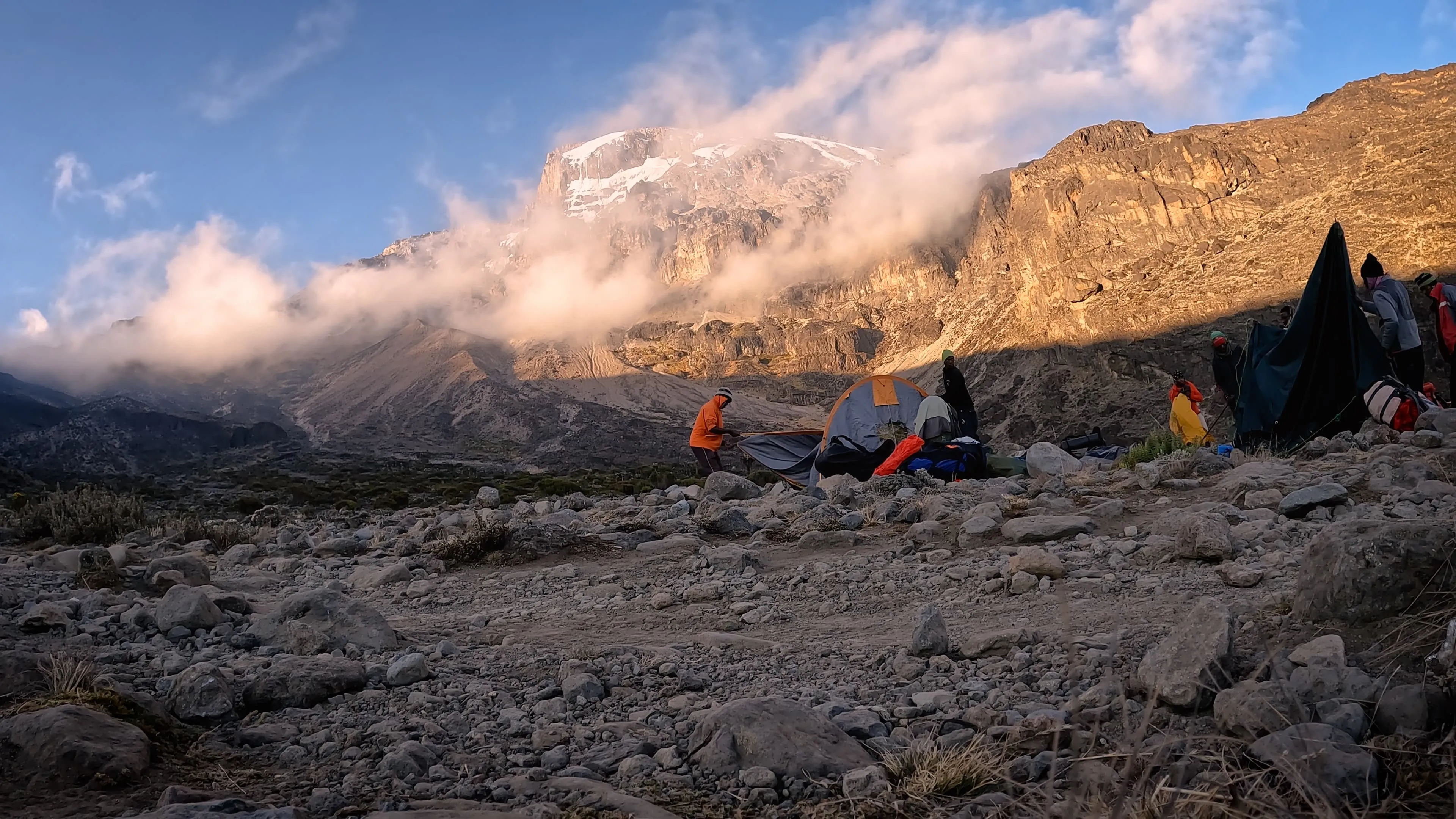
Call us on: +31 850161354
    Languages
  • English
  • Español
  • Deutsch
  • Nederlands
    Currencies
  • € Euro
  • £ British Pound
  • USD $
  • CAD $
  • SEK
  • NOK
  • DKK
  • AUD $
  • CHF
  • NZD $
  • ZAR
  • HK $
  • SGD $
Load more
End of search results

Go back to the Top
No products
FAQ

Frequently Asked Questions

Is The Rongai Route Difficult?

The Rongai Route is usually the first choice in the rainy season. The rainy season lasts from April to May and November to December. The dry season includes January to March and June to October. The Rongai Route isn’t too technical and as such, it is seen as a moderately difficult climbing route. To give you an idea, the route is technically easier than the Lemosho Route, the Northern Circuit and the Machame Route.

It is the only route ascending Mount Kilimanjaro from the North, the Kenyan side of the mountain. Because this is also the quiet side of the mountain, you can get a fairly unspoiled Kilimanjaro experience. It is a lot quieter on the trails and that has its positive impact on the nature and vastness of this side of the mountain.

Is the Rongai Route difficult? The only thing that doesn’t speak for the Rongai Route is the fact that it is a pretty flat route. This means that you can not really climb high and sleep low. Other than that, the Rongai Route is one of the easier options and considering its favorable climate it is your best option during the rainy season.

What is The Added Benefit of the Rongai Route?

The Rongai Route starts on the Kenyan side of the mountain. That is a pretty big deal and a massive drawcard for climbers who favor the Rongai Route over other Kilimanjaro climbing routes. Fair enough, it is a pretty long distance from Arusha or Moshi but for that bit of driving you get a very nice climate in return. This makes the Rongai Route a great option for during the rainy season.

The North Side of Mount Kilimanjaro receives less precipitation. This has everything to do with the fact that rain clouds don’t get stopped by the mountain this side. During the rainy season, it is thus a little bit busier. But even then, this is a very quiet route which attracts a lot fewer climbers than the West and South side of Kilimanjaro. That is a benefit of the Rongai. On top of that, the Rongai Route is also a moderately difficult route and is highly recommended, especially for those with less backpacking experience.

Rongai Route Distance

The Rongai Route has a total distance of 72 kilometers or 44 miles from gate to gate.

Day-to-day distance on a 7-day climb:

Day 1: 6 km / 4 mi
Day 2: 6 km / 4 mi
Day 3: 9 k m / 5 mi
Day 4: 6 km / 4 mi
Day 5: 9 km / 5 mi
Day 6: 6 km / 4 mi up / 15 km / 9 mi down
Day 7: 20 km / 12.5 mi

Best Season for the Rongai Route

There are no seasonal restrictions on Kilimanjaro. The mountain is open to trekking and climbing expeditions all year round. Having said that, there are certain months which are more suitable than others. The rainy season lasts from April to May and November to December. The dry season includes January to March and June to October. The Rongai Route is not affected by the season as some other routes are. As such, the Rongai Route is a route which really can be enjoyed throughout the year. It is the first choice during the rainy season and it can definitely be done in the dry season as well.

Rongai Route 6-Day Itinerary

It is not recommended to do the Rongai Route in just 6 days. If you, however, do not have more time at your disposal, this itinerary could work for you.

Day 1: Drive to Rongai Gate – Hike to Simba Camp

Drive to the attractive wooden village of Nale Moru (about 2 hours including a stop to get permits at Marangu). After signing in and preparing the porters, you will begin the hike on a wide path that winds through fields of maize and potatoes before entering pine forest. The track then starts to climb consistently but gently through attractive forest that shelters a variety of wildlife. The forest begins to thin out and the first camp is at the edge of the moorland zone with extensive views over the Kenyan plains.

Day 2: Simba Camp – Second Cave

The morning hike is a steady ascent up to the Second Cave with superb views of Kibo and the Eastern ice fields on the crater rim.

Day 3: Second Cave – Third Cave

Today we continue our hike from the Second Cave to the Third Cave.

Day 4: Third Cave – Kibo Hut

Hike to Kibo Hut at the bottom of the Kibo crater wall. The remainder of the day is spent resting in preparation for the final ascent and a very early day!

Day 5: Kibo Hut – Summit Uhuru Peak – Horombo Hut

Very early in the morning (midnight to 2am), commence the climb to the summit on steep and heavy scree or snow up to Gilman’s Point located on the crater rim (elev 5700m/18,700ft). Continuing, we now ascend to Uhuru Peak, which is the highest point in Africa. There are unbelievable views at every turn. Have your picture taken at the summit to show your friends and family. From here we descend, stopping for lunch and a rest at Kibo before continuing on to the Horombo encampment.

The beginning of this climb is done in the dark and requires headlamps or flashlights. It will be very cold until you start descending, so you will need all of your warm layers. This is by far the most difficult part of the trek with many switchbacks. Going slowly “pole pole” and an optimistic attitude will get you there!

Day 6: Horombo Hut – Trailhead – Moshi

After breakfast, a steady descent takes us down through moorland to the Mandara Hut. Continue descending through lush forest path to the National Park gate at Marangu. At lower elevations, it can be wet and muddy. Gaiters and trekking poles will help. Shorts and t-shirts will probably be plenty to wear (keep rain gear and warmer clothing handy). A Tanzania Joy Tours vehicle will meet you at Marangu gate to drive you back to your hotel in Moshi (about 1 hour).

Rongai Route 7-Day Itinerary

The following 7-day Rongai Route itinerary includes a day for rest and acclimatization and offers you the best chances to make it to Uhuru Peak.

Day 1: Drive to Rongai Gate – Hike to Simba Camp

Drive to the attractive wooden village of Nale Moru (about 2 hours including a stop to get permits at Marangu). After signing in and preparing the porters, you will begin the hike on a wide path that winds through fields of maize and potatoes before entering pine forest. The track then starts to climb consistently but gently through attractive forest that shelters a variety of wildlife. The forest begins to thin out and the first camp is at the edge of the moorland zone with extensive views over the Kenyan plains.

Day 2: Simba Camp – Second Cave

The morning hike is a steady ascent up to the Second Cave with superb views of Kibo and the Eastern ice fields on the crater rim.

Day 3: Second Cave – Kikelewa Camp

Head out across the moorland on a smaller path towards the jagged peaks of Mawenzi. The campsite is in a sheltered valley with giant Senecios nearby.

Day 4: Kikelewa Camp – Mawenzi Tarn

A short but steep climb up grassy slopes is rewarded by superb views. Leave the vegetation behind shortly before reaching the next camp at Mawenzi Tarn, spectacularly situated in a cirque directly beneath the towering spires of Mawenzi. The afternoon will be free to rest or explore the surrounding area as an aid to acclimatization.

If you are spending an extra day on the mountain, you will camp for two nights here. You can hike up and around Mawenzi for your acclimatization hike.

Day 5: Mawenzi Tarn – Kibo Hut

Cross the lunar desert of the ‘Saddle’ between Mawenzi and Kibo to reach Kibo campsite at the bottom of the Kibo crater wall. The remainder of the day is spent resting in preparation for the final ascent very early.

Day 6: Kibo Camp – Summit Uhuru Peak – Horombo Hut

Very early in the morning (midnight to 2am), commence the climb to the summit on steep and heavy scree or snow up to Gilman’s Point located on the crater rim (elev 5700m/18,700ft). Continuing, we now ascend to Uhuru Peak, which is the highest point in Africa. There are unbelievable views at every turn. Have your picture taken at the summit to show your friends and family. From here we descend, stopping for lunch and a rest at Kibo before continuing on to the Horombo encampment.

The beginning of this climb is done in the dark and requires headlamps or flashlights. It will be very cold until you start descending, so you will need all of your warm layers. This is by far the most difficult part of the trek with many switchbacks. Going slowly “pole pole” and an optimistic attitude will get you there!

Day 7: Horombo Hut – Trailhead, drive to Moshi

After breakfast, a steady descent takes us down through moorland to the Mandara Hut. Continue descending through lush forest path to the National Park gate at Marangu. At lower elevations, it can be wet and muddy. Gaiters and trekking poles will help. Shorts and t-shirts will probably be plenty to wear (keep rain gear and warmer clothing handy).

Experts

Our booking experts

Rintsje

Rintsje Bosch

He already has Toubkal, the Adlerweg, the Stubai Höhenweg, Tour du Mont Blanc, and Kilimanjaro in his pocket. Part of Bookatrekking.com since day one, Rintsje keeps tagging peaks left and right.

Sierd

Sierd van der Bij

Living in the shadows of Table Mountain, South Africa, Sierd runs up and down mountains before, after and sometimes during work. It took Mount Kilimanjaro to slow down his pace and make him enjoy hiking as well.

Natascha

Natascha Langelaan

Ireland and all the British Isles. The British and Irish love to go long distances and so does Natascha. From the West Highland Way to the Dingle Way, Natascha has them all. Scandinavia is her next target!

Annemiek

Annemiek Meulenbeld

A is for Annemiek and A is for the Alps. Annemiek is our Alpine Area Manager. Staying in a Hütte or a Refuge this Summer? Fair chance Annemiek was already there before you. Call her for any Alpine adventure.

Tjitske

Tjitske van der Ham

Let’s call her a jack-of-all-mountains. Whether it’s the mountains of Mallorca, the undulating trails (and wines) of Germany or the hut-to-hut tours. You can wake up Tjitske at any moment to do all of it!

Joery Schotanus

Joery Schotanus

Joery loves the far outliers of the Alps, preferably Southeast, toward his favourite peak Triglav. Besides that, he keeps in touch with all our worldwide partners and will help you discover the best-kept high-altitude secrets!

Contact us

About us

At Bookatrekking.com you'll find the treks that will make your life unforgettable. Whether you want to discover the Inca Trail or climb the Kilimanjaro, Bookatrekking.com offers a wide and varied range of services. Here, no false promises are made, prices are transparent and every booking is confirmed immediately. Find, compare, book and trek.

Contact our trekking expert

Our trekking experts are happy to help you out! Please submit your inquiry and we will get back to you as soon as possible!

+1 6466654681
+44 3455280097
+34 960130010
+31 850161354
info@bookatrekking.com

+
Filter Book now Contact us