GR20 Full Version
Bookatrekking.com Trips - 15 days
-
Regular days with
- 15 - 20 km per day
- 500 - 1000m ascent per day
- T3 Trails
Overview
> Spend the night in mountain huts> Walk the full GR20
> Choose the trekking direction that suits you best
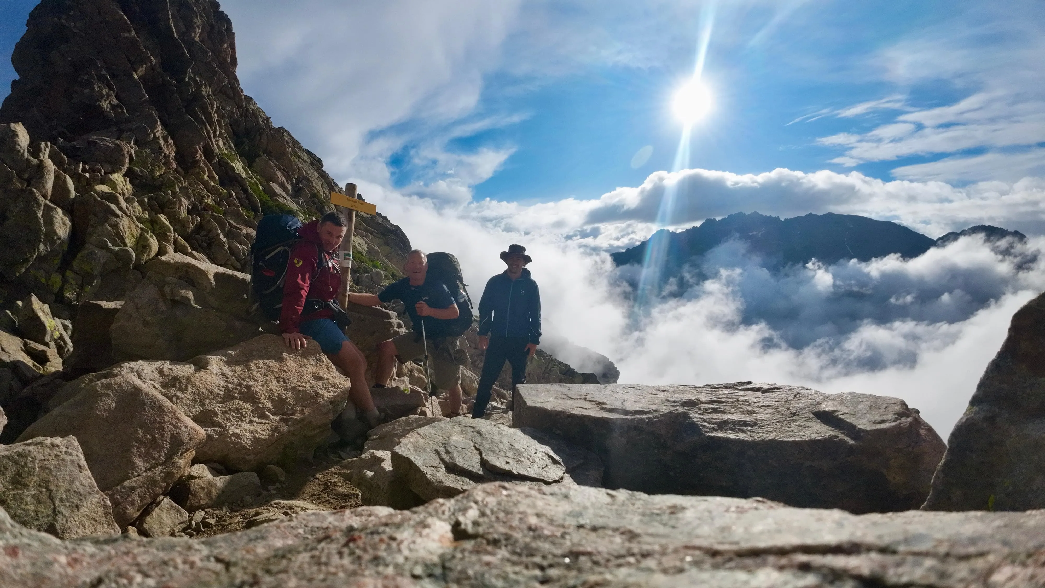
The GR20, also known as fra li Monti, is a GR (Grande Randonnée) hiking trail that crosses the Mediterranean island of Corsica and runs roughly from north to south. The whole route is about 180 km long with an altitude difference of 12,000 m. This GR route is considered one of the toughest of all GR routes. Are you ready for it?
Why both ways?
You can walk the GR20 in either direction, north to south, or south to north. The most popular route starts in Calenzana, in the north, and ends in Conca, in the south. However, if you want to enjoy a quieter route and encounter fewer people, we recommend starting from the south. It's up to you (or the availability of the huts) which direction you choose.
Why book with Bookatrekking.com?
Camping: during this trek, you can also spend the night at camping sites. Contact our trekking experts to find out more about this option!
Route
What's the plan?Stage 1: Calenzana - Refuge d'Ortu di u Piobbu
The 1st stage of the GR20 trail starts in Calenzana (275 m) and climbs to Refuge d'Ortu di u Piobbu (1570 m), which is also its highest point of today's stage. The total ascent is 1295 m and the total descent is only 50 m. The route is difficult and about 10 km long. To complete this stage it will take about 6h30 when walked from Calenzana, or 5 hours in the opposite direction.
Accommodation: Refuge d'Ortu di u Piobbu
Highlights:
- Capu a e Vacche (624 m)
- Capu di Pratu (828 m)
- Capu Jovu (Ghiovu; 1629 m)
- Cirque de Bonifatu
Stage 2: Refuge d'Ortu di u Piobbu - Refuge de Carrozzu
The 2nd stage of the trail starts in Refuge d'Ortu di u Piobbu (1570 m) and ends in Refuge de Carrozzu (1270 m). The highest point is the ridge at 2020 m above Col d'Avartoli. Today's total ascent is 667 m and the total descent is 917 m. Today the route is also challenging. This stage is 8 km long, with an average walking time of 7 hours when walked from Ortu di u Piobbu or about 5 hours in the opposite direction.
Accommodation: Refuge de Carrozzu
Highlights:
- Cirque de Bonifatu
Stage 3: Refuge de Carrozzu - Refuge d'Asco Stagnu
The 3rd stage starts in Refuge de Carrozzu (1270 m) and ends in a ski resort of Haut Asco, at the d'Asco Stagnu refuge, 1422 m. The highest point of the day is Col de Stagni, at 2010 m. The total ascent is 790 m, total descent is 638 m. The route is 6 km long and the average walking time is about 6 hours when walked from Refuge de Carrozzu or about 5 hours in the opposite direction.
Accommodation: Refuge d'Asco Stagnu
Highlights:
- Monte Cinto (2706 m)
Stage 4: Refuge d'Asco Stagnu - Refuge de Tighjettu
The 4th stage starts in Haut Asco (1422 m) and ends in Refuge de Tighjettu (1683 m). The highest point is Col de Minuta, locates at 2183 m. Today's total ascent is 999 m and the total descent is 738 m. The route is 8 km long and the average walking time is about 6 hours in both directions.
Accommodation: Refuge de Tighjettu
Highlights:
- Monte Cinto (2706 m)
- Punta Minuta (2556 m)
- Lac Du Cinto (2289 m)
- Refuge de l'Erco (1667 m)
- Lozzi (1029 m)
- Calasima (1100 m)

Stage 5: Refuge de Tighjettu - Refuge de Ciottulu di i Mori
The 5th stage of the GR20 trail starts in Refuge de Tighjettu (1683 m) and ends in Refuge de Ciottulu di i Mori (1991 m, the highest point of the stage). The total ascent is 607 m and the total descent is only 78 m. The route to Ciottulu di I Mori takes about 4 hours.
Accommodation: Refuge de Ciottulu di i Mori
Highlights:
- Paglia Orba (2525 m)
- Col des Maures (2155 m)
- Calasima (1100 m)
- Albertacce (840 m)
- Col de Vergio (1477 m)
Stage 6: Refuge de Ciottulu di i Mori - Refuge de Manganu
The 6th stage starts in Refuge de Ciottulu di I Mori (1991 m) and ends in Refuge de Manganu (1601 m). The highest point of the trek is Col de Reta, located at 1883 m. Today's ascent is 643 m, with a total descent of 1033 m. Today's trek takes about 8 hours in both directions.
Accommodation: Refuge de Manganu
Highlights:
- Calasima (1100 m)
- Albertacce (840 m)
- Col de Vergio (1477 m)
- Lac de Nino (1760 m)
- Monte Ritondu (2622 m)
- Lac de Creno (1310 m)
- Orto (700 m)
- Soccia (750 m)
- Guagno
Stage 7: Refuge de Manganu - Refuge de Pietra Piana
The 7th stage of the GR20 trek starts in Refuge de Manganu (1601 m) and ends in Refuge de Pietra Piana (1842 m). Today's highest point will be Breche de Capitellu, located at 2225 m. The total ascent of this stage is 830 m and thetotal descent is 589 m. This stage is 10 km long and the average walking time is about 6h30 when walked from Manganu or 6 hours in the opposite direction.
Accommodation: Refuge de Pietra Piana
Highlights:
- Monte Ritondu (2622 m)
- Col du Fer de Lance
- Lac de Melo (1711 m)
- Lac de Capitellu (1930 m)
- Lavu Bellebone (2321 m)
- Lac de Creno (1310 m)
- Orto (700 m)
- Soccia (750 m)
Stage 8: Refuge de Pietra Piana - Refuge de l'Onda
The 8th stage starts in Refuge de Pietra Piana (1842 m, the highest point of the stage) and ends in Refuge de l'Onda (1430 m). It's an easy trek with a total ascent of 490 m and a total descent of 902 m. The route is 10 km long and the average walking time is about 5 hours when walked from Refuge de Pietra Piana or about 15 minutes longer in the opposite direction.
Accommodation: Refuge de l'Onda
Highlights:
- Monte Rotondo (Ritondu; 2622 m)
- Canaglia (600 m)
- Tattone (600 m)
Stage 9: Refuge de l'Onda - Vizzavona
The 9th stage of this trail, and the last one of its northern section, starts in Refuge de l'Onda (1430 m) and descends to Vizzavona (920 m), which is the midpoint between the northern and southern halves of the GR20. The highest point is at 2141 m, the total ascent is 711 m and the total descent is 1221 m. The route is 10 km long, on average it takes 5½ to 6 hours to complete it when walked from Onda or about 7 hours in the opposite direction.
Accommodation: L'Hotel Le Vizzavona
Highlights:
- Bocca du Porco (2159 m)
- Lac d'Oro (1970 m)
- Quagno
- Tattone
- Canaglia
Stage 10: Vizzavona - Bergeries de Capannelle
The 10th stage, and the first one of its southern part, starts in Vizzavona (920 m) and climbs to Bergeries de Capannelle (1586 m). The highest point is Col de Palmente at 1640 m, the total ascent is 890 m and the total descent is 224 m. The route is 15 km long. The average walking time is about 5½ hours when walked from Vizzavona or 4½ hours in the opposite direction.
Accommodation: Gite U Fugone
Highlights:
- Monte d'Oro (2389 m)
- Monte Calvi (1461 m)
- Ghisoni (665 m)
- Lac de Bastani
- Monte Renoso (2352 m)

Stage 11: Bergeries de Capannelle - Refuge de Prati
The 11th stage of the GR20 starts in Bergeries de Capannelle (1586 m) and ends in Refuge de Prati (1820 m). The highest point is at Col d'Oru (1840 m). The total ascent is 642 m and the total descent is 408 m. The route is 16 km long and the average walking time is about 6 hours in both directions.
Accommodation: Refuge de Prati
Highlights:
- Monte Renoso (2352 m)
- Lac de Bastani (2089 m)
- Lac de Rino (1882 m)
- Monte Grosso (1895 m)
- Pozzi (1783 m)
- Punta Capanella (2032 m)
Stage 12: Refuge de Prati - Refuge d'Usciolu
The 12th stage starts in Refuge de Prati (1820 m) and ends in Refuge d'Usciolu (1750 m). The highest point is Punta della Capella at 2041 m, with a total ascent of 677 m and a total descent of 747 m. The route is 11 km long and the average walking time is 5h45 when walked from Prati or 6h30 in the opposite direction.
Accommodation: Refuge d'Usciolu
Highlights:
- Monte Grosso (1895 m)
- Palneca
- Ciamannace
Stage 13: Refuge d'Usciolu - Refuge d'Asinao
The 13th stage of the GR20 trail starts in Refuge d'Usciolu (1750 m) and ends in Refuge d'Asinao (1530 m). The highest point is at Monte Incudine (2134 m). Today's total ascent is 845 m and total descent is 1065 m. The route is 14.5 km long. The average walking time is 8 hours when walked from d'Usciolu or about 30 minutes more in the opposite direction.
Accommodation: Refuge d'Asinao
Highlights:
- Zicavo (750 m)
- Bergeries de Bassetta
- Platau de Coscione
Stage 14: Refuge d'Asinao - Refuge de Paliri
Today the trail starts in Refuge d'Asinao (1530 m) and ends in Refuge de Paliri (1055 m). The highest point is at Cold de Pargulu (1662 m), with a total ascent of 429 m and a total descent of 910 m. The route is 13 km long and the average walking time is about 7 hours when walked from d'Asinao or about 20 minutes longer in the opposite direction.
Accommodation: Refuge de Paliri
Highlights:
- Aigulies de Bavella (1611 m)
- Quenza (813 m)
Stage 15: Refuge de Paliri - Conca
The last stage descends from Refuge de Paliri (1055 m, the highest point of the stage) to Conca (252 m). The total ascent is 160 m only and the total descent is 926 m. The route is 12 km long and the average walking time is 5 hours when walked from Paliri or 6h15 in the opposite direction.
What's included
Included:
√ Booking the huts
We will take care of arranging accommodation for you. We will also provide you with a detailed itinerary for every stage and instructions on how to get to the trailhead.
√ Accommodation in huts
We will arrange your accommodation on the GR20 in mountain huts. The mountain huts along the GR20 offer basic shared accommodation and food. These refuges come under the regional Corsican natural park’s authority and can host 25-50 people depending on the hut. In case the mountain huts are fully booked, we will automatically book a tent for you. In Refuge d'Ortu di u Piobbu and Refuge d'Asinao, you will spend the night in a tent in all cases.
√ Accommodation in Vizzavona
On day 9 of the trek, you will spend the night in a hotel in Vizzavona.
√ Half-board in Bergeries de Capannelle
In Bergeries de Capannelle you will spend the night at Gite U Fugone or similar. Dinner and breakfast are included.
√ Hiking guide
We will provide walking notes describing the walking distance of each stage, altitude differences, the accommodation, and highlights along the way.
Excluded:
× Airfare and Visa
You have to make your way to the starting point of the trek, Calenzana or Conca. The total amount is exclusive of flights or ferry rides to Corsica.
× Transfers
Once in Corsica, you will have to make your way to the trailhead at Calenzana or Conca. We will provide the instructions and assist you with how to get there. The bus tickets are not included.
× Travel Insurance
Your international travel insurance is your own responsibility. Discuss your itinerary with the insurance company before your trek.
× Meals
Half-board is not included in the price of this trek (except in Bergeries de Capannelle). You can get something to eat at the mountain huts along the way or you can get food from the towns below the trail. If you want to have a warm dinner at the hut, remember to ask for it as soon as you get to the hut.
× Accommodation before and after the trek
This trek does not include the accommodation before and after the trek. Only hut accommodation during the trek is included.
× Personal expenses
Personal expenses such as souvenirs, drinks, and other similar expenses are for your own account.
Accommodation
AccommodationOn days 9 and 10 of the trek, you will spend the night in hotels in Vizzavona and Bergeries de Capannelle in shared dormitories. The remaining nights on the GR20 will be in mountain huts. In case the mountain huts are fully booked, we will automatically book a tent for you. The mountain huts along the GR20 offer basic accommodation and food. These refuges come under the regional Corsican natural park’s authority and can host 25-50 people depending on the hut. Hosts manage the huts from the end of May to early October. Outside of this time frame, the refuges are open but not manned and there is no food available. The refuges usually have one large dormitory with long wooden bunk beds equipped with mattresses. You can also sleep in a tent near the refuges. You can rent a tent at the hut as well. It is forbidden to camp in other places along the trail. Independent of which accommodation type you choose, you must always bring your own sleeping bag. Huts do have electricity. However, charging your phone or camera can be quite a challenge given the number of trekkers and the limited number of sockets. Make sure to carry extra batteries with you.
What to expect in the huts:
- Indoor kitchen and eating area
- Dormitory room with bunk beds
- The bunk beds have two levels and have mattresses side by side. Bring your own sleeping bag
- Cold outdoor showers and toilets
- An outdoor kitchen with cooking facilities
- Bins for rubbish

What is the food like in the huts?
Half board is not included when you book your accommodation. You can choose to carry food with you or you can get your meals at the huts. You can always find a freshwater spring in the vicinity of the refuges. You can also buy food and book a hot meal and breakfast. Bear in mind that the hot meals must be reserved on arrival.
Breakfasts are often prepared the night before and handed out so you can leave as early as you want the next day. As regards lunch, if you are passing a refuge between 12h and 14h you will often find a small lunchtime menu with choices, such as cheese and omelets, pasta, Corsican soup, and plates of smoked charcuterie. If you order dinner (remember to ask for it as soon as you get tot he hut!), it is usually served from 19h onwards. There may be more trekkers than seats available, so be patient. Dinner usually consists of three courses which vary from hut to hut. Bear in mind that you will be in the mountains, so don't expect over elaborated dishes. Also, you will be expected to bring your own knife to mealtimes, so don't forget to carry one!
Menus vary from one hut to the other and their meals usually depend on the stock they have. Hot dinners can cost between 15-20 euros, while breakfast and dinner cost around 8-12 euros each. Refuges are the only places where you can buy food and get drinking water along the trail. However, there are some stages where you can go shopping in the villages below.
All refuges have an indoor kitchen that you can use. These are equipped with gas, water, and kitchen utensils. Remember to always keep a lighter, or match with you! You might find there are only 4 gas rings available for a large number of hungry trekkers, so try to be patient.
Packing List
Packing ListPacking the right clothes and equipment is essential for any trekking adventure. For the GR20 trek, you must make sure that you carry clothes for warm temperatures during the day, but also for quite chilly nights and mornings. Make sure that you don't overpack. 2 or 3 t-shirts are ok, you can wash them at the hut at night and they will be ready to use again the next morning.
- Rucksack (35-45 liters)
- Hiking boots, worn in
- Socks
- Shorts and T-shirts
- Swimwear
- Waterproof jacket
- Warm fleece
- Thermal hat and Thermal gloves
- Waterproof trousers (optional)
- Hat
- Sun cream and lip balm
- Sunglasses
- Water bottle and/or camel bag
- Tupperware lunch box (optional)
- Fork or spoon
- Penknife (knives are often not provided in the refuges)
- Basic first aid kit
- Toilet paper / pocket tissues / plastic ziplock bags
- Small mirror (optional)
- Walking poles
- Headlamp
- Casual Wear for the huts
- Earplugs (optional)
- Sleeping bag -5° comfort
- Energy bars and snacks
FAQ
FAQ
Where is the GR20 route?
GR stands for Grande Randonnée, which means something like "big excursion" in French. The GRs are a network of long-distance trails in Europe located mostly in France, Belgium, the Netherlands, and Spain. The GR20 is considered to be the most difficult of all these routes and is located on the French island of Corsica, Corse in French, on the Tyrrhenian sea. Its Corsican name is Fra li Monti, which means "across the mountains" in Corsican.
What is the best season for the GR20 hike?
If you are planning your GR20 trek, we advise you to go in late June or early September. During this time, most huts are open and the weather is not too hot. Also, the trail won't be as crowded as during July or August.
Between November and May, there is snow on the trails, which makes the trek quite dangerous. Also, during these months there are no hosts in the refuges, which means that you have to carry all the food. During winter, from February to April, the GR20 can only be completed by experienced cross-country skies with a professional guide. This winter variant of the GR20 is known as l'Alta Strada.
How do I get to Corsica?
As mentioned above, Corsica is a French island on the Tyrrhenian sea, also known as Corse in French. You can reach the island either by boat or by plane. There are 4 airports on the island, 2 in the north and 2 in the south. If you are planning on starting the trek from the north, then it is advisable to land in Calvi (CLY). If you are planning on starting from the south, the closest airport to Conca is Figari (FSC). The airlines flying directly to the island are Air France and Air Corsica, with flights departing from Paris, Marseille, and Nice. The flights take usually 1 to 1,5 hours.
You can also reach the island by boat. Between April and September, there are daily ferry rides from Toulon, Nice or Marseille. Of course, this option is cheaper than the plane but it also takes longer. The ferry ride from the coastline to the island takes around 6 hours. If you want to take a ferry to the southern section of the island, it will be even longer.
How do I get to the starting point of the GR20 walk?
The starting and endpoints of the GR20 are Calenzana village in the north of the island and Conca in the South. Vizzavona is the midway point and easily accessible if you want to walk one half of the trail.
Once you get to a port or airport in Corsica, it is quite easy to get to the trailhead, both north, and south. If you land in Calvi (north), you can take a 30-minute ride by bus or cab to Calenzana. A cab usually costs between 20 and 30 euros per ride while the bus costs around 8 euros. If you land in Figari (south), we recommend taking a bus to Conca. The ride is 2,5 hours long and taking a taxi to Conca can be quite expensive.
GR20 Corse - Should I start from the North or from the South?
You can walk the GR20 trail in either direction, from north to south, or from south to north. Which is the best option? Well, it depends on your physical condition and what you expect from the whole experience. The trail can be divided into two parts: the northern part starts in Calenzana and stops in Vizzavona. It is the most difficult part, because of the steep and rocky path, but it is also considered the most beautiful half. The southern part of the Gr20 goes from Vizzavona to Conca (or the other way around) and is easier, but less spectacular. The Coscione plateau with its green meadows is, however, quite breathtaking.
You can walk in either direction through the whole trail or you can choose to walk any of the two halves. The traditional route starts in the north and ends in the south. Since the GR20 can be quite crowded and most hikers walk southwards, some people recommend starting from the south and making your way to the north.
Safety
SafetyThe GR20 is a demanding but safe trek and the trail is quite well signposted along the way with red and white rectangles on rocks, boulders, and trees. There are also small stone heaps along the trail. Alternative paths are marked with a different color. Bear in mind that it is easy to get on an alternative path without meaning to or to lose your way, so having a good map and a compass is necessary.

Huts do have electricity. However, charging your phone or camera can be quite a challenge given the number of trekkers and the limited number of sockets. Having a charged phone is not just a luxury, it is also a safety measure. You might not need it for yourself, but if you come across an injured trekker, you will need to ask for help and a charged phone is key. Make sure to carry extra batteries with you or a solar charger.
COVID-19
GR20 and Covid-19
The GR20 is a perfect option to avoid having to stay in overcrowded hotels in coastal countries and to socially distance oneself from others. But obviously, you still will have to spend the night at huts where you will certainly not be alone. In order to keep the COVID-19 pandemic under control, the following must be taken into account:
- Do not visit the Huts if you have symptoms!
- Huts aren't allowed to work at full capacity, so make sure to book your stay in advance
- Bring your own facemask!
- You must bring your own sleeping bag, liner, and pillow cover
- Bring your own travel towel
How to Book
How to Book
On Bookatrekking.com you can find and compare the adventures of your dreams. Is this trekking your match? In that case, you can proceed with your booking. At Bookatrekking.com you make a deposit of 15% of the total amount. In the case of this trek, we will check the availability at the respective accommodations for you. There are two possible outcomes:
√ There is availability
We ask once again for a deposit of 15% to secure all accommodation for you. The remaining 70% must be paid at least two (2) weeks before the start of the trekking.
X There is no availability
If there is no availability, we will look for other starting dates or another trekking in agreement with you. Are there no other options for you? Then your deposit of 15% will be refunded.
Cancellation Policy
If all the accommodations of this trekking are booked and confirmed, you will lose your deposit of 30% at all times. If you cancel within 14 days of your start date, you will lose your full booking amount.
Is it not quite clear yet or do you have questions? Please contact us via support@bookatrekking.com. We are happy to help you.
COVID-19
Covid-19
The Corona pandemic has had its grip on us, and mountain huts in the Alpine region have had to take several preventive measures over the past two years. In the meantime, the first relaxations in the Alps are noticeable, yet it is definitely still a factor to take into account. Some Covid restrictions that are worth mentioning:
- Don't go to the huts if you have symptoms!
- Not all mountain huts are allowed to operate at full capacity yet, so make sure you book your stay in advance.
- To be on the safe side, always take a mouth mask with you.
- In some mountain huts it is still compulsory to bring your own sleeping bag, in others a sheet bag and pillowcase are sufficient. Your personal travel guide will tell you which rules apply to your route.
- Bring your own towel
How to Book
How to Book?
On Bookatrekking.com you can find and compare the adventures of your dreams. Is this trekking your match? In that case, you can proceed with your booking. At Bookatrekking.com you make a deposit of 30% of the total amount. In the case of this trek, we will check the availability at the respective accommodations for you. There are two possible outcomes:
√ There is availability
We go ahead and make all necessary arrangements for your trip. Once confirmed, we will send you a confirmation and your personal hiking guide. The remaining 70% must be paid at least two (2) weeks before the start of the trekking.
X There is no availability
If there is no availability, we will look for other starting dates or another trekking in agreement with you. Are there no other options for you? Then your deposit of 30% will be refunded.
Cancellation Policy
If all the accommodations of this trekking are booked and confirmed, you will lose your deposit of 30% at all times. If you cancel within 14 days of your start date, you will lose your full booking amount.
Is it not quite clear yet or do you have questions? Please contact us via support@bookatrekking.com. We are happy to help you.
Gallery
These treks you might like
7-day Pindos hiking & Alpine Lake hopping
Operated By No FootprintDuring our 7-day trek, you will explore two of the highest mountains of Greece – Smolikas and Tymfi – and their alpine...
Ultimate Chaltén Trek
Operated By Serac ExpedicionesA complete North to South, 6-day trekking program going around the most attractive points of El Chalten with amazing views of Fitz Roy,...
Full Mullerthal Trail (Route 1, 2 & 3)
Operated By Bookatrekking.com TripsThere is no better way to discover 'Little Switzerland' than by hiking the full Mullerthal Trail. During this trek, you will complete Routes...
Langtang Circuit Trek
Operated By Nepal Eco AdventureNestled between the main Himalayan range to the north and a relatively lower range of snowy peaks to the south, Langtang Valley is a very...
Pieterpad: Montfort - St. Pietersberg (4 days) - Bookatrekking.com
Operated By Bookatrekking.com Trips
Self Guided W-Trek (Camping)
Operated By Chile Nativo TravelFor those travelers ready to start an adventure on their own but don’t want to worry about the details of reservation and...