Call us on: +31 850161354
    Languages
  • English
  • Español
  • Deutsch
  • Nederlands
    Currencies
  • € Euro
  • £ British Pound
  • USD $
  • CAD $
  • SEK
  • NOK
  • DKK
  • AUD $
  • CHF
  • NZD $
  • ZAR
  • HK $
  • SGD $

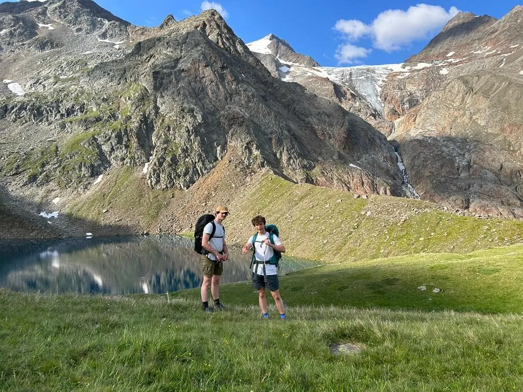
Half Stubaier Höhenweg

Tourismusverband Stubai - 5 days

    Regular days with
  • 0 - 10 km per day
  • 500 - 1000m ascent per day
  • T3 Trails
Overview
Route
What's included
Accommodation
Packing List
FAQ
Safety
COVID-19
How to Book

Overview

The Stubaier Höhenweg, or the Stubai High Trail, is one of the most beautiful hiking trails in the Austrian Alps. The hike begins in the village of Neustift in Stubaital in the heart of Tyrol, not far from Innsbruck. The Stubaier Höhenweg is the highlight of hut-to-hut hikes in Austria and can be walked by young and old if they are sufficiently prepared. 
 
During this 5-day Stubai Höhenweg, you will hike some of the most beautiful stages and stay every night in one of the beautiful mountain huts. This version of the Höhenweg starts at the Sulzenau Hut and ends at the Innsbrucker Hut. Tourismusverband Stubaital makes sure that your stay at all huts on the Höhenweg is arranged. Half board is also booked for you. In this way, you don't have to carry food along the way and you can relax carefree when you're not hiking.
 
Why book with Bookatrekking.com?
 
You can do the Stubaier Höhenweg completely independently. However, putting together the right route including booking all accommodations can be a complicated matter. Tourismusverband Stubai has warm contacts with all cabins on the Stubaier Höhenweg and they are happy to take that burden off your shoulders. Contact our Trekking Experts for free travel advice and arranging your hike will be a piece of cake. 

Route

What's the plan?

Day 1) Neustift to Sulzenau Hütte
The easiest way is to take the bus directly from Neustift to the bus stop Sulzenauhütte. You need to take the bus of the Innsbrucker Verkehrsbetriebe (IVB) line ST. There is also free parking at this bus stop for those who prefer to go by car. 

From the bus stop you walk along the Wildwasserweg in about 2.5 hours to the Sulzenauhütte. On the way you will encounter a number of beautiful waterfalls.
 
Vertical gain: 580 m up
Duration: 1,5 hours
Distance: 5 km
Lowest point: 1.600 m
Highest point: 2.180 m
 
Day 2) Sulzenau Hütte - Nürnberger Hütte
Many hikers describe the 5th stage as the most scenically beautiful stage of the Höhenweg. From green mountain meadows with rushing streams, to stone fields with calm mountain lakes, to snow-white glacier giants, everything is there. On this stage, you also have a choice of two variants - via the Niederl or via the Mairspitze.
 
Vertical gain: 650 m up and 550 m down
Duration: 4 hours
Distance: 5 km
Lowest point: 2,190 m
Highest point: 2,612 m
 
Day 3) Nürnberger Hütte - Bremer Hütte
At this stage, we see the shaping influence of the glaciers on the landscape and the rock formations. The panorama and the unique landscape design are inspiring. It makes sense that this part of the Höhenweg is dubbed Paradies, German for Paradise.
 
Vertical gain: 600 m up and 450 m down
Duration: 4 hours
Distance: 5 km
Lowest point: 2,229 m
Highest point: 2,741 m
 
Day 4) Bremer Hütte - Innsbrucker Hütte
The last stage of the Stubaier Höhenweg lies before you. Don't be mistaken, this is a tough one: the hike from the Bremer Hütte to the Innsbrucker Hütte is certainly one of the most demanding stages of the Stubaier Höhenweg. 6 to 7 hours walking time must be taken into account on this stage, plus 3 ascents (with a respective difference in altitude of approx. 200 to 300 meters). This section of the trek through the Stubai Valley is for experienced mountain hikers and a "fair-weather route". Be careful in bad weather. 
 
Vertical gain: 800 m up and 850 m down
Duration: 7 hours
Distance: 9.5 km
Lowest point: 2,220 m
Highest point: 2,562 m
 
Day 5) From Innsbrucker Hütte via mountain station Elferlifte to Neustift
In about an hour you can hike from the Innsbrucker Hütte to the Karalm. From here it takes about another 2 hours to Elferhütte. From here you can take the ski-lift to mountain station Elferlifte. From here, take the cable car back to Neustift. 

Vertical gain: 400m up and 740m down
Duration: 4 hours
Distance: 8,5 km
Lowest point: 1.760 m
Highest point: 2.350 m

What's included

Included:

√ Booking of the huts
We take care of the organization of the accommodation. We also give detailed directions for each stage and instructions on how to get to the trail. 
 
 Accommodation
We organize accommodation on the Stubaier Höhenweg in mountain huts. The availability of the tour depends entirely on the availability of the huts. See under accommodation which mountain huts are used. 
 
 Half-board
Accommodation in the cabins includes dinner and breakfast. We can also arrange this for you.  Please note that lunch is not included, but in most of the huts you can have breakfast at no extra charge. 

Excluded:

× Transport to and within Austria
You have to find your own way to Neustift in the Stubaital. Transportation to and from Austria is not included in the price. Bus tickets and other transport costs are not included. 
 
× Accommodation before and after the tour
Before and after the tour you have to take care of your own accommodation.
 
× Travel insurance
You are responsible for your own international travel insurance.
 
× Cable car
Rides on the cable car are excluded from the total price. 
 
× Lunch
Half board is included in the price of this tour. However, lunch is in principle exclusive. You can get a packed lunch in the mountain huts along the way.
 
× Personal expenses
Personal expenses such as souvenirs, drinks, and other similar expenses are at your own expense.

Accommodation

Accommodation

On the Stubaier Höhenweg the following huts are included: 

Sulzenau Hütte
The Sulzenauhütte is a fantastic place to spend a few days in the mountains. Fantastically located in the "green", where young and old can indulge. Dive into the crystal clear lake, climb to the summit cross on the Aperen Freiger (3,262 m) or simply enjoy the "Alpine life" with a latte and apple strudel. And always the Sulzenaugletscher in sight!


Nürnberger Hütte
Welcome to the Nürnberger hütte, built in 1886 amidst imposing glacier cliffs. Here you will be pampered with culinary delights from the own farm and regional products. Enjoy the "Marende" or a piece of homemade cake on the sun terrace with the newly built veranda.


Bremer Hütte
The Bremer Hütte was built in 1897 by the DAV - section Bremen. This is a small rustic hut in the midst of small waterfalls and mountain lakes. Backpack transfers from the valley station with the material cable car are offered, as well as a backpack transfer from the Innsbrucker Hütte.


Innsbrucker Hütte
The Innsbrucker Hütte is located at 2,369 m above sea level and is the starting point for numerous mountain tours and hikes. At 3,277 m, the Habicht is the dominant massif on the Elferkamm and is one of the most beautiful and impressive panoramic mountains in the Stubai Alps. Enjoy! 

Packing List

Packing List
 
It doesn't matter where you go hiking or for how long. Bringing the right gear is of utmost importance. For the Stubaier Höhenweg, first of all you need a good backpack. The size of your backpack depends on the number of days you are going to hike in the mountains, the season and the clothes you bring. We have prepared a packing list with some essential clothing items you should bring and some extras you might find useful:  
 
Essentials
- Hiking boots (broken in) 
- Hiking socks 
- Base layer tops - ideally thermal 
- Mid layer tops (e.g. fleece)
- Trekking trousers 
- Hat for warmth or shade 
- Gloves 
- Waterproof jacket 
- Waterproof pants 
- Casual clothing & footwear for evening.  
- Nightwear and underwear 
- Water bottle 
- Sunglasses & sunscreen 
- Toiletries   
- Cash & coins
 
Extras
- Small first aid kit 
- Blister plasters 
- Insect repellent 
- DEET e.g.  
- Camera and charger 
- Map and compass  
- Whistle 
- Book to read 
- Energy snacks
- Walking sticks 
- Buff

FAQ

Where is the Stubaier Höhenweg? 
The Stubaier Höhenweg begins in Neustift im Stubaital in the Austrian Tyrol not far from Innsbruck. 
 
How difficult is the Stubaier Höhenweg? 
The Stubaier Höhenweg is one of the most beautiful high-altitude hiking trails in the Alps, but also places corresponding demands on hikers. The route runs exclusively through mountainous terrain and is partly secured with steel cables. Experience with high altitude mountain trails is a prerequisite when booking the Stubaier Höhenweg. 
 
Especially in bad weather, the difficulty of the high altitude trail increases significantly. Glaciers do not have to be climbed or crossed during the entire route, but steep old snowfields are to be expected, especially at the beginning of the season. Light crampons or spikes and potentially an ice pick can be very useful on these old snowfields. In the meantime, most areas at risk of falling are equipped with steel cables. A three- or four-day Stubaier Höhenweg can be done by families, but if you want to do the entire circuit, it is best to be fully prepared. Only do this if you have done a shorter hut trek before. 
 
Best season for the Stubaier Höhenweg
The season for the Stubaier Höhenweg is short, but it is worth it. And if you miss the season, then you should know that there are plenty of winter sports opportunities in the pre-season and in the winter season. The huts usually open in June, and it will be possible to complete the entire high-level trail from the beginning of July. In June you can still expect some snow on the left and right, which will prevent you from doing some stages. The best months for the Stubaier Höhenweg are July, August, and September.
 
The weather in the mountains can be unpredictable and sometimes it is too dangerous to continue the trail. This can force you to spend an extra night in the hut where you are staying. This is for your own safety. A telephone call to the nearest hut will ensure that you can continue your high-altitude trail on a clear day.
 
Stubaier Höhenweg GPX files 
Below you will find links to all GPX files of the stages of the Stubaier Höhenweg with an ascent to the Starkenburger Hütte.

Etappe 1) Starkenburger Hütte – Franz-Senn-Hütte
Etappe 2) Franz-Senn-Hütte – Neue Regensburger Hütte
Etappe 3) Neue Regensburger Hütte – Dresdner Hütte
Etappe 4) Dresdner Hütte – Sulzenau Hütte
Etappe 5) Sulzenau Hütte – Nürnberger Hütte
Etappe 6) Nürnberger Hütte – Bremer Hütte
Etappe 7) Bremer Hütte – Innsbrucker Hütte

And of course, there are also GPX files with the Innsbrucker Hütte as the starting point. Find them below:

Etappe 1) Innsbrucker Hütte - Bremer Hütte
Etappe 2) Bremer Hütte - Nürnberger Hütte
Etappe 3) Nürnberger Hütte - Sulzenau Hütte
Etappe 4) Sulzenau Hütte – Dresdner Hütte
Etappe 5) Dresdner Hütte - Neue Regensburger Hütte
Etappe 6) Neue Regensburger Hütte - Franz-Senn-Hütte
Etappe 7) Franz-Senn-Hütte - Starkenburger Hütte

Safety

Safety on the Stubaier Höhenweg
 
The Stubaier Höhenweg is one of the most beautiful high-altitude hiking trails in the Alps, but also places corresponding demands on hikers. The route runs exclusively through mountainous terrain and is partly secured with steel cables. Experience with high altitude mountain trails is a prerequisite when booking the Stubaier Höhenweg. 
 
Especially in bad weather, the difficulty of the high altitude trail increases significantly. Glaciers do not have to be climbed or crossed during the entire route, but steep old snowfields are to be expected, especially at the beginning of the season. Light crampons or spikes and potentially an ice pick can be very useful on these old snowfields. In the meantime, most areas at risk of falling are equipped with steel cables. A three- or four-day Stubaier Höhenweg can be done by families, but if you want to do the entire circuit, it is best to be fully prepared. Only do this if you have done a shorter hut trek before. 
 
Important telephone numbers
Alpine rescue service
Phone number: 140
European Emergency Number
Phone number: 112
 
No network?
Without network and without coverage the emergency numbers are not reachable. Find a better location and try to call 112 regularly.
European emergency number: Reachable via any available network by dialing 112 instead of the PIN code or by using the SOS alarm function.
 
Reporting accidents
Who reports the accident? / Number to call back?
Where exactly did the accident take place?
What happened?
How many injured?
 
Alarm App Mountain Rescue Service Tyrol
If you have a smartphone, you can install the new alarm app of the Tyrolean mountain rescue service. The app helps you to send an alarm call and the location data.
 
Google Play: https://play.google.com/store/apps/details?id=at.tirol_notfall&hl=en_US
Apple Store: https://apps.apple.com/us/app/sos-eu-alp/id400099520 

COVID-19

Covid-19

The Corona pandemic has had its grip on us, and mountain huts in the Alpine region have had to take several preventive measures over the past two years. In the meantime, the first relaxations in the Alps are noticeable, yet it is definitely still a factor to take into account. Some Covid restrictions that are worth mentioning:

- Don't go to the huts if you have symptoms!

- Not all mountain huts are allowed to operate at full capacity yet, so make sure you book your stay in advance.

- To be on the safe side, always take a mouth mask with you.

- In some mountain huts it is still compulsory to bring your own sleeping bag, in others a sheet bag and pillowcase are sufficient. Your personal travel guide will tell you which rules apply to your route.

- Bring your own towel

How to Book

How to Book?

On Bookatrekking.com you can find and compare the adventures of your dreams. Is this trekking your match? In that case, you can proceed with your booking. At Bookatrekking.com you make a deposit of 30% of the total amount. In the case of this trek, we will check the availability at the respective accommodations for you. There are two possible outcomes:

 There is availability 
We go ahead and make all necessary arrangements for your trip. Once confirmed, we will send you a confirmation and your personal hiking guide. The remaining 70% must be paid at least two (2) weeks before the start of the trekking.

X There is no availability 
If there is no availability, we will look for other starting dates or another trekking in agreement with you. Are there no other options for you? Then your deposit of 30% will be refunded.

Cancellation Policy
Bookatrekking.com is dedicated to providing the best possible experience for you. We understand that life can be unpredictable and that plans may change. In recognition of this, we have created a flexible cancellation policy for our trekkings. You may cancel your trekking reservation free of charge if you notify us at least 14 days prior to the scheduled departure date. If you cancel within 14 days of your start date, you will lose your full booking amount.

Is it not quite clear yet or do you have questions? Please contact us via support@bookatrekking.com. We are happy to help you.


Pay only a deposit now!
From
per person
See Group Discount
1 Person
2 Persons
3+ Persons
Available!
May 2023
Mon
Tue
Wed
Thu
Fri
Sat
Sun
Persons
Start Date:
End Date:
Persons
2
Booking cost
Pay now
Send Inquiry

About us

At Bookatrekking.com you'll find the treks that will make your life unforgettable. Whether you want to discover the Inca Trail or climb the Kilimanjaro, Bookatrekking.com offers a wide and varied range of services. Here, no false promises are made, prices are transparent and every booking is confirmed immediately. Find, compare, book and trek.

Contact our trekking expert

Our trekking experts are happy to help you out! Please submit your inquiry and we will get back to you as soon as possible!

+1 6466654681
+44 3455280097
+34 960130010
+31 850161354
info@bookatrekking.com

+
Filter Book now Contact us