Full Berliner Höhenweg

Duration: 8 days
Trails: T4 trails
Distance: 15 - 20 km per day
Ascent per day: 500 - 1000 m ascent per day

> Hike the full high alpine Berliner Höhenweg in the Zillertaler Alps
> Spend the night in huts with stunning views
> Bookatrekking.com arranges all the huts along the way

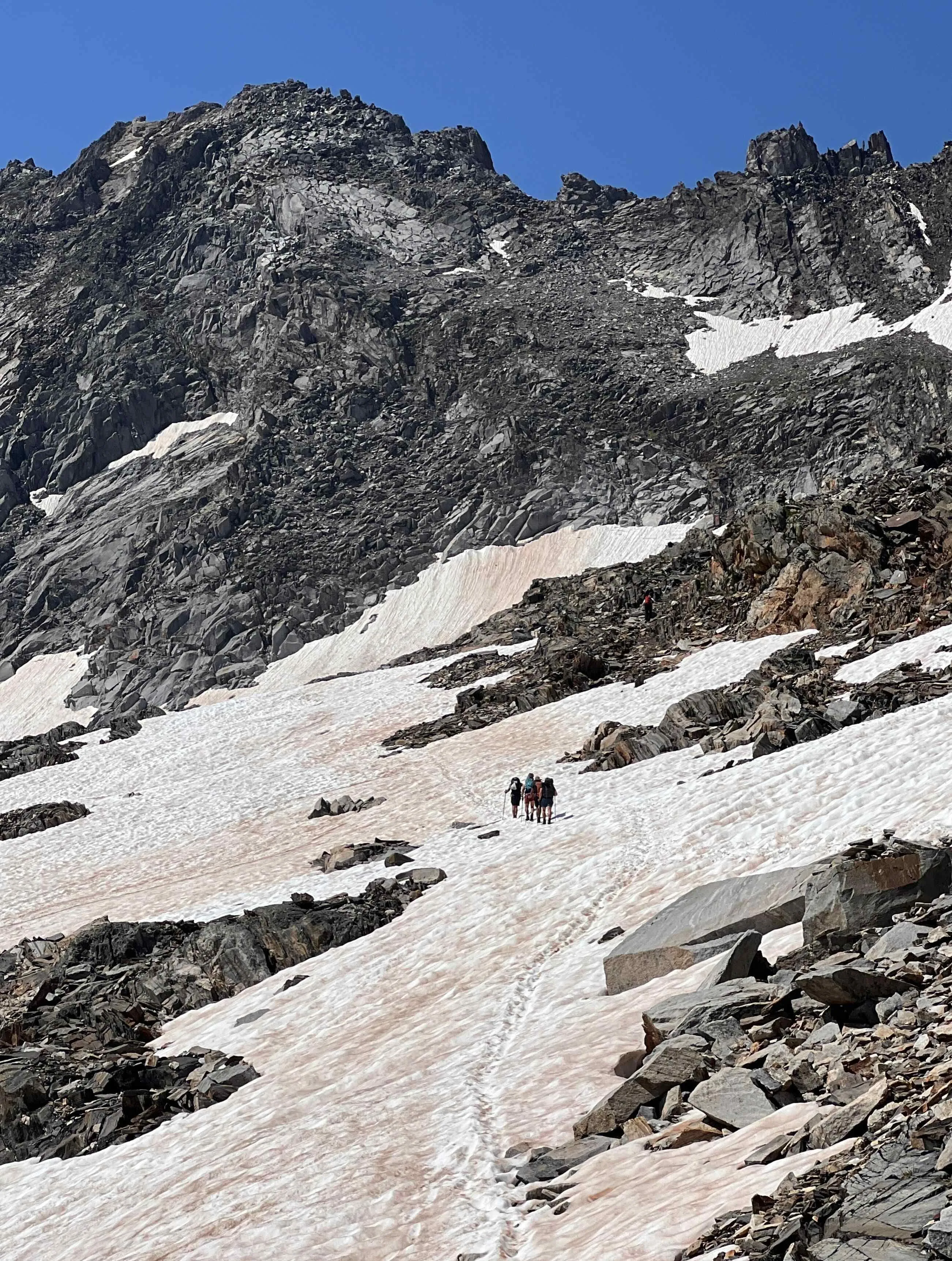
Are you ready for a wild hiking adventure? Then the Berliner Höhenweg should definitely be on your bucket list. The challenging route leads through the high alpine terrain of the Zillertal Alps. With two tough mountain passes and the ascent of the 3134 meter high Schönbichler Horn you'll tackle lots of vertical gain. The terrain can be technically challenging in some sections with steep trails, snow fields, and rocky terrain. The efforts are rewarded with stunning views of the peaks and glaciers of this rugged massif, weather permitting of course.

Itinerary

Day
1

Mayrhofen - Karl von Edelhütte

Duration: 05:50 h
Distance: 9 km
Ascent: 1600 m
The starting point is in Mayrhofen, where you can park your car. Walk towards the Ahornbahn and follow the Ziller river until the paved road turns into an unpaved one. From here, a well-defined path steeply ascends, with the Ahornbahn on your right and the Ziller on your left. After a challenging climb, you will reach the Wirtschaftshaus Alpenrose, where you can take a break on the terrace with a drink. After this welcome stop, it's time to climb again. The path zigzags uphill until it meets the path coming from the Ahornbahn. From here, you will walk for another half hour to reach the Karl von Edelhütte. Alternatively, you can take the Ahornbahn, which cuts 6 kilometers and 1300 meters of altitude gain from the route.

Karl von Edelhütte

Info
Karl von Edelhütte
Day
2

Karl von Edelhütte - Kasseler Hütte

Duration: 06:45 h
Distance: 13.1 km
Ascent: 540 m
Descent: 610 m
Today is a challenging day. High above the Stilluptal, you traverse below the peaks of the Ahornkam towards the Kasseler Hütte. Although you don't cross a real mountain pass, there is a lot of climbing and descending involved. The Krummschnabelscharte is literally the highlight of this stage, where you should not have a fear of heights. The narrow path runs along spectacular rock formations and is secured with a cable. After reaching the 2478-meter-high pass, you will continue towards the Nofertenschneid, another magnificent passage with pointed rocks. Here too, you can use cables to descend. From here, it is an 8-kilometer walk over uneven terrain to the Kasseler Hütte. Don't forget to enjoy the view from time to time!

Kasseler Hütte

Info
Kasseler Hütte
Day
3

Kasseler Hütte - Greizer Hütte

Duration: 05:45 h
Distance: 9.8 km
Ascent: 670 m
Descent: 620 m
From the hut, you walk towards the beautiful suspension bridge that hangs over the Stillupbach. Follow the path to the Eisenklamm gorge. Here the climb starts to the top of the Lappenscharte, a difficult pass at 2700 meters altitude. You walk along a narrow path along a deep ravine. Cables and railings have been installed to make this section safer. Just before the pass, you need to scramble here and there. Once you reach the top, you feel like you've climbed a mountain. The short descent to the Greizer Hütte is a bit easier. Time for a well-deserved Kaiserschmarrn!

Greizer Hütte

Info
Greizer Hütte
Day
4

Greizer Hütte - Berliner Hütte

Duration: 07:15 h
Distance: 10.8 km
Ascent: 1010 m
Descent: 1180 m
It is a good idea to warm up before starting this stage. The trail descends steeply for 400 meters towards the Floitenbach, a stream that drains the meltwater from the Floitenkees glacier. Then it's a challenging climb of about 1000 meters in altitude to the nördliche Mörchenscharte. Some sections are equipped with ladders and cables. This may be the hardest part of the Berliner Höhenweg. The Mörchenscharte itself is a narrow passage over the mountain ridge. The landscape here is incredibly rugged with many boulder fields and glaciers higher up. Do not underestimate the descent to the Berliner Hütte. You will descend over difficult terrain for 5 kilometers, dropping more than 800 meters.

Berliner Hütte

Info
Berliner Hütte
Day
5

Berliner Hütte - Furtschaglhaus

Duration: 06:50 h
Distance: 8.7 km
Ascent: 1080 m
Descent: 830 m
You cross the Hornkeesbach over smooth rock surfaces and stay at the same altitude until the trail junction. Like previous days, today involves another ascent, this time up the Schönbichler Scharte, with 3060 meters the highest pass of the Berliner Höhenweg. This stage feels like an alpine experience. You walk almost directly under the glaciers and have a view over the entire Zillertal Alps. As a bonus, from the pass you can climb the Schönbichler Horn (3134m). The top of the pass is secured with cables. The steep descent takes you 800 meters lower to the Furtschaglhaus.

Furtschaglhaus

Info
Furtschaglhaus
Day
6

Furtschaglhaus - Friesenberghaus

Duration: 09:20 h
Distance: 18.5 km
Ascent: 1050 m
Descent: 860 m
After a short steep descent, you walk comfortably on flat terrain along the shores of the Schlegeis reservoir. At the north end of the lake, you can have a drink and eat something before climbing again. At the intersection of two trails, around an altitude of 2350 meters, you will find the fantastic Olpererhütte. This is also an option for lunch. Further along the route, you will cross the suspension bridge with a clear view of the Schlegeisspeicher. From here it's another two hours of walking to the Friesenberghaus.

Friesenberghaus

Info
Friesenberghaus
Day
7

Friesenberghaus - Gamshütte

Duration: 08:30 h
Distance: 16.6 km
Ascent: 560 m
Descent: 1110 m
The last long hiking day from Friesenberghaus to Gamshütte should not be underestimated. You will quickly pass by the Wesendlkarsee, a beautiful mountain lake. Are you brave enough to take a swim? Along the flanks of the Höher Riffler, you walk to Pitzenalm. The trail then becomes more challenging, with large scree fields making walking more difficult. When you see Mayrhofen in the distance, it is not far to Gamshütte.

Gamshütte

Info
Gamshütte
Day
8

Gamshütte - Finkenberg - Mayrhofen

Duration: 02:50 h
Distance: 6.9 km
Descent: 1050 m
On the last day, you mainly descend through pine forests and alpine meadows. Soon you will walk into the cute village of Finkenberg from where you can take a bus or taxi back to your well-deserved hotel in Mayrhofen. Here you can look back on an epic trek!
See entire itinerary

Included

  • Full travel guide

    We will send you on your way with a digital travel guide that includes a route description for the Berliner Höhenweg, interactive hiking maps, and the most important information applicable to your trek

  • Accommodation

    During your Berliner Höhenweg, you will spend your nights in mountain huts. In the mountain huts we normally only book dormitories, but we can look into private rooms on request. If the private rooms are fully booked or not available in the hut, we automatically book a bed in dormitories for you. Please note that private rooms are more expensive and there will be an additional charge for this.

  • Half-board

    Accommodation at the huts includes dinner and breakfast. We will arrange this for you as well. This allows you to travel lighter and have one less thing to worry about. Bear in mind that lunch is not included, but it can be purchased at the huts. Here you can also buy an array of snacks and bottled water.

Excluded

  • Traveling to and from

    You have to make your own way to the starting point. The total amount does not include personal transport.

  • Transfers

    Should you need any form of (public) transport on location, this is not part of the trekking package. This includes the use of taxi, bus, cable cars, gondolas, ferries, etc.

  • Lunch

    Half-board is included in the price of this trek. Lunch, however, is not. You can get something to eat at the mountain huts along the way.

  • Travel Insurance

    Your international travel insurance is your own responsibility. Discuss your itinerary with the insurance company before your trek.

  • Personal expenses

    Personal expenses on such as souvenirs, drinks, and other similar expenses are for your own account.

FAQ

  • What and Where Is the Berliner Höhenweg?

  • Is the Berliner Höhenweg Suitable for Me?

  • What Is the Best Season for the Berliner Höhenweg?

How to Book

  • Booking

  • Availability

  • Cancellation policy

Just for You