Laugavegur Trail and Fimmvörðuháls Hike - Including accommodation before and after
Bookatrekking.com Trips - 9 days
-
Regular days with
- 10 - 15 km per day
- 250 - 500m ascent per day
- T3 Trails
Overview
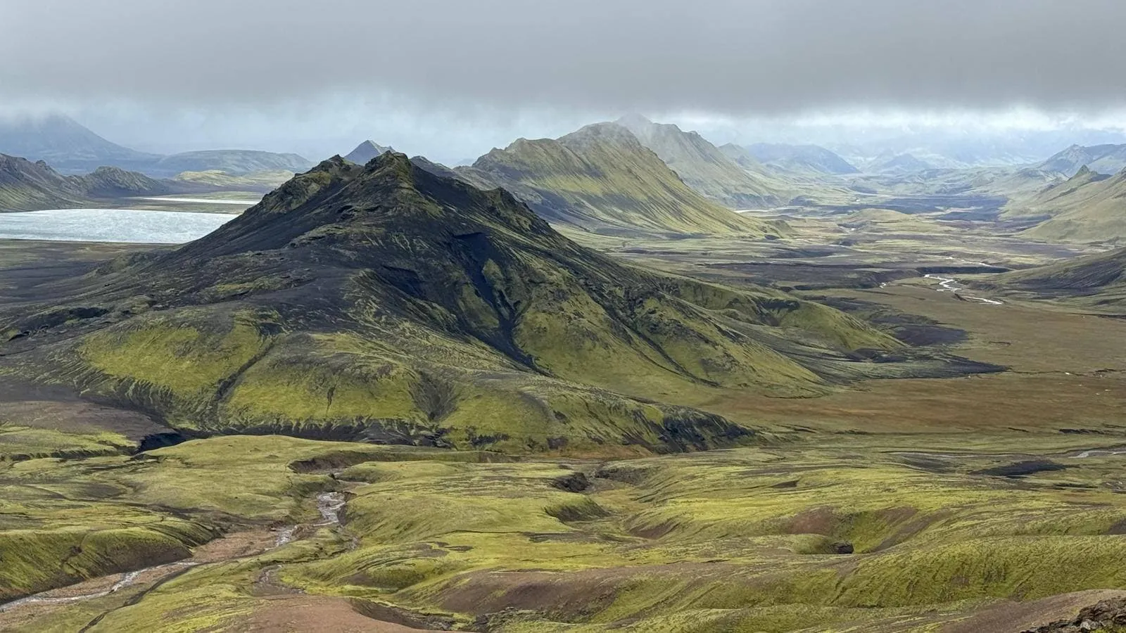
The Laugavegur Trail is located in the Southern Icelandic Highlands and connects the geothermal area of Landmannalaugar with the forested valley of Þórmörk in the South. Laugavegur means "The Way of the Water", and that is exactly what the trail does: it follows a stream.
The Fimmvörðuháls Hike is located in the southwest of Iceland - one of the busiest tourist regions in Iceland. The highlight of this hike is the opportunity to walk through a wide variety of landscapes in one day, or rather two days: starting at the ocean, past 26 waterfalls to tundra grasslands, then cross a volcanic plateau where some of the world's most recent volcanic activity has taken place.
On this 7-day trek, you will walk the Laugavegur Trail and the Fimmvörðuháls Hike, starting in Landmannalaugar and ending in Skógar. During the trek, you will enjoy the variety of Iceland, by passing the 'Swan Lake', black sand deserts, vibrant green mountains, crater lakes, and volcanoes. The trail is 85 kilometers, or 52.8 miles long. On this trip, we will arrange the accommodation for you and we will provide you with the walking notes necessary to complete the trail. Are you ready for this Icelandic adventure?
Why book through Bookatrekking.com?
You can walk the combination of the Laugavegur Trail and the Fimmvörðuháls Hike completely independently. However, putting together the right route including arranging all the accommodations can be complicated. Bookatrekking.com has warm contacts with all huts on the Laugavegur Trail and the Fimmvörðuháls Hike and we are happy to take that burden off your shoulders. Contact our Trekking Experts for free travel advice and arranging your combined Laugavegur Trail and Fimmvörðuháls Hike walk.
Route
What's the plan?Day 1: Arrival in Reykjavik
Today you will make your way to Reykjavik. Make sure you are well rested before starting the hike tomorrow!
Day 2: Landmannalaugar - Hrafnttinnusker
The first part of the route is the shortest in kilometers, but as the total height is almost 500 meters and this is the first day of the walk, many people find this part a bit exhausting. The weather is unstable in these areas, and it is often necessary to walk in the snow, which adds to the difficulty. The first section goes up to the lava field of Laugahraun, crosses it, and then goes downhill before going back up to the plateau just below Brennisteinsalda. Stop here and admire the beautiful views, the flora, the mountains, and the gaps in all the colors of the rainbow.
The route continues up to the plateau, where small ravines cut into the landscape as the rivers form the gentle mountain. The road ahead is all uphill, but not extremely steep. The next destination is Stórihver, a beautiful vegetation spot right next to a buzzing geyser where you can stop, rest your legs, and have a picnic from the provision box. From here it is about an hour's walk to the Höskuldsskáli hut near Hrafntinnusker.
Distance: 10.5 kilometers
Walking duration: 4-5 hours
Ascent: 500 meters
Descent: 90 meters
Day 3: Hrafnttinnusker - Álftavatn
The path from Hrafntinnusker runs along the slopes of Reykjafjöll. The area is a valley floor that is mostly flat, but there are a few ravines that need to be crossed with extra care as they are often half full of snow. If the weather and visibility are good, it is recommended to do the extra walk up to Háskerðingur, the highest mountain in the area, 1281m. The hike takes about 1-1.5 hours. Be careful, there are often glacier gorges in the ice just below the top. However, the top itself is usually snow-free in summer.
The trail now goes up and down through some canyons until it reaches the edge of Jökultungur, with incomparable views of the entire trail and the three glaciers Tindfjallajökull, Eyjafjallajökull, and Mýrdalsjökull. The way down along the Jökultungur is quite steep and rocky, so be careful. At the bottom of the Jökultungur awaits the Grashagakvísl River, which in some cases can be crossed by a snow bridge. If not, you have to cross the river on foot. The water in Grashagakvísl is fresh and good to drink. From here, the route to the cabin at Lake Álftavatn is easy.
Distance: 12.2 kilometers
Walking duration: 4-5 hours
Ascent: 80 meters
Descent: 560 meters
Day 4: Álftavatn - Emstrur
From Álftavatn the trail heads east over Brattháls and further east to Hvanngil. The Bratthálskvísl river has no bridge and must be crossed on foot, which is relatively easy in most cases. From the hill above Hvanngil, the view is magnificent. In Hvanngil, hikers can use the toilet facilities. Some hikers choose to spend the night here instead of in Álftavatn. From Hvanngil there is a short walk to the river Kaldaklofskvísl, which can be crossed by a footbridge. Just south is another river, Bláfjallakvísl, without a bridge. Be careful, especially during heavy rainfall the water can rise quickly.
The route now runs mostly along the main road until it reaches the river Innri Emstruá. This one has a bridge. Occasionally you have to walk through some water because there is an overflow that crosses the bridge. Just south of this, the path bends from the main road to the left and southwards to Emstrur, where the land is practical without vegetation. In dry weather, with strong winds, especially from the north, there can be a sand storm. The path lies between two mountains, called Útigönguhöfðar, and in about an hour you reach the Botnar hut in Emstrur.
Distance: 17 kilometers
Walking duration: 5 hours
Ascent: 200 meters
Descent: 260 meters

Day 5: Emstrur - Þórsmörk
From the huts in Botnar the trail leads east. Shortly afterward you come to a bridge over the river Syðri-Emstruá. The river flows into a narrow deep gorge that reaches as far as Entujökull. People with a fear of heights may have difficulty reaching and crossing the bridge. From there, the trail leads past Langháls and to the merging of the Markarfljót and Syðri-Emstruá rivers. It is recommended to walk to the edge of the gorge where the rivers meet, before walking south through Almenningar. Soon the path runs through two small ravines, Slyppugil and Bjórgil. In each of these ravines is a stream with drinkable water.
After climbing the last-named gorge, Bjórgil, the path leads to Fauskatorfur and gradually to an area with more vegetation, also called Úthólmar. The hill up from the river Ljósá is called Kápa or Overjas and is the last steep slope on the path. When the path goes down from Kápa, you have to cross the river Þröngá, which is not difficult in most cases but can be quite rocky. The river marks the border of Þórsmörk and now it is only a half an hour's walk through the pleasant forests of Hamraskógar until you arrive at Langidalur, Þórsmörk.
Distance: 16.2 kilometers
Walking duration: 6 hours
Ascent: 290 meters
Descent: 550 meters
Day 6: Þórsmörk - Fimmvörðuskáli Hut / Baldvinsskáli Hut
We then reach the flat Morinsheiði. The views you have from here are very picturesque. You look over glacier Mýrdalsjökull with the volcano Katla on top. The view of Heiðarhorn is also very nice.
You will cross Heljarkambur, a short ridge that connects Fimmvörðuháls and Morinsheiði (morins means a rusty red sheep). To make the path over Heljarkambur safer, a support chain is installed. The path follows to the hill Brattaföhn (föhn = snow), which in contrast to its name and due to recent climate changes, is usually snow-free in summer. You then will pass a stone tomb with three names. It is a memorial to the people who died there in 1970 from exposure to the sun.
You will walk through a lava field (Goðahraun) that was created during the volcanic eruption in spring 2010. During the same eruptions, the mountains Magni and Móði were formed. It is highly recommended that you hike to their summits. An information board about the eruption stands next to the mountains.
Ascent: 940 meters
Descent: 160 meters
Day 7: Fimmvörðuskáli Hut / Baldvinsskáli Hut - Skógar
When leaving the Hut, it is quite an easy walk at first. It follows the gravel road. When you reach the bridge over the river Skógá, you have walked about 6 kilometers. When walking down, make sure you don't miss the spectacular waterfalls you have in the back of you. You can see the end of the hike when descending the stairs on the right side of the waterfall Skógafoss.
Distance: 14.5 kilometers
Walking duration: 5 hours
Ascent: 20 meters
Descent: 980 meters
Day 8: Skógar - Reykjavik
After breakfast, you will take the bus back to Reykjavik where you can wander through the city the rest of the day.
Day 9: Departure from Reykjavik
After today's breakfast, our services and your combined hike in Iceland will be over. Have a safe trip back home!

What's Included
Included:
√ Booking the huts
We will take care of arranging accommodation for you. We will also provide you with a detailed itinerary for every stage and instructions on how to get to the trailhead.
√ Accommodation
We will arrange your accommodation on the Laugavegur Trail and the Fimmvörðuháls Hike in huts. The accommodation will be in shared rooms. Before and after the hike, you will spend the night in a hotel or B&B in Reykjavik.
√ Accommodation in Reykjavik
We will book a hotel or B&B for you in Reykjavik, before and after the trek.
√ Transfers
Once in Reykjavik, you will have to take the bus to Landmannalaugar, where the hike starts. We will book the bus for you, so the tickets are included in this package. You will also receive information on which bus you have to take and a timetable.
Excluded:
× Airfare and Visa
You have to make your way to Reykjavik. The total amount is exclusive of flights to Reykjavik.
× Meals
Meals are not included in the package, you will have to bring it yourself. You can use the kitchen with all its facilities in each hut.
× Baggage Transfer
Baggage transfer is not included in this trek. However, there is a possibility to have your baggage transferred along the way, for an additional charge.
× Travel Insurance
Your international travel insurance is your own responsibility. Discuss your itinerary with the insurance company before your trek.
× Personal expenses
Personal expenses such as souvenirs, drinks, and other similar expenses are for your own account.
Accommodation
AccommodationBefore and after the hike, you will spend the night in a hotel or B&B in Reykjavik.
On the Laugavegur Trail, you will spend the night in typical Icelandic huts. There are six huts along the route, all owned by Ferðafélag Íslands (Iceland Touring Association, FÍ). In Landmannalaugar, there are good facilities and there is a dormitory for 78 people. In Hrafntinnusker, 52 people can sleep, and in Álftavatn 72 people can sleep in the huts. In Hvanngil there is room for 60 people and the same number goes in the Botnar hut in Emstrur. Þórsmörk offers a large and spacious chalet with room for 75 people.
On the Fimmvörðuháls Hike, you will spend the night in a typical Icelandic hut. There are three huts along the route, all owned by Ferðafélag Íslands (Iceland Touring Association, FÍ). The first hut is Básar Hut, and has room for 83 people. This hut is only 5 kilometers away from Þórsmörk. The second hut is Fimmvörðuskáli, which is located next to the main trail. This hut has room for 18 people. The third hut is Baldvinsskáli, which is located at the top of the main trail. This hut has room for 20 people. Please note, that the second and third hut are relatively small, so they will be fully booked soon. If this is the case, we will book the first hut for you. You will then have one relaxed day of walking. In Skógar you will spend the night in a hotel, with a private room. The next morning, you will take the bus back to Reykjavik.
Keep in mind that the next available accommodation in the Icelandic highlands may be many hours' walk or drive away, so plan your trip in advance. You must bring your own sleeping bag, as this is not provided. In the bigger huts, you can expect both running water and water toilets, but in some smaller huts, you will have to fetch water from a nearby stream and use an outdoor toilet.
In most huts along the Laugavegur Trail, it is possible to buy some supplies, such as dried food for backpacking, soft drinks, and bars.
There are some main rules, that you must follow. Hygiene, cleanliness, and consideration for fellow travelers are very important. These hut rules are made to ensure a comfortable stay for everyone.
- If the manager is available, please discuss your reservation with him/her, where to sleep, and specific hut rules
- Rest times are from midnight to seven o'clock the next morning
- No shoes in the hut. Please leave your hiking boots in the hallway
- Smoking in the huts is strictly forbidden
- Leave the cooking area clean and tidy
- Add water to the big pot on the kitchen stove, if necessary
- When leaving, make sure the hut is clean and tidy
- Don't forget to pay for the facilities
- Help to keep the environment clean by not leaving your rubbish behind
- You hike in Iceland to experience nature. Remember: clean environment = beautiful nature!

Packing list
Packing ListIceland's weather is completely unpredictable and constantly changing. The only predictable thing about Icelandic weather is the wind, as it is almost always blowing. For example, it is not unusual to experience a snowstorm in July or dense fog when the weather forecast was sunny! This is why walkers should always carry the same basic equipment in their rucksack, regardless of the season, weather, or length of the walk. This basic equipment includes navigation equipment (GPS, map, and compass) and wind and waterproof clothing. Please note that when staying in cabins in Iceland, you will need to bring both a sleeping bag and your own food, as you cannot buy a ready-to-eat meal in the cabins.
Essentials:
- Hiking boots (broken in)
- Hiking socks
- Base layer tops - ideally thermal
- Mid-layer tops (e.g. fleece)
- Trekking trousers
- Hat for warmth or shade
- Gloves
- Waterproof jacket
- Waterproof trousers
- Casual clothing & footwear for evenings
- Nightwear and underwear
- Water bottle
- Sunglasses & sunscreen
- Toiletries
- Meals
- Sleeping bag
Extras:
- Small first aid kit
- Blister plasters
- Insect repellent
- Camera and charger
- Map and compass
- Whistle
- Book to read
-Energy snacks
- Walking Sticks
FAQ
FAQWhat is the best season?
The Laugavegur Trail and the Fimmvörðuháls Hike are only accessible during the summer months, from June to September. In these months, you will find the least snow on the trails. Also, the bus that takes you to Landmannalaugar and from Skógar only runs in these months.
How do I get to the starting point?
The best way to get to Landmannalaugar, the starting point of this combined hike is by bus. There are two companies that sell tickets for their adventurous bus ride. Adventurous? Yes, it is definitely not a city bus ride. To get to Landmannalaugar, you follow gravel roads and cross a river. The bus is of course well equipped for this.
How do I get back to Reykjavik?
The bus that brought you from Reykjavik to Landmannalaugar, will also bring you back. You will get on the bus in Skógar. From here, the bus will take you in approximately 4 hours back to Reykjavik. The bus from Skógar to Reykjavik only goes in the morning. Therefore, after the walk, you will first spend the night in Skógar in a hotel before going back to Reykjavik.
Direction of the Laugavegur Trail and Fimmvörðuháls Hike
The Laugavegur Trail normally can be walked both ways, however, due to the popularity of the trail, it is a one-way, traditional route, starting in Landmannalaugar and ending in Þórsmörk. Therefore, when walking the Laugavegur Trail in combination with the Fimmvörðuháls Hike, we will start in Landmannalaugar and end in Skógar.
Where to find maps?
Of course, there is nothing better than a real old-fashioned map, possibly made of paper. You can buy maps of both hikes in almost every bookstore in Reykjavik.
Safety
SafetyWalking the Laugavegur Trail combined with the Fimmvörðuháls Hike is perfectly safe. However, it is important that you hike between the months of June and September. If you go outside these months, the paths are covered with snow and it is a lot less safe to hike these trails.
Icelandic Emergency Number: 112
COVID-19
COVID-19- Don't go on your hiking trip if you have symptoms.
- Not all the accommodations are allowed to operate at full capacity yet, so make sure you book your stay in advance.
- Keep your distance and hygiene.
- Use disinfectants and hand sanitizers.
How to Book
How to Book?On Bookatrekking.com you can find and compare the adventures of your dreams. Is this trekking your match? In that case, you can proceed with your booking. At Bookatrekking.com you make a deposit of 30% of the total amount. In the case of this trek, we will check the availability at the respective accommodations for you. There are two possible outcomes:
√ There is availability
We go ahead and make all necessary arrangements for your trip. Once confirmed, we will send you a confirmation and your personal hiking guide. The remaining 70% must be paid at least two (2) weeks before the start of the trekking.
X There is no availability
If there is no availability, we will look for other starting dates or another trekking in agreement with you. Are there no other options for you? Then your deposit of 30% will be refunded.
Cancellation Policy
If all the accommodations of this trekking are booked and confirmed, you will lose your deposit of 30% at all times. If you cancel within 14 days of your start date, you will lose your full booking amount.
Is it not quite clear yet or do you have questions? Please contact us via support@bookatrekking.com. We are happy to help you.
Gallery
These treks you might like
Elbrus Summit, Northern Route
Operated By Mountain TerritoryThe ascent from the north is perhaps the most picturesque of all the routes to the top of Mount Elbrus. There are no lifts or hotels on the....
Full Mullerthal Trail (Route 1, 2 & 3)
Operated By Bookatrekking.com TripsThere is no better way to discover 'Little Switzerland' than by hiking the full Mullerthal Trail. During this trek, you will complete Routes...
Ghorepani - Poonhill - Ghandruk Trek
Operated By Nepal Eco AdventureThis short trail offers you a wonderful trekking experience in the Himalayas. This is the best option to experience the Himalayas, its...
2-Day Doi Inthanon Hilltribe Trail
Operated By Ethnic Hill Tribe Eco TrailsOn our 2 day trek, we will hike 4 hours along a non-touristic trail through the rainforest. Sleep in a Karen Hilltribe village and get to...
Classic Inca Trail Trek
Operated By TreXperienceThe Inca Trail to Machu Picchu is a once in a lifetime experience and an opportunity not to be missed. It is one of the world’s...
Rinjani trek to the Summit (recommended for experts)
Operated By Herman TrekkerJoin us in this fast ascent to the top of mount Rinjani. This trek to Mount Rinjani's summit (3726 m) via Sembalun village is recommended...