Via Selvaggia Sardinia

Duration: 8 days
Trails: T3 trails
Distance: 15 - 20 km / 9 - 12 mi per day
Ascent per day: 500 - 1000 m / 1640 - 3281 ft ascent per day

> Hike across the superb Supramonte range
> Spend the nights in rural hotels and village guesthouses
> Walk along the dramatic east coast with white sand beaches and vertical cliffs

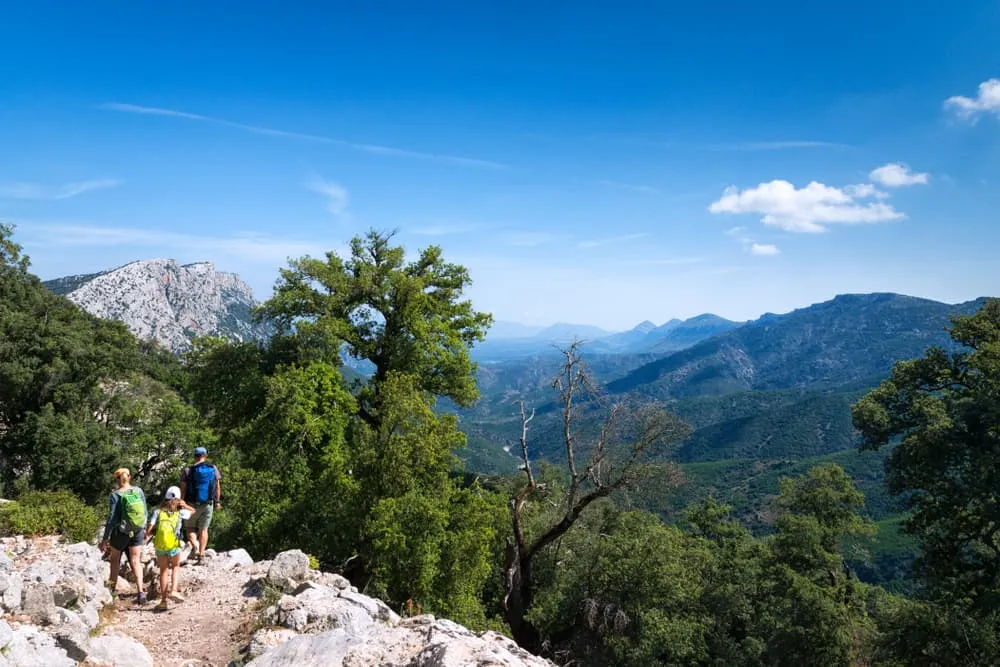
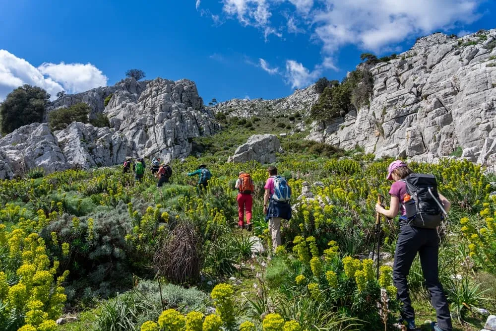
Sardinia has many excellent choices when it comes to hiking journeys. Most of the time it's either a route through the mountainous interior, or along the coast. Why not have both? We created a 6-day hiking route that combines the very best Sardinia has to offer. It's a wild walk, as the name of this trail Via Selvaggia Sardinia in Italian suggests. You will follow small pathways across the Supramonte range, continuously surrounded by fragrant shrubs, craggy peaks and if you're lucky wildlife like the mouflon. The route briefly touches the east coast, stunning seascapes guaranteed!

The Via Selvaggia Sardinia is not just about hiking in pristine nature. The pace of life in the centuries old villages is slow, just what you need after a long day on the trail. Wind down and enjoy the incredible Sardinian cuisine. You don't have to worry about the logistics of reserving the posadas (local guesthouses). We'll take care of that for you, so all you have to do is enjoy this unforgettable adventure.

Itinerary

Day
1

Arrival Fonni

Fonni is the highest town in Sardinia and a great place to gear up for your trek across the Supramonte range. Check out the beautiful murals!

B&B La Dolce Sosta (Fonni)

Info
B&B La Dolce Sosta (Fonni)
Day
2

Passo di Correboi - Passo Ghenna Silana

Duration: 07:50 h
Distance: 23 km / 14.3 mi
Ascent: 830 m / 2723 ft
Descent: 1070 m / 3510 ft
From Fonni you'll take a taxi to one of the highest mountain passes in Sardinia, Passo di Correboi (1246 m). From here you head east into the Supramonte mountains. You stay at higher altitudes, though the trail goes up and down through barren rocky terrain and pine forests. Make sure to carry enough water for the day (at least 3 liters)! You finish the day at another mountain pass, Passo Ghenna Silana.

Hotel Gorropu (Passo Ghenna Silana)

Info
Hotel Gorropu (Passo Ghenna Silana)
Day
3

Passo Ghenna Silana - Rifugio Gorropu

Duration: 06:00 h
Distance: 20 km / 12.4 mi
Ascent: 300 m / 984 ft
Descent: 940 m / 3084 ft
From your accommodation on the Ghenna Silana pass, you descend in a northern direction towards the Flumineddu river. When you reach the river you'll be at the entrance of one of the deepest gorges in Europe and a truly iconic landmark on Sardinia: the Goroppu Canyon. On either side the limestone walls are 400 meters high and at some places, it's as narrow as 5 meters. At the gorge you'll cross the river again and you follow the Flumineddu downstream through the forest. Close to the hill called Monte Tundu, you cross the river again and continue across farmland to the brilliant Rifugio Gorropu.

Rifugio Gorropu (Dorgali)

Info
Rifugio Gorropu (Dorgali)
Day
4

Rifugio Gorropu - Cala Gonone

Duration: 05:20 h
Distance: 15.3 km / 9.5 mi
Ascent: 680 m / 2231 ft
Descent: 790 m / 2592 ft
From Rifugio Gorropu, you'll traverse the coastal mountains via Dorgali. If you're up for it, you can climb the 917 hill Monte Tului. Enjoy wonderful views across the Mediterranean Sea. Just before you arrive in your sweet spot for the night just south of Cala Gonone, you can go for a dip at a secluded picture perfect little beach. It's a bit of a climb to the accommodation, but the views are worth it.

Hotel Turismo Rurale Villa Maria Caterina

Info
Hotel Turismo Rurale Villa Maria Caterina
Day
5

Cala Gonone - Dorgali

Duration: 07:20 h
Distance: 20.3 km / 12.6 mi
Ascent: 1100 m / 3609 ft
Descent: 960 m / 3150 ft
More seascapes today! You'll pass the coastal town of Cala Gonone, which has a great beach and it's tempting to stay here the rest of the day. However, it a long hiking day and north of the town you'll ascend the steep coastline to the ridge that connects with its highest point Monte Bardia (881 m). From this point you'll enjoy magnificent views across the Supramonte mountains, Dorgali and the central east coast of Sardinia. A steep descent takes you to Dorgali, a charming village that's your place for the night.

B&B da Miranna (Dorgali)

Info
B&B da Miranna (Dorgali)
Day
6

Dorgali - Oliena

Duration: 07:45 h
Distance: 23.5 km / 14.6 mi
Ascent: 900 m / 2953 ft
Descent: 860 m / 2822 ft
Although it's a long day, most of the route is very doable. The first half you'll mostly walk on country tracks without too much climbing or descending. Around half-way, after you cross the river Fiume Cedrino, the trail goes up towards the barren ridge line of the northern Supramonte. Stay below the ridge, as you pass several cave systems underneath the impressive rock walls. You'll contour the hillside in a roughly westerly direction until the final descent to the pretty village Oliena.

B&B Corte San Lussorio (Oliena)

Info
B&B Corte San Lussorio (Oliena)
Day
7

Oliena - Orgosolo

Duration: 06:20 h
Distance: 15.2 km / 9.4 mi
Ascent: 1120 m / 3675 ft
Descent: 1040 m / 3412 ft
Head back up the way you came yesterday for 1.5 km until you reach the trail junction. Turn right (south) and ascend up the ridge that eventually reaches the highest point in the Supramonte range, Monte Corrasi (1463 m). Take a small 5 minute detour to climb to the highest point. Descend the ridge for a couple of kilometers and turn right, descending further towards the Oliena - Orgosolo road. There's a fantastic spot where you will spend your final night.

Affittcamere Jannas (Orgosolo)

Info
Affittcamere Jannas (Orgosolo)
Day
8

Departure from Orgosolo

It's time to bid farewell to the Supramonte mountains, looking back at a brilliant hike across some of Sardinia's most beautiful landscapes.
See entire itinerary

Included

  • Accommodation

    We will arrange your accommodation on the Sardinia in hotels, inns, and guesthouses. Accommodation will be private in single, double or twin rooms and with en-suite bathroom where possible.

  • Full travel guide

    We will send you on your way with a digital travel guide which includes a route description, interactive Sardinia hiking maps, and the most important information applicable to your trek.

  • Baggage Transfer

    This trek includes the transfer of your luggage throughout the entire Sardinia trek. Your bags will be picked up every morning from the hotel lobby and will be driven to your next next accommodation. Baggage transfers allow you to travel lighter during the day and enjoy the walk in a more relaxed manner.

  • Breakfast

    Breakfast is, if possible, included in this trek and it will be provided every morning at your accommodation.

Excluded

  • Traveling to and from

    You have to make your own way to the starting point. The total amount does not include personal transport. This also applies to any transport from the end point of your trail.

  • Transfers

    If you require any form of public or local transport during the trek, it is not included in the package unless stated otherwise. This applies to taxis, buses, cable cars, gondolas, and similar services.

  • Travel Insurance

    Your international travel insurance is your own responsibility. Discuss your itinerary with the insurance company before your trek.

  • Lunch and Dinner

    Breakfast is, if possible, included in the price of the trek. You can get lunch and dinner at the shops, hotels, and restaurants along the way.

FAQ

  • What and Where Is Sardinia?

  • When Is the Best Time for Hiking in Sardinia?

  • Are the Sardinia Hiking Trails Difficult?

How to Book

  • Booking

  • Availability

  • Cancellation policy

Just for You