Half Alta Via 2
Bookatrekking.com Trips - 7 days
-
Regular days with
- 10 - 15 km per day
- 500 - 1000m ascent per day
- T3 Trails
Overview
> The first 7 stages of the notorious Alta Via 2> Spend the night in cozy Italian Rifugios
> We book your accommodation
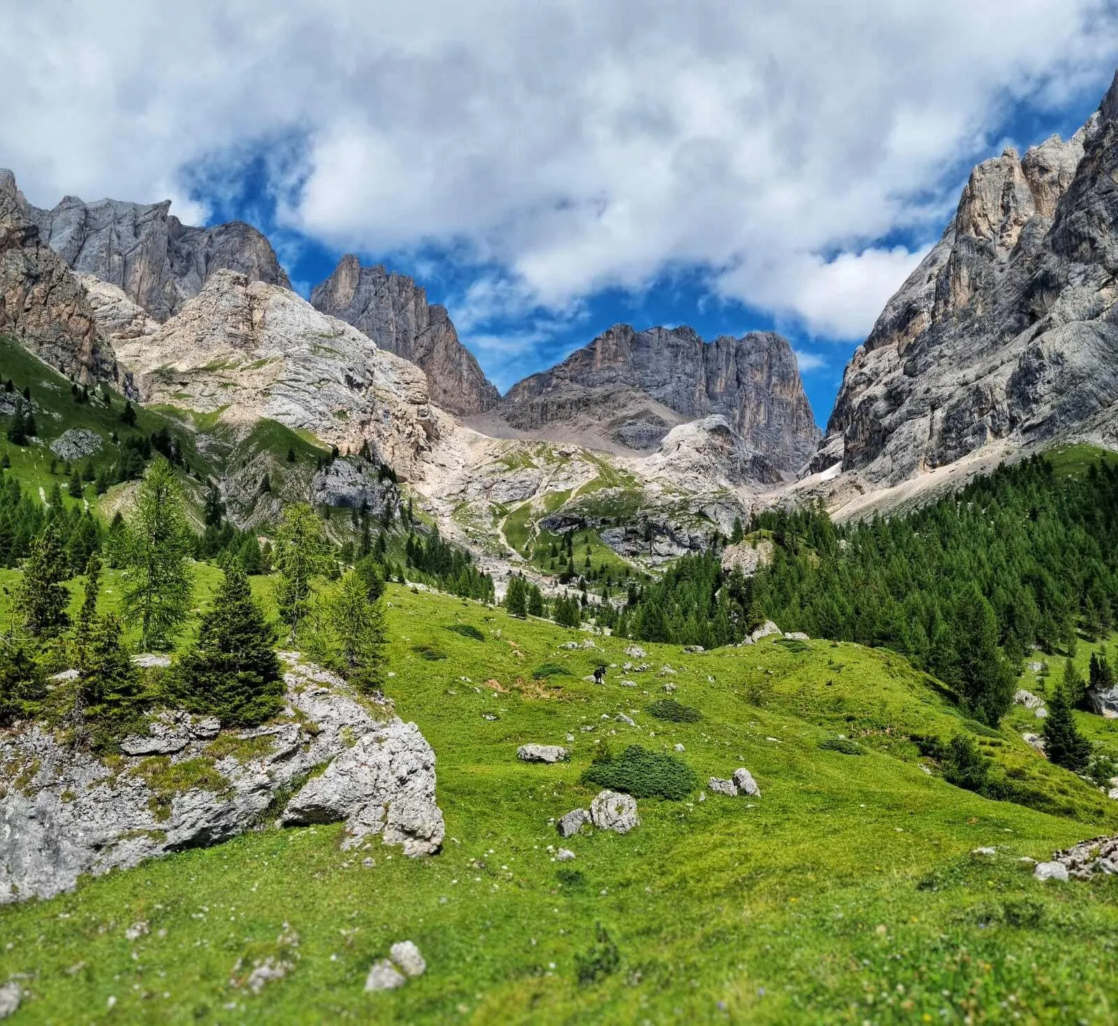
The Alta Via 2 is one of the 6 famous Alta Via treks in the Italian Dolomites. If you are looking for your next challenge, the Alta Via 2 is the perfect match. This trek is full of adrenaline and only suitable for experienced trekkers with surefootedness, experience in the mountains, and a head for heights. The Alta Via 2 includes sharp ridges, Via Ferratas, and steep slopes. Are you brave enough to face it?
The entire Alta Via 2 can be completed in 11 to 14 days. This 7-day option covers the first somewhat less-technical half of the Alta Via 2, from Brixen / Bressanone to San Pellegrino. Don't be mistaken, the trek still offers challenging trails, the possibility of conquering Via Ferratas and accommodation in the best Italian mountains huts. Don't forget to soak up the views and the fantastic Northern Italian cuisine.
Why book with us?
Route
What's the plan?Stage 1: Bressanone - Rifugio Plose
The starting point of the Alta Via 2 is at the station of the cable car in S. Andrea. It goes up to Valcroce and from here, path n° 7 starts towards the Rifugio Plose. A variant for the more trained hikers is to walk up to the Rifugio Plose, starting directly from S. Andrea instead of taking the cable car. The path is quite steep but well maintained and while walking you can enjoy the Dolomites and the flora and fauna of the Puez-Odle nature park. The Plose hut is the first stop on the Alta Via 2 and it is located 2447 m above the city of Bressanone.
Walking time: 1.5 hours from the Cable Cars / 4 hours from S. Andrea
Ascent: 380m / 1500 m
Accommodation: Rifugio Plose
Stage 2: Rifugio Plose - Rifugio Genova (Schlüterhütte)
From Rifugio Plose, following path n° 4 and the signs of the Alta Via 2, you walk downhill for about 2 hours to the Rodella pass. From here, after about 30 minutes, you will find yourself in front of the fork of Sass Putia - the most challenging part of this stage of Alta Via 2. The Forcella della Pùtia appears in the background as an immense gateway to the enchanted kingdom of the Dolomites. To reach it you have to overcome an uphill difference in altitude of 500 meters. At first, the path is gentle, but it then follows some steep switchbacks (often with snow, even at the beginning of July) that climb up to the Forcella della Pùtia (Peitlerscharte), at 2357 meters. From the fork, follow path no. 4 southwest, flat and panoramic, to the Poma Pass (Kreuzkofeljoch, 2340 m), from which you can already see the Rifugio Genova, at 2297 m, to the southwest (30 minutes from Sass de Putia).
Walking time: 5 hours
Ascent: 540 m
Descent: 660 m
Accommodation: Rifugio Genova
Stage 3: Rifugio Genova - Rifugio Puez
From the Rifugio Genova-Schlüterhütte, at 2297 m, take path n. 3 which, after a stretch to the east, turns to the south along the eastern side of the Bronsoi with a splendid panorama of Odle and Puez. This is an area of great geological and floristic interest.At the altitude of 2421 m, the path turns to the southwest, passes above Munt de Medalges in the Natural Park Pùez-Odle, and reaches the Fùrcia de Medalges (Kreuzjoch), at 2293 meters. Path no. 3 then runs east of the Campillerturm and Sass da l'Ega (Sasso dell'Acqua-Wasserkofele) and then crosses the long Longiarù ridge. Go over the ridge, cross it up to a junction at an altitude of 2389 meters. Then climb up to reach the Fùrcia dla Róa (Forcella della Rova-Roascharte), at 2617 meters. This saddle divides the Odle Group in the west from the Pùez Group in the east. Attention: at the beginning of the season it is possible to find hard snow in the gully and an ice axe or at least half crampons would be useful.
Continuing along the route you descend southwards to a junction at an altitude of about 2500 m in a large debris basin. Here you leave path n. 3, which descends to the right (south-west) and join path n. 2. Path n. 2 will take you east to Fórces de Siëles, at 2505 meters. After crossing the fork, you will find yourself in front of thin pastures. The Sassonghér appears in the distance, to the east. Now, path no. 2 turns to the north-east and becomes a thin path carved into the rock. The trail is not difficult and there are some metal ropes to help you. Then, after a flat stretch, the path descends eastwards through the wide grassy plain of Munt de Pùez, makes a wide Z, and heads eastwards once more up to the nearby Pùez Hut, at 2475 meters.
Walking time: 5.5 hours
Ascent: 800 m
Descent: 640 m
Accomm0dation: Rifugio Puez
Stage 4: Rifugio Puez - Rifugio Franco Cavazza al Pisciadù
From Rifugio Pùez (Puezhütte, 2475 m), follow path n° 2 southeast and cross the vast plateau of the Pùez where, in case of fog, you must look out for the signs. After the crossroads at an altitude of 2104 m, continue southwards to reach the Forcella de Ciampëi (or Somafùrcia, 2366 m). From here to Passo Gardena, path no. 2 will always go in a southwest direction. From the fork, you go up a little bit, until you reach Lech de Crespëina (Lake Crespèina-Crespeina See). From the small lake, with a steep ascent, you reach the Forcella de Crespëina, at 2528 meters. You then descend steeply and finally make a final climb through loose rock to the Forcella Cir (or Dantes les Pizes-Cirjoch, 2469 m).
From here on it's all a succession of gentle ups and downs, forks, boulders, small towers, and pastures until you reach the wide Dolomite saddle of Passo Gardena (Grödner Joch, 2121 m). It is best to leave the traffic and noise at Passo Gardena and trek on to the peaceful Rifugio Pisciadù. From the pass, follow path no. 666. After a while, path n. 666 climbs a narrow and rocky valley until it widens. Here you take the left and climb up through debris and loose rock. There may be some snow in this section of the trail (section equipped with fixed ropes). The trail then turns to the south-east and after a short descent, you reach the "Franco Cavazza" Rifugio at Pisciadù, 2585 meters.
Walking time: 5 hours
Ascent: 660 m
Descent: 560m
Accommodation: Rifugio Franco Cavazza al Pisciadu
Stage 5: Rifugio Pisciadù - Rifugio Castiglioni Marmolada
From Pisciadù Hut take path n. 666 southwards, along the eastern shore of the lake. Above the Val de Tita, there are two possibilities: an easier path, or a section equipped with fixed ropes. The path then continues on gravel and sometimes on patches of snow up to a saddle. The trail then goes up to Dante's Altipiano del Sella where, in case of fog, you must follow the signs very carefully. You then turn southwards, cross the plateau, and descend to Forcella d'Antersass, at 2861 m, where path n. 666 ends. You now start walking on path no. 647.
Continue south to the top of the Antersass (Zwischenkofel, 2907 m). You can circumvent the summit through the path on the right, but if the weather is nice it is worth taking a look from the top. You will then descend to Boè Hut (Bambergerhütte, 2871 m). From Boè Rifugio take path n. 627 up to Forcella Pordòi Rifugio (2829 m) from where you can enjoy a splendid panorama.
At the rifugio, a wide and steep scree slope begins; you can follow the numerous switchbacks, or let yourself "slide" on the soft gravel. Finally, the path leads down to Passo Pordòi, at 2239 meters. From Passo Pordòi, take path 601 southwards, towards a chapel. Following the eastern slope of Sass Beccè, the trail leads to Rifugio Baita Fredarola, 2370 m.
From Fredarola Rifugio, the path bends eastwards to enter the Vièl dal Pan (Path of Bread), an ancient path between the Val di Fassa and the Agordino. The path is wide and panoramic, especially on the Marmolada that stands out gigantic in front of it. At about halfway along the path there is the Rifugio Vièl dal Pan, 2432 m. From Rifugio Viel Dal Pan follow the path up to the junction with path n. 698. Follow path n. 601 to the south, then turn west along the steep meadows, until you reach the nearby Rifugio Castiglioni Marmolada (2044 m).
Walking time: 7 hours
Ascent: 710 m
Descent: 1230 m
Accommodation: Rifugio Castiglioni Marmolada
Stage 6: Rifugio Castiglioni Marmolada - Rifugio Contrin
From Rifugio Castiglioni Marmolada descend to Pian Trevisan (1681m) along the "Via Neva" (path 605), an old mule track used in the past by tourists and porters to reach the top of the Marmolada. Continue through the forest to the village of Penia (1554m) and immediately after the village, ascend on the left to Val Contrin (path 602) via "Locia de Contrin" (1736m) to the mountain hut of the same name (2016m).
Walking time: 4 hours
Ascent: 490 m
Descent: 540 m
Accommodation: Rifugio Contrin
Stage 7: Rifugio Contrin - Passo San Pellegrino
Behind the Rifugio Contrin, at 2.016 m, take path n. 607 on the right. After passing a stream, cross the Lasté de Contrin until you reach a plateau. Here you go left, going up to a back of mountain rocks that divides two small valleys. Follow the trail until you reach a large sign that marks the fork with path n. 612. Continue along the steps that take you to the Cime Ciadine. Finally, you reach the saddle of the Cirelle Pass at 2,682 m. Descend the opposite slope towards Val da la Tas-cia. On the military road, cross the plateau of the Busc da la Tas-cia and then descend through switchbacks towards the valley where you will find Rifugio Fuciade, at 1,972 m.
From Rifugio Fuciade, a dirt road leads along the Fuciade valley. After 20 minutes you will reach the main road, which will lead you to Passo San Pellegrino.
Walking time: 4.5 hours
Ascent: 680 m
Descent: 780 m
What's Included
Included:
√ Booking the huts
We will take care of arranging accommodation for you. We will also provide you with a detailed itinerary for every stage and instructions on how to get to the trailhead.
√ Accommodation
We will arrange your accommodation on the Alta Via 2 in mountain huts, also know and Rifugios. There are several options to choose from along the trail. We have selected the mountains huts on our trek based on the length of each stage and recommendations from trekkers who have done the Alta Via 2 before us.
√ Halfpension
Most huts along the Alta Via 2 include dinner and breakfast. We will arrange this for you as well. This allows you to travel lighter and have one less thing to worry about. Bear in mind that lunch is not included, but it can be purchased at the Rifugios.
√ Official Cicerone Hiking Guide
This offer includes the 4th revised edition of Cicerone bestseller Trekking in the Dolomites - Alta Via 1 and Alta Via 2 with Alta Via 3 - 6 in outline written by Gillian Price.
Excluded:
× Airfare and Visa
You have to make your way to Brixen / Bressanone. The total amount excludes flights to Italy.
× Transfers
Once in Italy, you will have to make your way to the trailhead at Brixen. We will provide the instructions and assist you with how to get there. The bus tickets are not included. The transfer back to Brixen at the end of the trek is not included either.
× Accommodation before and after the trek
Before and after the trek you have to take care of your own accommodation.
× Travel Insurance
Your international travel insurance is your own responsibility. Discuss your itinerary with the insurance company before your trek.
× Lunch
Half-board is included in the price of this trek. Lunch, however, is not. You can get something to eat at the mountain huts along the way.
× Personal expenses
Personal expenses such as souvenirs, drinks, and other similar expenses are for your own account.
Accommodation
AccommodationAlong the Alta Via 2 you will spend the night in mountain huts along the route. The huts or Rifugios on the Alta Via 2 offer sleeping accommodations, that is, in a shared room. Most huts also have half board (breakfast & dinner) included in their price. The cabins on the Alta Via 2 are very well equipped and comfortable. Despite the differences in size and accommodation options, all huts offer a good shower, a good night's sleep and tasty local food.

One of the huts where you will stay along the way is Rifugio Pisciadu.

Packing List
Packing ListPacking is key, always. For the Alta Via 1 and 2, you will need pretty much the same equipment, except for the Via Ferrata sections on the Alta Via 2 where you might want to add some extra safety items to your bag. Here are our suggestions:
Clothing
- Convertible lightweight, quick-drying trousers.
- Lightweight, quick-drying t-shirts
- Good walking socks
- Lightweight fleece layer
- Waterproof jacket
- Thermal jacket
- Cotton leggings and t-shirt to wear in the huts in the evenings.
- Gloves
- Sun hat
- Good quality walking boots
- Flip flops for the huts
Equipment
- Walking poles
- Sleeping bag and liner
- Travel towel
- Water bottle
- Dry bag
- First aid kit
- Sunscreen
- Toiletries
- Phone charger
- Guide book and maps
Via Ferrata (optional)
- Helmet
- Harness
- Carabiner
FAQ
FAQ
Where is the Alta Via 2?
The Alta Via 2 is a 160 km hiking trail in the Dolomites in northeastern Italy. The Dolomites span the provinces of Belluno, South Tyrol, and Trentino. The name of this group of mountains comes from the French geologist who discovered the Dolomite mineral, Deodat de Dolomieu, in 1791. Most of the peaks of this mountain range go above 3,000 meters, and the highest peak at 3343 meters is Marmolada Peak.The route begins in Bressanone, also known as Brixen, and ends in Croce d'Aune. This popular hiking trail is part of a larger system of trails. In total, there are 6 Alta Vias in the Dolomites, all with different lengths and levels of difficulty. Perfect for your walking holidays in Italy.
What is the best season for the Alta Via 2?
The season of the Alta Via 2 begins June 15 and ends in late September. At Bookatrekking.com we regularly receive requests to start earlier. Is this possible? Early in the season at higher altitudes, you can still find a lot of residual and compacted snow. It is wise to wait until the last week of June before you start. This way you can be almost sure that the snow is cleared from the trails and the paths are more passable and above all safer. For the same reason, it is advisable to go no later than mid-September. Most huts close already in the third week of September and also fickle weather in the mountains can cause dangerous situations.
How do I get to the start of the Alta Via 2?
The Alta Via 2 can be hiked in both directions, although most trekkers choose to start from the north and make their way southwards. From the north, the trail starts in Bressanone, also known as Brixen, and ends in Croce d’Aune.
Brixen
If you are taking a plane to get to your Alta Via 2 adventure, the closest International Airports to Brixen are Venice and Innsbruck. If you live close by, Brixen is on the A22, the main corridor across the Alps in this region, which makes it easily accessible by car. Also, Bressanone can be easily reached by train or bus all year round.
Croce d’Aune
During the summer months, Croce d’Aune can be reached with regular Dolomiti buses to and from Feltre. After mid-September, however, busses are less frequent. The drive from Feltre to Croce d’Aune is quite short. If there are no busses at the time of your visit, you could take a taxi for about EUR 20,-.
Can I camp on the Alta Via 2?
We'll get right to the point: wild camping is not allowed on the Alta Via 2. Hikers are required to spend the night in mountain huts, rifugios in Italian. The good thing about spending the night in the huts is that you don't have to bring a tent, cooking kit, and the food for the 13 days. The rifugios vary in size and accommodation options, but they all offer a shower, a good night's sleep including half board with tasty local cuisine.
What is a Via Ferrata?
A via ferrata, in English iron path, or in German Klettersteig, is a protected climbing path with cables, ladders and iron supports attached to rock walls. There are several famous Via Ferratas in the world, the highest of which, on Kota Kinabalu, is one of them! The purpose of the Via Ferrata is to help trekkers on their way up. However, the Via Ferratas on the Alta Via 2 had a different purpose when they were built. During World War I, the Dolomites were the scene of battles between the Italian and Austro-Hungarian forces. The Via Ferratas were installed during those years to allow troops faster access to the front lines.
Safety
SafetyThe Alta Via 2, as well as all the other Alta Via trails on the Dolomites, are safe. The Alta Via 2, though, requires some previous experience and some extra equipment, but the trail itself is clearly marked and signposted. The route is marked with red and whites paint splashes, cairns, and the occasional triangle symbol with a “2” inside it, the logo of the Alta Via 2. As explained above, the Alta Via 2 has some Via Ferratas or Iron Roads along the way. Although there are no special requirements when it comes to equipment, we do recommend carrying along a helmet, harness, and carabiners on the Alta Via 2. Having these items, despite not being required, will help you to feel more comfortable on the route and to prevent silly accidents which may force you to end your adventure before reaching the finish line. Safety first!

COVID-19
Covid-19
The Corona pandemic has had its grip on us, and mountain huts in the Alpine region have had to take several preventive measures over the past two years. In the meantime, the first relaxations in the Alps are noticeable, yet it is definitely still a factor to take into account. Some Covid restrictions that are worth mentioning:
- Don't go to the huts if you have symptoms!
- Not all mountain huts are allowed to operate at full capacity yet, so make sure you book your stay in advance.
- To be on the safe side, always take a mouth mask with you.
- In some mountain huts it is still compulsory to bring your own sleeping bag, in others a sheet bag and pillowcase are sufficient. Your personal travel guide will tell you which rules apply to your route.
- Bring your own towel
How to Book
How to Book?
On Bookatrekking.com you can find and compare the adventures of your dreams. Is this trekking your match? In that case, you can proceed with your booking. At Bookatrekking.com you make a deposit of 30% of the total amount. In the case of this trek, we will check the availability at the respective accommodations for you. There are two possible outcomes:
√ There is availability
We go ahead and make all necessary arrangements for your trip. Once confirmed, we will send you a confirmation and your personal hiking guide. The remaining 70% must be paid at least two (2) weeks before the start of the trekking.
X There is no availability
If there is no availability, we will look for other starting dates or another trekking in agreement with you. Are there no other options for you? Then your deposit of 30% will be refunded.
Cancellation Policy
If all the accommodations of this trekking are booked and confirmed, you will lose your deposit of 30% at all times. If you cancel within 14 days of your start date, you will lose your full booking amount.
Is it not quite clear yet or do you have questions? Please contact us via support@bookatrekking.com. We are happy to help you.
Gallery
These treks you might like
Mount Triglav Climb (Self Guided)
Operated By Bookatrekking.com TripsThis 3-day, self-guided Mount Triglav Climb with Triglav lakes Valley trekking is truly the best of both worlds. Hiking on your terms and...
Tour du Mont Thabor - Moderate
Operated By Bookatrekking.com TripsWe have prepared this moderate, 5-day Tour du Mont Thabor for those trekkers who already have some trekking experience. Are you ready for...
Horse Trekking in Orkhon Valley
Operated By Travel BuddiesThis tour is a great choice for those who seek adventure in one of the mountain ranges in Mongolia and wilderness trekking. Join us and...
Machame Route
Operated By Enosa ExpeditionsJoin us for an excellent trekking to the most popular route on Mount Kilimanjaro. The Machame is waiting for you to climb to the Uhuru Peak....
Hadrian's Wall Path - Challenging
Operated By Bookatrekking.com TripsOn this 8-day walk, you will walk the Hadrian's Wall Path in 6 stages, starting in Wallsend and finishing in Bowness-on-Solway....
Toubkal Trek
Operated By Trek in AtlasWith a pleasant lead up to the summit, this lovely trek allows for a slower walking pace with an exploration through terraced valleys and...