Short Alta Via 2

Duration: 4 days
Trails: T3 trails
Distance: 10 - 15 km per day
Ascent per day: 500 - 1000 m ascent per day

> Do a short, 4-day version of Alta Via 2 trek in the Italian Dolomites
> Spend the night in cozy Italian Rifugios
> We book your accommodation

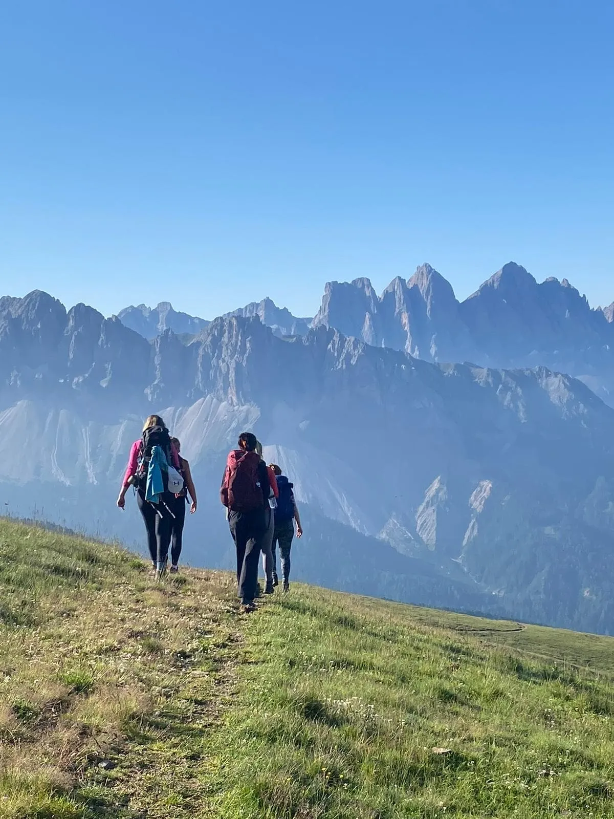
The Alta Via 2 is one of the 6 famous Alta Via treks in the Italian Dolomites. If you are looking for your next challenge, the Alta Via 2 is the perfect match. This trek is full of adrenaline and only suitable for experienced trekkers with surefootedness, experience in the mountains, and a head for heights. The Alta Via 2 includes sharp ridges, Via Ferratas, and steep slopes. Are you brave enough to face it?

The entire Alta Via 2 can be completed in 11 to 14 days. However, not everyone has that much time to spend in the mountains. Therefore, we have created a short route for those who have little time, but still want to enjoy an Italian adventure. We have created a 4-day itinerary in which you will complete the first stages of this tour, from Brixen / Bressanone to Passo Gardena.

Please note: Due to logistical reasons at one of the mountain huts, confirmation of this package may take several weeks. Bookings are most likely confirmed from the month of April on.

Itinerary

Day
1

Bressanone - Rifugio Plose

Duration: 01:15 h
Distance: 2.23 km
Ascent: 380 m
The starting point of the Alta Via 2 is at the station of the cable car in S. Andrea. It goes up to Valcroce and from here, path n° 7 starts towards the Rifugio Plose. A variant for the more trained hikers is to walk up to the Rifugio Plose, starting directly from S. Andrea instead of taking the cable car. The path is quite steep but well maintained and while walking you can enjoy the Dolomites and the flora and fauna of the Puez-Odle nature park. The Plose hut is the first stop on the Alta Via 2 and it is located 2447 m above the city of Bressanone.

Rifugio Plose

Info
Rifugio Plose
Day
2

Rifugio Plose - Rifugio Genova (Schlüterhütte)

Duration: 04:55 h
Distance: 13.3 km
Ascent: 540 m
Descent: 660 m
From Rifugio Plose, following path n° 4 and the signs of the Alta Via 2, you walk downhill for about 2 hours to the Rodella pass. From here, after about 30 minutes, you will find yourself in front of the fork of Sass Putia - the most challenging part of this stage of Alta Via 2. The Forcella della Pùtia appears in the background as an immense gateway to the enchanted kingdom of the Dolomites. To reach it you have to overcome an uphill difference in altitude of 500 meters. At first, the path is gentle, but it then follows some steep switchbacks (often with snow, even at the beginning of July) that climb up to the Forcella della Pùtia (Peitlerscharte), at 2357 meters. From the fork, follow path no. 4 southwest, flat and panoramic, to the Poma Pass (Kreuzkofeljoch, 2340 m), from which you can already see the Rifugio Genova, at 2297 m, to the southwest (30 minutes from Sass de Putia).

Rifugio Genova

Info
Rifugio Genova
Day
3

Rifugio Genova - Rifugio Puez

Duration: 05:35 h
Distance: 12.1 km
Ascent: 810 m
Descent: 650 m

From the Rifugio Genova-Schlüterhütte, at 2297 m, take path n. 3 which, after a stretch to the east, turns to the south along the eastern side of the Bronsoi with a splendid panorama of Odle and Puez. This is an area of great geological and floristic interest. At the altitude of 2421 m, the path turns to the southwest, passes above Munt de Medalges in the Natural Park Pùez-Odle, and reaches the Fùrcia de Medalges (Kreuzjoch), at 2293 meters. Path no. 3 then runs east of the Campillerturm and Sass da l'Ega (Sasso dell'Acqua-Wasserkofele) and then crosses the long Longiarù ridge. Go over the ridge, cross it up to a junction at an altitude of 2389 meters.

Then climb up to reach the Fùrcia dla Róa (Forcella della Rova-Roascharte), at 2617 meters. This saddle divides the Odle Group in the west from the Pùez Group in the east. Attention: at the beginning of the season it is possible to find hard snow in the gully and an ice axe or at least half crampons would be useful. Continuing along the route you descend southwards to a junction at an altitude of about 2500 m in a large debris basin. Here you leave path n. 3, which descends to the right (south-west) and join path n. 2. Path n. 2 will take you east to Fórces de Siëles, at 2505 meters.

After crossing the fork, you will find yourself in front of thin pastures. The Sassonghér appears in the distance, to the east. Now, path no. 2 turns to the north-east and becomes a thin path carved into the rock. The trail is not difficult and there are some metal ropes to help you. Then, after a flat stretch, the path descends eastwards through the wide grassy plain of Munt de Pùez, makes a wide Z, and heads eastwards once more up to the nearby Pùez Hut, at 2475 meters.

Rifugio Puez

Info
Rifugio Puez
See entire itinerary

Included

  • Booking the huts

    We will take care of arranging accommodation on the Alta Via 2 for you. We will also provide you with a detailed itinerary for every stage and instructions on how to get to the trailhead.

  • Full travel guide

    We will send you on your way with a digital travel guide that includes a route description for the Alta Via 2, interactive hiking maps, and the most important information applicable to your trek

  • Accommodation

    During your Alta Via 2, you will spend your nights in mountain huts. In the mountain huts we normally only book dormitories, but we can look into private rooms on request. If the private rooms are fully booked or not available in the hut, we automatically book a bed in dormitories for you. Please note that private rooms are more expensive and there will be an additional charge for this.

  • Half-board

    Accommodation at the huts includes dinner and breakfast. We will arrange this for you as well. This allows you to travel lighter and have one less thing to worry about. Bear in mind that lunch is not included, but it can be purchased at the huts. Here you can also buy an array of snacks and bottled water.

Excluded

  • Traveling to and from

    You have to make your own way to the starting point. The total amount does not include personal transport.

  • Transfers

    Should you need any form of (public) transport on location, this is not part of the trekking package. This includes the use of taxi, bus, cable cars, gondolas etc.

  • Lunch

    Half-board is included in the price of this trek. Lunch, however, is not. You can get something to eat at the mountain huts along the way.

  • Travel Insurance

    Your international travel insurance is your own responsibility. Discuss your itinerary with the insurance company before your trek.

  • Personal expenses

    Personal expenses on such as souvenirs, drinks, and other similar expenses are for your own account.

FAQ

  • Where Is the Alta Via 2?

  • What Is the Best Season for the Alta Via N. 2 Delle Dolomiti?

  • How Do I Get To the Trailhead of the Alta via 2 in the Dolomites?

  • What Is the Difference Between the Alta Via 1 and the Alta Via 2?

  • What Is a Via Ferrata?

How to Book

  • Booking

  • Availability

  • Cancellation policy

Reviews

Book Now
Free cancellation up to two weeks in advance!
Starting at
per person
persons
Book Now
Contact our Trekking Expert
Charisa Kailey-Lê
Charisa Kailey-Lê

Reviews

Just for You