Hiking in Saxon Switzerland: rocks, stairways and multi-day tours

Hiking in Saxon Switzerland: rocks, stairways and multi-day tours
Trekking experts per destination
Free cancellation up to eight weeks in advance
Quick personal advice

Saxon Switzerland is not just the Bastei — and whether your walk turns out good or middling depends on whether you get beyond the Bastei bridge. The region has many faces: Bastei and Rathen as the famous backdrop with the Swedish Holes and Lake Amsel, the Schrammsteine and Affensteine as stairway territory with iron ladders and ridge paths, the Kirnitzschtal as a green valley with a waterfall and a historic tramway, the table mountains on the left bank of the Elbe — Lilienstein, Pfaffenstein, Papststein and Gohrisch — and the Back of Saxon Switzerland around Hinterhermsdorf, where things go quiet. What makes this region the most exciting low-mountain multi-day destination in Germany: rock formations like nowhere else, a national park, suburban trains and ferries instead of a car, and a short journey from Dresden, Leipzig and Berlin. At Bookatrekking you book your Saxon Switzerland walking holiday complete: hotels and guesthouses secured in advance, luggage transfer between the stage towns, offline navigation, a GPX track and up-to-date weather per stage in our app. This guide covers all the sub-regions, our multi-day tours, the finest day loops and stairways, difficulty, the best time to travel, accommodation and a decision guide — so you know which tour suits you.


What makes hiking in Saxon Switzerland special

Walking the Elbe Sandstone Mountains means sandstone instead of granite, table mountains instead of peaks, gorges instead of alpine meadows. Over millions of years, a former seabed eroded into rock needles, reefs, ravines and rock gateways, through which marked paths now lead. This combination is what makes hiking in Saxon Switzerland unique: pines grow on free-standing rock towers, fern-filled gorges lie just a few metres of altitude below, the Elbe runs through the valley as its central axis, and Königstein Fortress sits enthroned on a table mountain like an exclamation mark.

What makes the region so practical as a hiking destination: the Saxon Switzerland National Park is densely marked with trails, the suburban train links Dresden with all the major stage towns in the Elbe valley, ferries cross the river between the banks, and the Kirnitzschtal tramway hauls walkers into the side valley. Walks in Saxon Switzerland rarely end where they begin — the network of trains and ferries makes point-to-point day routes just as easy as multi-day tours.

Compared with the Harz or the Thuringian Forest, Saxon Switzerland stands out for its greater amount of rock, more steps, and more experience per kilometre: shorter in distance, more intense underfoot. A Saxon Switzerland walking holiday is therefore appealing to people who don't want a flat woodland stroll, but aren't after a high-alpine expedition either.


Bastei, Schrammsteine, Kirnitzschtal or Hinterhermsdorf: which side do you start from?

The question isn't where Saxon Switzerland is — it's which town leads into which sub-region. That decides your hiking day more than anything else.

Pirna is the gateway to the region, with a railway station, an old town and direct access to both banks of the Elbe. Our multi-day tours start from here. Rathen is car-free and reachable only by ferry — the classic starting point for the Bastei, the Swedish Holes and Lake Amsel. Königstein opens up the table mountains on the left bank and the fortress. Bad Schandau is the hub for the Schrammsteine, the Kirnitzschtal and the National Park Centre. Schmilka, the last village before the Czech border, is the starting point for the Großer Winterberg and the crossing into Bohemian Switzerland. Sebnitz and Hinterhermsdorf give access to the Back of Saxon Switzerland, with the Kirnitzsch Gorge and the Obere Schleuse.

The suburban train from Dresden serves the whole Elbe valley. Ferries connect the left and right banks, and the Kirnitzschtal tramway plus hiking buses take you into the side valleys. The region works better without a car than with one — on our multi-day tours, the rail connections between stage towns take care of the logistics.


Hiking in Saxon Switzerland: the finest sub-regions compared

Bastei and Rathen: the rock stage, Swedish Holes and Lake Amsel

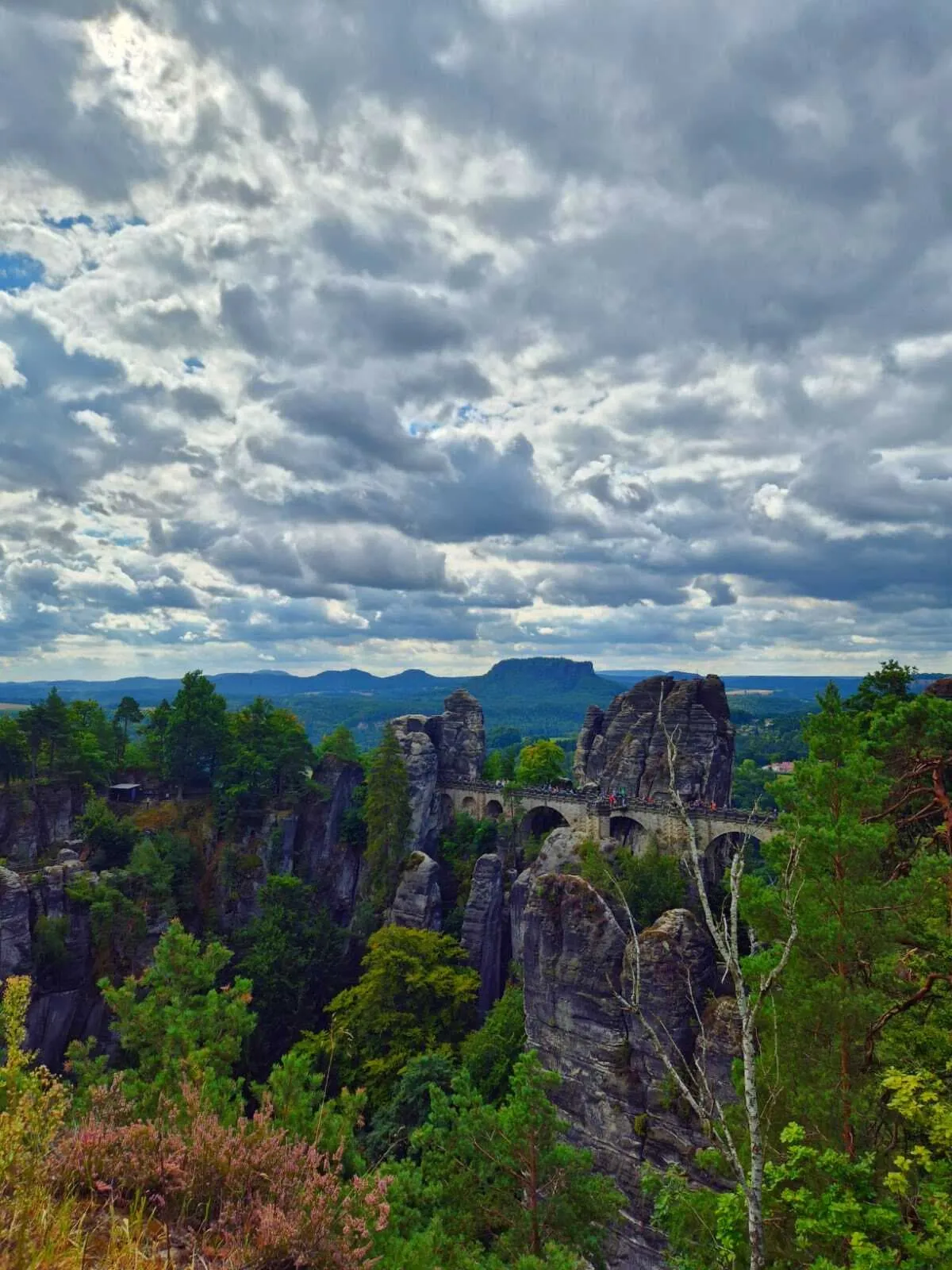
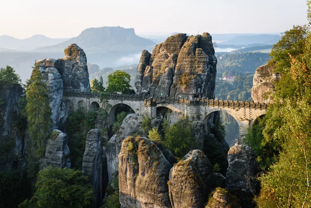
Walking the Bastei means rock needles rising out of the Elbe valley, linked by a 76.5-metre sandstone bridge — with the Swedish Holes, the steepest gorge in the region, directly below. The loop from Rathen leads down through the Swedish Holes with hundreds of steps cut into the rock, past Lake Amsel, and up to the Bastei Bridge. Hiking in Saxon Switzerland's Bastei is the most-visited experience in the region — but if you include the Felsenbühne Rathen open-air stage and the Pavillon viewpoint, you'll find quiet moments even on busy days. If you want to experience the Bastei without the crowds: go early in the morning or on weekdays. The Bastei Bridge is accessible year-round and free of charge.

Schrammsteine and Affensteine: stairways and ridge paths

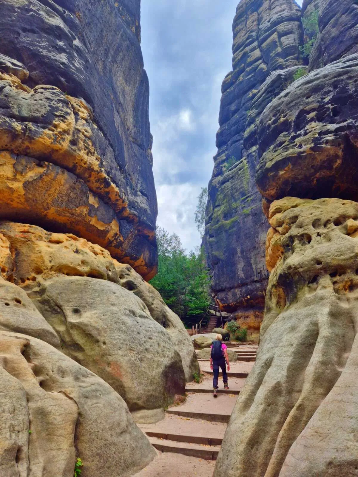
The stairway territory of Saxon Switzerland lies east of Bad Schandau: the Schrammsteine form a long rocky ridge, experienced via the Schrammsteinaussichtsweg viewpoint path and the ridge trail. The Häntzschelstiege and Rübezahlstiege lead through narrow rock clefts up to the plateau using iron ladders and chains — a head for heights is essential, and in wet or frosty conditions these stairways are dangerous. The Zeughaus in the Großer Zschand and the Kuhstall rock gateway are the targets in the valley floor below. The Schrammsteine and Affensteine make up the most demanding sub-region — anyone looking for flatter paths is better off at the Bastei or in the Kirnitzschtal.

Kirnitzschtal and the Lichtenhain Waterfall

The Kirnitzschtal is the green valley of Saxon Switzerland: a wooded valley through which the historic Kirnitzschtal tramway has run since 1898 — the only tram line in the world to pass through a national park. The Lichtenhain Waterfall at the end of the tram line is the most popular family destination: a short walk, a spectacular result. Climbs up to the Affensteine begin from here. The Kirnitzschtal is the most relaxed corner of Saxon Switzerland on the right bank of the Elbe — no ridges, no ladders, just shaded woodland paths and a stream for company.

Table mountains on the left bank: Lilienstein, Pfaffenstein, Papststein and Gohrisch

On the left bank of the Elbe stand free-standing table mountains, reached via short, steep climbs that open onto broad plateaus. The Lilienstein, opposite Königstein Fortress, is the only table mountain lying entirely on Saxon territory; the Pfaffenstein carries the Barbarine rock needle as its landmark. Papststein and Gohrisch are quieter than the right-bank highlights, offering the same panorama without the crowds. Königstein Fortress itself sits enthroned on a table mountain, one of the largest hilltop fortresses in Europe. The left-bank area is the calmer counterpart to the Bastei side.

Back of Saxon Switzerland: Hinterhermsdorf, Kirnitzsch Gorge and Obere Schleuse

The quietest corner of the region lies to the north, around Hinterhermsdorf. The Kirnitzsch Gorge leads through narrow rock ravines to the Obere Schleuse, from where boat trips are offered on the Kirnitzsch. The border forests towards the Czech Republic are still little visited here. In fairness: parts of these forests were altered by the 2022 wildfire; the national park is allowing the burnt areas to develop naturally, and some paths remain closed. The Back of Saxon Switzerland is the opposite of the Bastei — anyone seeking solitude and untouched nature is in the right place here.


Multi-day tours in Saxon Switzerland: from a weekend to a full hiking week

The principle behind multi-day tours in Saxon Switzerland: a different town each day, accommodation booked in advance, your suitcase moved on by luggage transfer to the next stage town, while you walk with just a day pack. On stairways and ladders, this isn't a matter of comfort — it's a safety factor.

Bookatrekking offers three versions of the great circular trail through the region, all as self-guided tours with accommodation booked and luggage transfer included:

Four days including the Bastei Bridge: Malerweg with the Bastei Bridge for a weekend — the compact version for anyone who wants to experience the most famous rock formations of Saxon Switzerland without a car and without hassle. The tour runs from Pirna-Liebethal through the romantic Liebethaler Grund to the Bastei and on to Hohnstein. Ideal as a first Saxon Switzerland walking holiday or as an extended weekend with a direct connection to Dresden.

Seven days through the finest stages: The finest stages of the Malerweg — a hiking week that combines the Bastei, the Schrammsteine, the Back of Saxon Switzerland and the Kirnitzschtal. The tour runs from Pirna to the Neumannmühle and covers the most varied sections of the circular trail. Ideal for anyone with a week to spare who wants to get to know the region in its full breadth.

Ten days, the complete circuit: Walk the complete Malerweg — for those who want to experience both banks of the Elbe in one go, this is the full circuit from Pirna via the Bastei, Schrammsteine, Schmilka and the left-bank table mountains, back to Pirna. The tour covers every sub-region in this guide and takes you deepest into the region.

All three tours follow the same circular trail; the shorter versions are deliberately chosen sections of it. If you'd rather walk from hut to hut in the Bavarian Alps, we also have a guide to hut-to-hut tours in Germany. You'll find our entire German hiking programme on our Your walking holiday in Germany page.


The Malerweg in brief

The Malerweg is the great circular trail of Saxon Switzerland. It runs from Pirna along the right bank via the Bastei, Schrammsteine and the Back of Saxon Switzerland to Schmilka on the Czech border, then returns along the left bank via the table mountains to Pirna. In doing so it links all five sub-regions covered in this guide and is regarded as one of the finest long-distance trails in Germany. Its name goes back to the painters of the German Romantic era, who travelled to Saxon Switzerland in the 19th century in search of inspiration.

Most walkers cover a section of four to seven days — which is exactly what our three tours are built around. If you're after the complete stage-by-stage description with starting points, stage character and difficulty, you'll find it in our detailed Malerweg route blog.


Day tours, loops and stairways in Saxon Switzerland

What most walkers are really looking for: a loop with a clear highlight, starting from your base, reachable by suburban train or bus. That's why "hiking in Saxon Switzerland loop" and "Bastei walking loop" are such commonly searched terms. The region offers exactly that, across various levels of difficulty:

The Bastei loop from Rathen, via the Swedish Holes and Lake Amsel, is the region's best-known day tour. Walking the Bastei's Swedish Holes means: steep rock ravines heading down, an idyllic reservoir lake, and a climb up to the Bastei Bridge. The loop is suitable as a family walk, but requires sturdy footwear and sure-footed children.

The Schrammstein viewpoint from Bad Schandau leads onto the reef with a panoramic view over the entire right-bank area; the ridge path that follows is, for experienced walkers, one of the finest lines in the Elbe Sandstone Mountains.

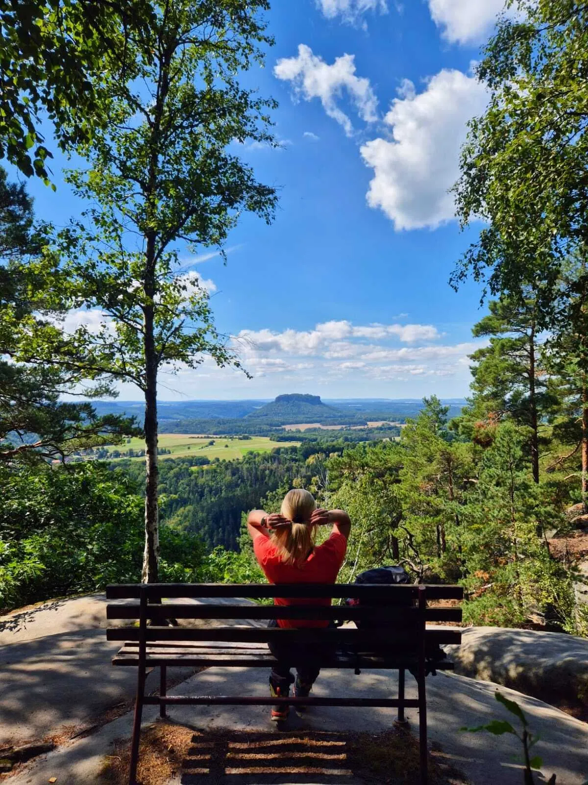
The Lilienstein from Königstein is the classic table mountain loop on the left bank: a short climb, a broad plateau, views of the fortress and the Elbe valley — perfectly suited to beginners.

The Pfaffenstein with the Barbarine is a short, striking loop to one of the region's most distinctive rock needles. The Kuhstall in the Großer Zschand is a natural rock gateway that families use as their destination. The Kirnitzsch Gorge with the Obere Schleuse near Hinterhermsdorf rounds things off with a boat trip — peaceful, far from the Bastei crowds.

Stairways: the Häntzschelstiege, Rübezahlstiege and Heilige Stiege are secured paths through narrow rock clefts and over iron ladders. A head for heights is required, but no via ferrata kit is needed. In wet or frosty conditions the stairways are dangerous and should be avoided. Stairways are not suitable for dogs or young children.

Hiking in Saxon Switzerland with children works best on short loops with a clear destination: the Swedish Holes, the Kuhstall, the Lichtenhain Waterfall, a boat trip at the Obere Schleuse and the Felsenbühne Rathen open-air stage all offer children variety and excitement without overwhelming distances.

Walking in Saxon Switzerland with a dog: dogs must be kept on a lead within the Saxon Switzerland National Park — this is not a recommendation, it's a rule. Many paths work well with a dog, but stairways with iron ladders do not. If you're booking with a dog, let us know when you book: we'll then select suitable dog-friendly accommodation.

Sights to see while hiking in Saxon Switzerland: the region's biggest attractions double as hiking destinations — Königstein Fortress, the Bastei Bridge, the Kuhstall and the Barbarine on the Pfaffenstein. Each can be built into a day tour without needing to plan a separate excursion.


How hard is hiking in Saxon Switzerland — and who is it suited to?

Saxon Switzerland is low-mountain terrain — with one special feature. The daily stages are short; the difficulty lies not in distance but in steps, ladders, narrow rock clefts and the constant up and down between valley and reef. It adds up: anyone starting the day well-rested and with good footwear will get through most day loops just fine. Anyone who underestimates how slippery the sandstone becomes after rain can run into trouble.

The trouble spots: wet sandstone becomes smooth and slippery. Stairways are not safe to walk in rain or frost. Some viewpoint rocks are unsecured. Closures due to fallen wood and wildfire-damaged areas are possible and must be observed — it's worth checking the national park's trail service before setting out.

Who Saxon Switzerland suits:

  • Beginners are well catered for on the table mountain loops and the paths through the Kirnitzschtal. The Bastei loop, the Lilienstein and the Lichtenhain Waterfall require no prior experience, just sturdy shoes.
  • Families will find a rewarding programme on the short loops with a clear goal — the Swedish Holes, the Kuhstall and the boat trip at the Obere Schleuse are highlights for children.
  • Experienced walkers take on the stairways and ridge paths and experience the region at its most intense.
  • Alpine hikers use Saxon Switzerland as an off-season destination: shorter days, different terrain, a different character altogether.

Our three tours ranked by difficulty: the four-day package is the most accessible — the stages run through woodland and to the Bastei, with no stairways. The seven-day version includes the Schrammsteine and suits anyone with a bit of hiking experience already. The ten-day circuit covers the full range of terrain in the region, including its most demanding sections.


The best time to go hiking in Saxon Switzerland

The Elbe Sandstone Mountains can be walked year-round — but the seasons make a noticeable difference.

April and May bring fresh green in the ravines, views still uncluttered by dense foliage, and long days. Outside public holidays, things are quiet and accommodation is easier to find. Ideal for peaceful walks in Saxon Switzerland without queuing at the Bastei.

June to August is the busiest time. The Bastei on summer weekends gets very crowded: starting early or heading instead to the Back of Saxon Switzerland helps. During hot, dry spells in summer there is a risk of wildfire — the 2022 fire permanently altered parts of the Back of Saxon Switzerland and continues to affect some paths.

September and October are, for most people, the best time to go. Settled autumn weather, glowing colours on the reefs, mist in the ravines in the early morning. Before temperatures drop and the days shorten, this period offers the most complete hiking experience.

November to March: short daylight hours, ice on steps and stairways, reduced ferry and Kirnitzschtal tramway services, and many guesthouses closed on rest days. Table mountains remain walkable in winter, but stairways should be avoided. If you want the Bastei to yourself in the snow, winter delivers — with the right preparation.

Our multi-day tours run most comfortably during the summer half of the year. The Bookatrekking app shows you the current weather for each stage town, right down to the location of your accommodation — not a general forecast, but the report for the exact place where you're staying.


Accommodation and luggage transfer in Saxon Switzerland

Saxon Switzerland has no hut system. You stay each night in the next town down in the valley — in hotels, guesthouses and inns in Rathen, Bad Schandau, Königstein, Schmilka and the smaller villages along the way. Holiday flats are also common, but are logistically demanding for multi-day tours.

Why planning ahead matters: car-free towns like Rathen can only be reached by ferry — searching for a room at short notice in the evening won't get you far. On summer weekends, popular stage towns book up quickly. Our tours book the accommodation for every stage in advance — you don't need to worry about a thing along the way.

Luggage transfer in Saxon Switzerland isn't a luxury but a practical difference: on iron ladders and in narrow rock clefts, a heavy rucksack on your back is no pleasure — it's a risk factor. With just a day pack, you walk lighter, safer and tire more slowly.

The Bookatrekking package includes: bed-and-breakfast accommodation in every stage town, luggage transfer from one place to the next, route descriptions, and the Bookatrekking app with offline maps, a GPX track and the current weather for each stage town.

If you'd rather choose a single base and take day tours from there: Bad Schandau and Rathen work particularly well, since both give direct access to several sub-regions. And for anyone who fancies swapping sandstone for alpine meadows, mountain huts and high-alpine panoramas afterwards, we recommend our guide to hut-to-hut tours in the Bavarian Alps.


Which tour suits you? Hiking in Saxon Switzerland by time budget

Tour Days Who it's for Character Book
Weekend with the Bastei Bridge 4 days first multi-day tour, short break the famous rocks in compact form View tour
The finest stages 7 days a hiking week with variety Schrammsteine, table mountains, Kirnitzschtal View tour
The complete circuit 10 days for those who want to walk both banks of the Elbe in full the entire circuit, going deepest into the region View tour

You'll find current prices, available dates and full details of what's included on the relevant trip page.

A quick guide to choosing: if you're short on time or visiting Saxon Switzerland for the first time, four days is enough for the Bastei and its immediate surroundings. If you have a week to spare and want to really get to know the region, seven days is the right choice. If you want to walk both banks of the Elbe in full and dive deep into the quieter sub-regions, take ten days. For day tours from a single base, a base in Bad Schandau or Rathen is all you need.

On navigation: the trail markings within the Saxon Switzerland National Park are reliable. In narrow rock clefts and at junctions, the GPX track in the Bookatrekking app helps, and it's available offline too. You'll find our full range of German walking holidays on our walking holiday overview for Germany.


Frequently asked questions about hiking in Saxon Switzerland

  • How long does it take to walk from the car park to the Bastei Bridge?

    From the car parks up on the Bastei plateau, it's a short, almost level walk to the bridge. From Rathen down by the river, a steep climb up many steps leads to the top. If you're doing the Swedish Holes loop, plan for the whole tour to take half a day to a full day of walking.

  • Which are the best hiking routes in Saxon Switzerland?

    The Schrammstein viewpoint, the Bastei loop via the Swedish Holes, the Lilienstein and the Kirnitzsch Gorge are among the finest walks in Saxon Switzerland. A multi-day tour combines all of these highlights — our seven-day tour through the finest stages covers this in full.

  • What are the best walking trails in the Elbe Sandstone Mountains?

    The ridge path of the Schrammsteine is, for experienced walkers, one of the finest lines in the Elbe Sandstone Mountains. The Häntzschelstiege offers the most intense rock experience. Table mountain loops such as the Lilienstein and Pfaffenstein are more accessible. The full circular trail is described stage by stage in the Malerweg route blog.

  • What insider tips are there for walks in Saxon Switzerland?

    The Back of Saxon Switzerland around Hinterhermsdorf is the least-visited sub-region, with a boat trip on the Kirnitzsch and quiet border forests. Papststein and Gohrisch offer the same panorama as the Bastei, but without the crowds. And: the Bastei early in the morning is almost yours alone.

  • Which hiking trails in Saxon Switzerland are suitable for beginners?

    The Bastei loop from Rathen, the climb up the Lilienstein, the walk to the Lichtenhain Waterfall in the Kirnitzschtal and the boat trip at the Obere Schleuse are the best introductory walks. They require no prior experience, no head for heights and no ladders — just sturdy shoes.

  • Which walk at the Bastei is the finest?

    In our view, the finest Bastei walk is the loop from Rathen via the Swedish Holes and Lake Amsel up to the Bastei Bridge. It combines the gorge, the peaceful lake and the famous view in one tour, and shows three completely different sides of the Bastei.

  • What's the best way to get to the Bastei?

    The best way is by suburban train to Kurort Rathen, then by ferry across the Elbe and on foot up the climb to the Bastei. If you're arriving by car, park in the car parks above and either walk down or take the shuttle bus. The Bastei itself is car-free.

  • How many days do you need for Saxon Switzerland?

    An extended weekend is enough for the Bastei and its immediate surroundings. To really experience the region — the Schrammsteine, the table mountains, the Kirnitzschtal — four to seven days makes sense. The full circuit of both banks of the Elbe takes ten days. Our four-day tour with the Bastei Bridge is the most compact way in.


    If you'd like to plan the region as a whole, you'll find every German multi-day tour compared on our walking holiday overview page for Germany. The full stage-by-stage description of the circular trail is in the Malerweg route blog. And for anyone who fancies swapping sandstone for alpine meadows, mountain huts and high-alpine panoramas, we also have our guide to hut-to-hut tours in the Bavarian Alps. Beyond the border, Bohemian Switzerland awaits as a seamless continuation of the sandstone landscape — a chapter for another trip.

Packing List for the Malerweg

It doesn't matter where you are trekking or for how long: carrying the right equipment with you is paramount. For a hiking trip in the mountains, a good is backpack essential. Its size will depend on how many days you will be spending in the mountains, the season, and the clothes you will be taking with you. We have prepared a packing list with some essential clothing that you should include and some extras that you may find useful:
  • Essentials

  • Extras

Safe Hiking Tips for the Malerweg

When hiking, it is wise to be aware of a few points. Even if this is not your first time, you should never underestimate the mountains. Good tour planning and compliance with the regulations in the mountains will significantly increase safety. To ensure that your hiking adventure is a safe and enjoyable experience, here below you can find a list of 8 recommendations for safe hiking in the mountains:
  • Know your limits

    Hiking the Malerweg is the perfect outlet to escape from daily life. It is an endurance sport along with a beautiful nature experience with a positive effect on body and mind —as long as one is in good shape and has a realistic picture of one's possibilities and limits—. Never overestimate yourself or underestimate the route. Don't overdo it! Always choose the slower option and take more time for your plans. Hiking under time pressure is not fun and at too fast a pace it can be dangerous. Be wise!

  • Plan carefully

    Good planning is half the work! Hiking maps, literature, the Internet and expert advice are invaluable when planning the route of the Malerweg and enable you to determine the length, altitude difference, difficulty and conditions of the hike. When planning group treks, the itinerary should always be planned for the weakest member of the group! The weather in the mountains can change incredibly quickly and rain, wind and cold all increase the risk factor. For this reason, always check the weather forecast beforehand and contact our trekking experts to find your way before you start.

  • Be fully equipped

    Equipment is everything. In the most extreme case, it makes the difference between life and death, and in any case, it definitely makes the difference between having fun and having a bad time. Food and water, sunscreen and waterproof and warm clothes must always be in your backpack, as well as a first aid kit and a mobile phone with a full battery (in case there is an emergency). However, packing light makes hiking easier, so don't take too much extra luggage with you. Your equipment should always be suitable for the terrain you'll be hiking on in the Malerweg.

  • Wear suitable footwear

    Good walking shoes protect your feet and provide a better fit. Shoes with a good fit, with non-slip soles, water-resistant and lightweight are a must for additional walking pleasure during the Malerweg. Trail running shoes are great for a weekend in the mountains, but on longer hikes or more technical trails, you'll want at least A/B hiking boots. That means it is recommended wearing high mountain shoes that are water-repellent with extra ankle support to prevent sprains.

  • Stay on marked trails

    Malerweg has endless marked hiking trails, which are controlled and maintained and should not be deviated from. It may be tempting, but it's not a good idea to take shortcuts or alternative routes through unmarked terrain. It increases the risk of disorientation and you're more likely to get lost and have accidents or fall in the mountains. Even steep slopes of packed old snow are often underestimated and dangerous. Are you in doubt? Better don't do it. For easy navigation we work with our trusted partner Komoot, whose interactive maps, also available offline, provide you with the necessary digital means to get from A to B. As a backup, make sure to bring a hiking guide or a paper map with you. FYI, 75% of stumbles occur due to carelessness on marked paths or roads, not in open terrain!

  • Take regular breaks

    Remember you're on a hiking trip. Timely and regular breaks not only provide welcome relaxation but also make it possible to enjoy the Malerweg. The body needs a regular food and drink intake to maintain performance and concentration. Our advice is that if you have little time, it's better to follow the short itinerary than to speed up the long one.

  • Stay reachable

    If you are hiking solo or in small groups it is advisable to inform people back home about your plans, what route you are taking and when you plan to return. Even small incidents can lead to unpleasant emergencies so make sure you are available at all times. Bring a charged phone containing at least the phone numbers of immediate family members, your accommodations en route and the emergency phone numbers operating on the Malerweg.

  • Respect nature

    Leave no rubbish behind, prevent noise, stay on the marked trails, do not disturb wildlife or grazing animals, and respect protected areas.

Where Can I Book the Malerweg?

At Bookatrekking.com you can book the self-guided Malerweg and many other treks. We take care of all the details for you, including arranging accommodations and providing you with relevant information well in advance of your trek. Find our offers here. Our easy-to-use platform allows you to browse and compare different trekking options and to find the perfect fit for your interests, abilities, and budget.

If you have any questions about a specific trek or need help choosing the right one for you, our team of trekking experts is here to assist you. Simply reach out to us and we will be happy to provide you with personalized recommendations and advice to help you plan the trekking adventure of a lifetime.

About Us

At Bookatrekking.com, you will find the trek that will make your life unforgettable. Whether you want to explore the Inca Trail or climb Kilimanjaro. Bookatrekking.com has a wide and varied range of first-class treks. No false promises are made here. Transparent prices and bookings are fixed instantly. Find, compare, book and trek!
Read more about us
About Us
About Us