Hiking in the Cotswolds: Best Walks, Villages and When to Go

Hiking in the Cotswolds: Best Walks, Villages and When to Go
Trekking experts per destination
Free cancellation up to eight weeks in advance
Quick personal advice

Hiking in the Cotswolds means rolling limestone hills, honey-stone villages and a steep western escarpment with wide views over the Severn Vale. The region covers 787 square miles (2,038 km²), holds more than 3,000 miles of public footpaths, and reaches its highest point at Cleeve Hill at 330 m. This guide lists 11 Cotswolds walks with distance, time and grade, covers the best villages to explore on foot, and explains when to go and how hard it is. If you want to walk several days in a row, have a look at our Cotswold Way walking holiday from Painswick to Bath.

Hiking in the Cotswolds: what makes it special

Protected since 1966 as an Area of Outstanding Natural Beauty and now officially called the Cotswolds National Landscape, this is the largest such designation in England. Over 3,000 miles of public footpaths cross it, including two National Trails: the Cotswold Way and the start of the Thames Path near Kemble.

The landscape splits into two distinct characters. To the east, open wolds and gentle river valleys hold the classic stone villages that most people picture. To the west, the land drops sharply off a limestone escarpment into the Severn Vale, and that is where the best long views are. Almost every walk on this list follows some part of that edge.

For a broader picture of routes across the country, see our guide to hiking in England.

Where are the Cotswolds and how do you get there?

The Cotswolds run roughly from Chipping Campden in the north to Bath in the south, mostly within Gloucestershire but also covering parts of Oxfordshire, Worcestershire and Wiltshire.

By train from London Paddington (GWR): Moreton-in-Marsh in about 1 hour 30 minutes, Kemble in about 1 hour 10 minutes, Stroud in about 1 hour 30 minutes, and Bath Spa at the southern end. Kingham, Charlbury and Moreton-in-Marsh all sit on the Cotswold Line, which means you can step off the train and start walking from the station without needing a car.

Local bus services connect several of the trailheads listed in this guide. Each walk below includes a Getting there note where bus access exists, but frequencies are low, so check current timetables before you travel. For the most remote start points, a car or taxi is the most practical option.

The best walks in the Cotswolds

The eleven walks below cover the full range of Cotswolds hikes, from a 3-mile stroll of about an hour to escarpment walks of 6 miles and more. The table gives you an at-a-glance comparison; the sections below add the detail.

Walk Area Distance Time Grade
Chipping Campden and Dover's Hill North 4.5 miles (7.2 km) 2.5-3.5 hrs Moderate
Broadway Tower walk North 4 miles (6.4 km) 2.5-3 hrs Moderate
Stanton, Snowshill and the Edge North 6 miles (9.7 km) 3.5-4.5 hrs Moderate
Winchcombe and Belas Knap North-central 5.25 miles (8.4 km) 3-4 hrs Moderate
Bourton-on-the-Water walks East 5.4 miles (8.7 km) 2.5 hrs Easy
Bibury and Coln St Aldwyns East 6 miles (10 km) 3 hrs Easy, no stiles
Cleeve Hill walk Central 6 miles (9.7 km) 3.5-4.5 hrs Moderate
Haresfield Beacon West 6 miles (9.7 km) 2.5-3.5 hrs Moderate
Painswick Stream West 3 miles (4.8 km) 1-1.5 hrs Steep slopes
Cam Long Down and Uley Bury West 4 miles (6.4 km) 2.5-3.5 hrs Moderate-difficult
Wotton-under-Edge and the Tyndale Monument South 4.9 miles (7.9 km) 4 hrs Moderate

Chipping Campden and Dover's Hill

Distance: 4.5 miles (7.2 km), short cut 3 miles · Time: 2.5-3.5 hours · Grade: Moderate with steep sections (short cut easy) · Start: Chipping Campden (free car park in Back Ends) · Getting there: Bus from Stratford-upon-Avon and Broadway.

Chipping Campden walks begin at the 1627 Market Hall, where the Cotswold Way also starts. The route climbs to Dover's Hill, with a broad view over the Vale of Evesham; Dover's Hill is the site of the Cotswold Olimpick Games, first held in 1612. In May, Lynches Wood on this route is full of bluebells.

Broadway Tower walk

Distance: 4 miles (6.4 km) · Time: 2.5-3 hours · Grade: Moderate with some steep sections, no stiles · Start: Broadway (three car parks) · Getting there: Bus from Cheltenham, Chipping Campden, Evesham and Stratford-upon-Avon.

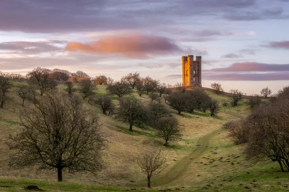
The Broadway Tower walk climbs from Broadway village to Broadway Tower, a folly built between 1798 and 1799 on Broadway Hill at about 312 m, the second-highest point in the Cotswolds. Part of the route follows the Cotswold Way along the escarpment.

Stanton, Snowshill and the Edge

Distance: 6 miles (9.7 km), short cut 2.5 miles · Time: 3.5-4.5 hours · Grade: Moderate, steep sections and stiles, muddy after rain · Start: Stanton (village club by the cricket ground; do not park in the village centre) · Getting there: Bus 606 Cheltenham-Broadway plus a short walk.

The route climbs from Stanton to Shenberrow Hill Camp, an Iron Age hill fort, then heads across to Snowshill; Snowshill Manor (National Trust) is close to the route. Part of the walk follows the Cotswold Way along the edge.

Winchcombe and Belas Knap

Distance: 5.25 miles (8.4 km), short cut 3.5 miles · Time: 3-4 hours · Grade: Moderate, steep sections and stiles · Start: Winchcombe (Back Lane car park) · Getting there: Bus from Cheltenham and Chipping Campden.

From the former Saxon capital of Winchcombe the path climbs above Sudeley Castle to Belas Knap, a Neolithic long barrow. The climb gives wide views back over Winchcombe.

The best walks in the Cotswolds

Village walks: Bourton-on-the-Water, the Slaughters, Stow and Bibury

The classic village walks in the Cotswolds lie in the eastern valleys, where small rivers connect stone villages. They are popular, especially on summer weekends, so an early start pays off. For quieter paths, the escarpment walks further south, around Haresfield, Uley and Wotton-under-Edge, usually see fewer visitors than the villages in the east.

Stow-on-the-Wold is a hilltop market town, and footpaths lead down from it to the surrounding villages. Walks from Stow-on-the-Wold have no single fixed circuit: choose a direction and return another way.

Bourton-on-the-Water walks

Distance: 5.4 miles (8.7 km) short loop · Time: About 2.5 hours · Grade: Easy · Start: Bourton-on-the-Water village · Getting there: Check locally.

The short Bourton-on-the-Water loop visits Lower Slaughter and Upper Slaughter, two villages about a mile apart connected by a path along the River Eye. The Warden's Way, a waymarked route, extends the walk north to Winchcombe. A longer Cotswolds National Landscape circular of 10.2 miles adds about 250 m of ascent and takes 4-5 hours.

Bibury and Coln St Aldwyns

Distance: About 6 miles (10 km) · Time: About 3 hours · Grade: Unsurfaced paths, about 150 m of ascent and descent, no stiles · Start: Coln St Aldwyns · Getting there: Check locally.

This Bibury walk is one of the designated "Miles without Stiles" routes in the Cotswolds, making it accessible to a wider range of walkers. The path passes Arlington Row, a row of stone cottages cared for by the National Trust beside the Rack Isle water meadow, and follows the River Coln.

Village walks: Bourton-on-the-Water, the Slaughters, Stow and Bibury

Circular walks along the Cotswold escarpment

The steepest hills and widest views in the Cotswolds are on the western escarpment. The Cotswold Way runs along this edge for much of its length, and several of the circular walks below use sections of it before looping back through woodland or valley. These are the Cotswolds hikes that reward the most on a clear day, and all five are Cotswolds circular walks rather than out-and-back routes.

Cleeve Hill walk

Distance: 6 miles (9.7 km), shorter route 4 miles · Time: 3.5-4.5 hours (shorter route 2-3 hours) · Grade: Moderate, no stiles, some steep sections (shorter route easy and mostly level) · Start: Old quarry car park off the golf club lane · Getting there: Bus from Cheltenham and Winchcombe (golf course junction).

Cleeve Hill is the highest point in the Cotswolds at 330 m. The open common is exposed in wind and fog, so the Cleeve Hill walk needs more weather awareness than most routes here; on a clear day the views reach far across the Severn Vale.

Haresfield Beacon

Distance: 6 miles (9.7 km) · Time: 2.5-3.5 hours · Grade: Moderate slopes, no stiles · Start: Shortwood National Trust car park (charges apply) · Getting there: Bus 63 Stroud-Gloucester.

Haresfield Beacon is one of the sharpest viewpoints on the escarpment, looking west over the Severn Vale. The walk passes through Standish Wood (National Trust) and along the edge of the escarpment.

Painswick Stream

Distance: 3 miles (4.8 km) · Time: 1-1.5 hours · Grade: Uneven paths with steep slopes, good fitness needed · Start: Painswick · Getting there: Check locally.

The Painswick Stream walk follows the valley past the sites of five historic mills. Painswick is also the starting point of our self-guided Cotswold Way trips.

Cam Long Down and Uley Bury

Distance: 4 miles (6.4 km), shorter 1.5 miles · Time: 2.5-3.5 hours · Grade: Moderate to difficult, stiles, steps and steep sections · Start: Uley · Getting there: Bus 65 from Stroud.

Uley Bury is an Iron Age hill fort, and the circuit combines it with Cam Long Down and Downham Hill. Bluebells appear on Cam Peak in early May.

Wotton-under-Edge and the Tyndale Monument

Distance: 4.9 miles (7.9 km) · Time: About 4 hours · Grade: Moderate · Start: Wotton-under-Edge (three free car parks) · Getting there: Bus from Stroud and Gloucester via Dursley, and from Bristol and Yate.

The Tyndale Monument stands above North Nibley and honours William Tyndale, who translated the Bible into English and is thought to have been born nearby. 120 steps lead to the top. The route also passes Brackenbury Ditches hill fort and loops through Westridge Woods.


Circular walks along the Cotswold escarpment

The Cotswold Way: the long-distance walk in brief

The Cotswold Way is a National Trail running 102 miles (164 km) from Chipping Campden to Bath along the escarpment edge, marked throughout by acorn waymarks. The National Trail suggests about 10 days to walk the full route. Many of the day walks above use sections of it: the Broadway Tower walk, the Chipping Campden circuit, the Winchcombe and Belas Knap route, and several escarpment walks all join the trail at some point. For maps, stages and full planning detail, see our complete Cotswold Way guide.

Walking the southern Cotswolds from Painswick to Bath

Our two self-guided trips walk the southern section of the Cotswold Way from Painswick to Bath, inn to inn, with accommodation booked and luggage transferred to your next stop each day. Neither trip covers the full National Trail; both walk the southern half, with escarpment woods and the arrival in Bath.

The Cotswold Way Relaxed (9 days) offers 7 walking days over 98.3 km, averaging about 14 km a day. It is graded Intermediate and suits walkers with some multi-day experience who want comfortable daily distances.

The Cotswold Way Intensive (6 days) covers 95.5 km in 4 walking days, averaging about 24 km a day with the longest day at 31.5 km. It is graded Advanced and suits fit walkers who are comfortable with long back-to-back days.

Highlights on both routes include Haresfield Beacon, Stinchcombe Hill, the Tyndale Monument and the view of Bath from Prospect Stile. The northern section from Chipping Campden to Painswick is not part of either trip.

Walking the southern Cotswolds from Painswick to Bath

How hard is hiking in the Cotswolds?

Hiking in the Cotswolds is generally easy to moderate. There are no mountains, most paths are waymarked, and the highest point is only 330 m. That said, the western escarpment produces short, sharp climbs, fields in the eastern valleys often have gates and stiles, and paths in woodland or across farmland can be muddy after rain. If stiles are a concern, the Broadway Tower walk, Cleeve Hill, Haresfield Beacon and the Bibury route are all stile-free. With younger children, the shorter options work best: the 3-mile Painswick Stream walk, the easy 3-mile short cut of the Chipping Campden walk and the 4-mile short Cleeve Hill route, which is mostly level.

For a multi-day trip, the key preparation is time on your feet before you go. For the Cotswold Way Relaxed, build up to a few consecutive days of around 14 km. For the Intensive, make sure you are comfortable walking 20 km or more on back-to-back days before you arrive. Good waterproof footwear matters in any season; trail shoes work for summer, but sturdier boots with ankle support are better from autumn through spring.

Best time for walks in the Cotswolds

The Cotswolds can be walked all year, and each season has a case for it.

April and May are particularly good: bluebells appear in Lynches Wood near Chipping Campden and on Cam Peak around early May, and wild garlic fills the valley woodlands. The days are long enough for the longer routes but the summer crowds have not yet arrived.

Early autumn (September and early October) is another strong option. The light is lower and the school-holiday pressure on car parks and paths has eased.

Summer weekends bring the most visitors, especially to Bourton-on-the-Water and Broadway. An early start solves most of the congestion. Winter walking is perfectly feasible but mud is a real factor, daylight is short from November onwards, and hilltop routes like Cleeve Hill can be exposed.

Our self-guided trips run from April to October. On those trips, the Bookatrekking app shows a weather forecast for each night's accommodation based on the coordinates of that specific location, so you can plan layers and rain gear for the next day with confidence.

Which Cotswolds hike suits you?

Option Length Best for Price
Day walk 1.5 to 10 miles A day out by train or car Free
Village-based weekend 2 or 3 day walks First visit, villages Your own accommodation
Cotswold Way Relaxed 9 days, 98.3 km Comfortable daily distances From 1,225 euros per person
Cotswold Way Intensive 6 days, 95.5 km Fit walkers, longer days From 810 euros per person

Prices are per person when two people travel together. Both trips include accommodation, breakfast where possible, daily luggage transfer between stops and access to the Bookatrekking app with route maps, offline GPS navigation, GPX files and the weather forecast per accommodation.

For more multi-day routes across the country, our walking holidays in England page covers the full programme. If you are comparing options, the South Downs Way, Hadrian's Wall Path and South West Coast Path are the other classic long-distance walks in England.

Ready to plan your trip? Our Cotswold Way guide covers the full National Trail in detail, and our walking holidays in England page shows our other trips in England.

Frequently asked questions about hiking in the Cotswolds

  • What are the best walks in the Cotswolds?

    The best walks in the Cotswolds depend on what you are after. For escarpment views, the Broadway Tower walk (4 miles), Cleeve Hill (6 miles) and Haresfield Beacon (6 miles) stand out. For villages, the Bourton-on-the-Water loop via the Slaughters (5.4 miles) and the Bibury route (6 miles) are the classic choices. All 11 Cotswolds walks are listed above with full fact lines.

  • How long is the Broadway Tower circular walk?

    The Broadway Tower circular walk is 4 miles (6.4 km) and takes about 2.5 to 3 hours at a relaxed pace. It is graded moderate with some steep sections and is stile-free throughout. The route starts in Broadway, climbs to the tower at about 312 m on Broadway Hill, and returns to the village.

  • What are the best sections of the Cotswold Way to walk?

    The most rewarding sections for day walks are the Broadway escarpment from Chipping Campden to Stanton, the Cleeve Hill stretch near Winchcombe, and the southern section from Painswick through to Wotton-under-Edge and on to the approach into Bath. For more detail on the full route, see our Cotswold Way guide.

  • What are the top 5 Cotswold villages to visit on foot?

    The five villages most walkers want to reach on foot are Chipping Campden (the northern gateway of the Cotswold Way), Broadway (start of the tower walk), Bourton-on-the-Water (the river walk to the Slaughters), Bibury (Arlington Row and the River Coln) and Painswick (the escarpment town where our self-guided trips start).

  • How difficult is hiking in the Cotswolds?

    Hiking in the Cotswolds is generally easy to moderate. The terrain involves short steep climbs on the escarpment, gates and stiles in the eastern valleys, and mud on field paths after rain. There are no mountains and the highest point is 330 m. Stile-free routes include Broadway Tower, Cleeve Hill, Haresfield Beacon and the Bibury walk.

  • Can you visit the Cotswolds by train without a car?

    Yes. Trains from London Paddington reach Moreton-in-Marsh in about 1 hour 30 minutes, Kingham and Charlbury lie on the same Cotswold Line, and Bath Spa serves the south. Several walks in this guide can be reached by local bus; see Getting there for each walk. Check current timetables, as local services run infrequently.

  • How much does it cost to walk the Cotswold Way?

    Day walks on public footpaths are free. For a self-guided trip, our Cotswold Way Intensive (6 days) starts from 810 euros per person and the Cotswold Way Relaxed (9 days) starts from 1,225 euros per person, both when two people travel together. Those prices include accommodation, breakfast where possible and daily luggage transfer.

  • When is the best time to hike in the Cotswolds?

    April to early October is the main walking season. April and May offer bluebells and wild garlic with smaller crowds; early September gives good weather with much less pressure on popular routes. Summer weekends are the busiest period, especially around Bourton-on-the-Water and Broadway. Winter is feasible but mud, short days and exposed hilltops are real factors to plan for.

Packing List for the Cotswold Way

It doesn't matter where you are trekking or for how long: carrying the right equipment with you is paramount. For a hiking trip in the mountains, a good is backpack essential. Its size will depend on how many days you will be spending in the mountains, the season, and the clothes you will be taking with you. We have prepared a packing list with some essential clothing that you should include and some extras that you may find useful:
  • Essentials

  • Extras

Safe Hiking Tips for the Cotswold Way

When hiking, it is wise to be aware of a few points. Even if this is not your first time, you should never underestimate the mountains. Good tour planning and compliance with the regulations in the mountains will significantly increase safety. To ensure that your hiking adventure is a safe and enjoyable experience, here below you can find a list of 8 recommendations for safe hiking in the mountains:
  • Know your limits

    Hiking the Cotswold Way is the perfect outlet to escape from daily life. It is an endurance sport along with a beautiful nature experience with a positive effect on body and mind —as long as one is in good shape and has a realistic picture of one's possibilities and limits—. Never overestimate yourself or underestimate the route. Don't overdo it! Always choose the slower option and take more time for your plans. Hiking under time pressure is not fun and at too fast a pace it can be dangerous. Be wise!

  • Plan carefully

    Good planning is half the work! Hiking maps, literature, the Internet and expert advice are invaluable when planning the route of the Cotswold Way and enable you to determine the length, altitude difference, difficulty and conditions of the hike. When planning group treks, the itinerary should always be planned for the weakest member of the group! The weather in the mountains can change incredibly quickly and rain, wind and cold all increase the risk factor. For this reason, always check the weather forecast beforehand and contact our trekking experts to find your way before you start.

  • Be fully equipped

    Equipment is everything. In the most extreme case, it makes the difference between life and death, and in any case, it definitely makes the difference between having fun and having a bad time. Food and water, sunscreen and waterproof and warm clothes must always be in your backpack, as well as a first aid kit and a mobile phone with a full battery (in case there is an emergency). However, packing light makes hiking easier, so don't take too much extra luggage with you. Your equipment should always be suitable for the terrain you'll be hiking on in the Cotswold Way.

  • Wear suitable footwear

    Good walking shoes protect your feet and provide a better fit. Shoes with a good fit, with non-slip soles, water-resistant and lightweight are a must for additional walking pleasure during the Cotswold Way. Trail running shoes are great for a weekend in the mountains, but on longer hikes or more technical trails, you'll want at least A/B hiking boots. That means it is recommended wearing high mountain shoes that are water-repellent with extra ankle support to prevent sprains.

  • Stay on marked trails

    Cotswold Way has endless marked hiking trails, which are controlled and maintained and should not be deviated from. It may be tempting, but it's not a good idea to take shortcuts or alternative routes through unmarked terrain. It increases the risk of disorientation and you're more likely to get lost and have accidents or fall in the mountains. Even steep slopes of packed old snow are often underestimated and dangerous. Are you in doubt? Better don't do it. For easy navigation, most of our treks come with the Bookatrekking app: it shows your route for each day and your own position on the map, and once downloaded, everything also works offline. As a backup, make sure to bring a hiking guide or a paper map with you. FYI, 75% of stumbles occur due to carelessness on marked paths or roads, not in open terrain!

  • Take regular breaks

    Remember you're on a hiking trip. Timely and regular breaks not only provide welcome relaxation but also make it possible to enjoy the Cotswold Way. The body needs a regular food and drink intake to maintain performance and concentration. Our advice is that if you have little time, it's better to follow the short itinerary than to speed up the long one.

  • Stay reachable

    If you are hiking solo or in small groups it is advisable to inform people back home about your plans, what route you are taking and when you plan to return. Even small incidents can lead to unpleasant emergencies so make sure you are available at all times. Bring a charged phone containing at least the phone numbers of immediate family members, your accommodations en route and the emergency phone numbers operating on the Cotswold Way.

  • Respect nature

    Leave no rubbish behind, prevent noise, stay on the marked trails, do not disturb wildlife or grazing animals, and respect protected areas.

Where Can I Book the Cotswold Way?

At Bookatrekking.com you can book the self-guided Cotswold Way and many other treks. We take care of all the details for you, including arranging accommodations and providing you with relevant information well in advance of your trek. Find our offers here. Our easy-to-use platform allows you to browse and compare different trekking options and to find the perfect fit for your interests, abilities, and budget.

If you have any questions about a specific trek or need help choosing the right one for you, our team of trekking experts is here to assist you. Simply reach out to us and we will be happy to provide you with personalized recommendations and advice to help you plan the trekking adventure of a lifetime.

About Us

At Bookatrekking.com, you will find the trek that will make your life unforgettable. Whether you want to explore the Inca Trail or climb Kilimanjaro. Bookatrekking.com has a wide and varied range of first-class treks. No false promises are made here. Transparent prices and bookings are fixed instantly. Find, compare, book and trek!
Read more about us
About Us
About Us