Huayna Potosi Climb - All You Need to Know

Find that one special trekking
Search
Huayna Potosi Climb - All You Need to Know
Quick personal advice
Free cancellation up to two weeks in advance
Trekking experts per destination

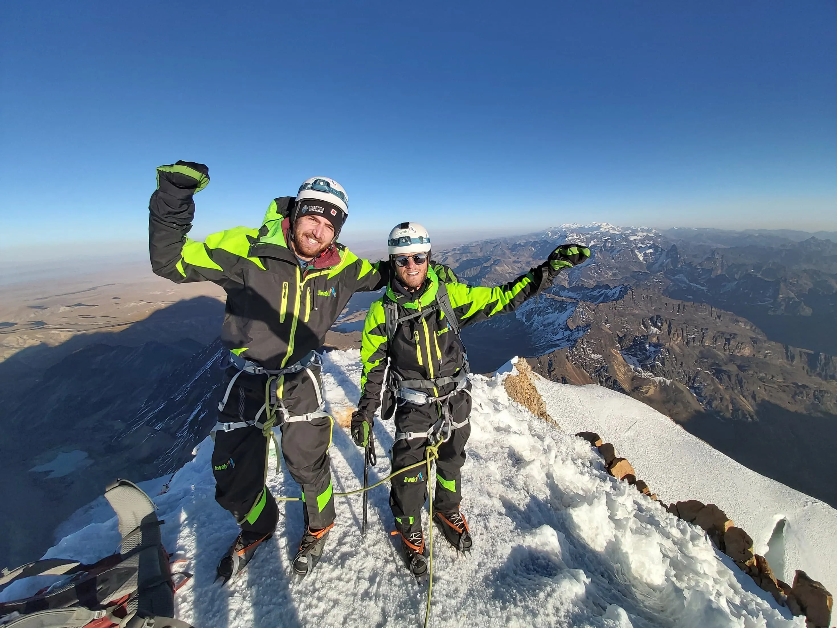
The Huayna Potosi Climb is the most popular climb in Bolivia and one of the busiest trails on the cordillera Real mountain range. This impressive massif has been conquered by basically all its faces. The first ones to reach the top were 2 Germans, R. Dients and O. Lohse, in 1919, after a failed attempt 21 years earlier, when all members of the group perished on the way to the summit. If you want to conquer this massif like R. Dients and O. Lohse, this article is for you. In this long read, you will find all the information about climbing Huayna Potosí, from the difficulty and weather to the deaths and how to combine Condodiriri and Huayna Potosi in one climb. Let's go!

Huayna Potosí is the closest high mountain to La Paz, in Bolivia. The name of this massif is in Aymara, a native language of the region, and it means "young mountain". Huayna Potosí is one of the city's most distinctive features. Huayna Potosí can be easily accessed by car from La Paz. Moreover, since La Paz is already at 3640 m, climbers have an easier time acclimatizing. This impressive massif is usually considered the "easiest 6000er in the world", but this climb should not be taken lightly: rocky terrain, snow, ice, and glacier fractures are characteristic features of this breathtaking beast!

Where is Huayna Potosí?

Huayna Potosí, 6,088 m / 19,974 ft, is an emblematic mountain that is part of a bigger mountain range, the Cordillera Real, in Bolivia. This huge and impressive massif is located on the western side of the country, close to the Bolivia's border with Peru, and is one of the icons of the city of La Paz, one of Bolivia's main cities.

Book Now

Huayna Potosí - Difficulty

Although Huayna Potosí is usually deemed as the easiest climb over 6,000 meters / 19,685 feet, it should not be taken lightly. Huayna Potosí can be climbed by complete beginners, that is true. It is also true that it is a great way to get ready for higher mountains, but you need to be ready for it.

If Huayna Potosí is in your plans, then start training a few months in advance. Trek a few hours a day, climb stairs, train with a backpack, and if you can trek in the mountains, that is even better. Get to your trek as fit as you can. That will raise your chances of making it to the top, as well as making the whole journey more enjoyable.

Do make sure you're properly acclimatized as this trek starts at very high altitude. Spend at least three nights in La Paz with one or two trips above 4000 meters. That will decrease the risk of altitude sickness.

Huayna Potosí - Difficulty

Best Season and Weather at Huayna Potosi, Bolivia

If you are planning your Huayna Potosí ascent, you must choose your dates carefully, especially if this is the first time you will be climbing at high altitude. The best months for trekking in the Cordillera Real mountain range are from April to November. During these months it rains the least and the skies are clearer. However, you must know that during these months, days are shorter, and temperatures can get as low as -20°C. During the rest of the year, temperatures are warmer, that is true, but rainfall is quite abundant, and winds tend to blow stronger.

Best Season and Weather at Huayna Potosi, Bolivia

Accommodation during Huayna Potosí trek

During the climb, you will spend your night at the Huayna Potosí refuges: Base Camp and High Camp, at 5,200 meters / 17,060 feet. From the High Camp refuge, you can see the summit and other peaks of the Cordillera Real. The Refuges are simple in nature but strong enough to keep you safe and warm during the night. You will spend the night in dormitory rooms with bunk beds. There can sleep 10 or more people in each room. Bear in mind that you will have to bring your own sleeping bag.

Accommodation during Huayna Potosí trek

Climbing Huayna Potosí - Trekking Itinerary

The Huayna Potosí climb is an exciting 6000 m summit that can be climbed by complete beginners and provides amazing views of the Cordillera Real, Lake Titicaca (3810m), and the Altiplano (4000m). Here is a 3-day itinerary provided by one of our partners in Bolivia, Climbing South America.

Day
1

La Paz – Paso Zongo

We drive from La Paz to Paso Zongo (4700m). Once at Paso Zongo we drop our gear off in the hut and have some lunch. After lunch, we walk to the lower glacier, at the lower glacier the guides will explain and show some basic techniques for ice climbing and mountaineering. We will have the chance to practice these techniques with the guides and our climbing equipment. Later in the day, we will practice ice climbing techniques on small ice walls with safety ropes in place. After we walk back to the base camp where we sleep in a Refugio.

Drive: 1 ½ hour drive

Walking time: 2 hours trekking

Accommodation: Refugio

Paso Zongo

Info
Paso Zongo
Day
2

Paso Zongo – High camp (5150m)

Today we have a relatively easy day up to high camp. High camp is on a rock buttress at an altitude of 5200m and at the base of the glacier. The walk up in on a well used path on rock. Once at high camp, we need to get our gear ready for the next day, as we have an early start in the morning. We also have time to rest and rehydrate. It’s an early night tonight where we sleep in the Refugio.

Walking time: 2 - 4 hours trekking

Accommodation: Refugio

High Camp

Info
High Camp
Day
3

High camp – Summit (6088m) – High camp - La Paz (3600m)

We have an early start in the morning. We will leave around 1 am in the morning. It will be cold so we want to dress well. The climb starts on the glacier, so will start with our crampons on, and the rest of our climbing gear. The climb mostly follows a trail on the glacier. We have 2 steep sections, one at around 5600m, called the Pala Chica. The trail goes through a snow and ice wall. Once through this part, we keep following the trail on the glacier up to 6000m. From this point, we can see the summit above as. The last section to the summit is great climbing on an exposed ridge. From the summit, we can see from Illimani (6439m) to Illampu (6368m). After we take our photo shot on top, we head back down the same way to high camp. Once back at high camp we have a short rest and pack our gear. We then head back down to base camp to meet our transport back to La Paz.

Walking time: 9 - 13 hours climbing

Drive: 1-hour drive

Condoriri to Huayna Potosí - Combined Itinerary

The snow-capped Condoriri Massif is a breathtaking mountain located within the Cordillera Real Mountain Range. Just like Huayna Potosi, the Condoriri massif stands close to La Paz, to the north-east of Huayna Potosi, and goes as high as 5.648 above sea level. Many trekkers choose to combine both peaks in one trek since they are relatively close and the Condodiriri is a nice warm-up before the trek to the summit of Huayna Potosi. Below is the itinerary operated by our Bolivian partner, Jiwaki:

Day
1

La Paz to Condoriri - Pico Austria - Base Camp of Condoriri

We will pick you up from your hotel at 8:00 am and we will drive for around 3 hours out of the city and through the Andean highlands until we reach Rinconada (4500 meters) from where we start the trek.

After an hour of gentle uphill trekking past several small lakes, we arrive at the larger lake of Chiar Khota (4700 meters). From there we begin the steeper ascent of Pico Austria (5350 meters) for around an additional 3 hours until we reach the summit.

From the top of Pico Austria, we have a spectacular view of Mt. Condoriri, with its shape of a Condor with its wings spread wide, Lake Titicaca, the west face of Huayna Potosi, and numerous other peaks of the Cordillera Real. Our descent to Chiar Khota will take around 1 hour.

We will spend the night at Chiar Khota.

Condoriri Base Camp

Info
Condoriri Base Camp
Day
2

Base Camp of Condoriri to Cerro Maria LLoko

We will breakfast by the lakeside and break camp before beginning our trek to Maria Llocko. During our trek, we will cross over two passes, the first with an elevation of 5000 meters and the second with an elevation of 4900 meters. Along the way, we will observe the typical fauna and vegetation of the high altiplano.

After around 7 hours of trekking, we will arrive at our second camp, Maria Llocko (4700 meters). Maria Llocko is a scenic spot at the base of the mighty west face of Huayna Potosi and is where we will make our camp for the second night.

Cerro Maria LLoco

Info
Cerro Maria LLoco
Day
3

Cerro Maria LLoko to the Base camp of Huayna Potosi and an afternoon instruction and practice.

Today our 4-hour trek will take us from the west side of Huayna Potosi and over a pass of 5100 meters. After crossing over into the next valley, we will arrive to the base camp of Huayna Potosi (4700 meters).

We will have lunch at the base camp lodge and then walk 40 minutes to the base of the Old Glacier where we will practice basic mountaineering techniques and ice climbing. Later we will return to the base camp for dinner and overnight lodging.

Base Camp of Huayna Potosi

Info
Base Camp of Huayna Potosi
Day
4

Ascent from Base Camp to High Camp

Breakfast at 8:00 AM consisting of fruit salad, milk, butter, jam, bread, and various hot drink options.

We will have lunch at the base camp, pack our backpacks with all of our technical climbing equipment and personal items, and then hike for 2 hours to our high camp, located at 5170 meters. Upon arrival at our high camp, we will have hot drinks, snacks, and dinner and go to bed around 6:00 PM.

High Camp

Info
High Camp
Day
5

Summit atemp and return to La Paz City

Our day will begin very early. Wake up time will be around midnight and we will get dressed with the climbing clothing and equipment and have breakfast.

Around 1:00 AM we will begin the ascent. We will have short breaks to rest and eat chocolates and drink water during the ascent.

We plan to arrive at the summit around sunrise in order to appreciate the wonderful view of the highlands, the surrounding Cordillera Real, Lake Titicaca, and the ever unique sunrise itself.

Our descent to high camp will take 2 – 3 hours and upon arrival, we will have vegetable soup and hot drinks. At the high camp we will re-pack our backpacks and make the 1-hour descent to base camp.

We usually arrive at our office in La Paz around 1:00 PM.

Hide entire itinerary

How dangerous is climbing Huayna Potosí?

Is Huayna Potosí that dangerous? No, not really. Of course, all high mountains can be dangerous if the weather turns bad, but the climb is straight forward, the trails are not particularly steep, and no technical experience is required. There have been many deaths over the years by climbers attempting to summit. However, nowadays, incidents are uncommon. The most important thing is attempting the summit accompanied by an experienced guide, especially if you are an inexperienced high-altitude alpine climber yourself.

Not sure yet or want to discuss your plans for the Huayna Potosi climb with one of our trekking experts? Get in touch today and turn your dreams into memories!

Huayna Potosí Packing List

Despite being considered the easiest climb over 6000 m, Huayna Potosi is quite a challenge. Having the right equipment with you is paramount in order to reach the summit successfully. Never underestimate the weather at such altitudes and be ready for snow and ice. Make sure that your equipment is suitable for temperatures below freezing temperature, especially your trekking boots, jacket and sleeping bag. We have prepared a suggested equipment list for you to help you to get ready for your Huayna Potosi adventure:

Essential equipment

  • Sleeping bag (rated to – 5 º C)
  • Headlamp
  • Backpack (minimum 50 L capacity)
  • Trekking boots
  • Trekking pants or leggings
  • Fleece jacket / Down jacket
  • Thermal clothing
  • 3 pairs of socks (at least one thick pair)
  • Snacks for the summit attempt
  • Sunglasses
  • Sunblock
  • 2 liters of water
  • Personal medication
  • Gloves
  • Beanie / Woolen hat
  • Toilet paper
  • Personal items

Tipping Guide and Porters after Huayna Potosí Trek

Tipping your guide and porters after the trek is not customary in Bolivia, however, it is always appreciated. There is no rule as to how much you should tip your crew, but USD 10-15 for each, per trekker, is what the trekking companies suggest. Mind that what might be just a small contribution for you can make a huge difference for your guide, porters, and their family. If you had a nice adventure with them, try to be generous.

How To Identify and Prevent AMS On The Huayna Potosi climb?

It's essential to understand that altitude sickness can affect anyone, regardless of age, fitness level, or previous high-altitude experience. These days there are several tools to monitor your health at altitude. A widely-used (analog) method is the Lake Louise score card. It ticks the altitude symptoms while keeping the severity in mind. It’s a common tool used by guides. Nowadays, most trekking and mountain guides bring a blood oxygen saturation meter, which also measures the heart rate. These are key indicators whether a person adapts to altitude well or not. AMS can occur when trekking the Huayna Potosi climb. Below you can find everything you need to know about altitude sickness.

  • Acute Mountain Sickness (AMS)

    Altitude sickness, also known as Acute Mountain Sickness (AMS) is a health condition that occurs when someone is exposed to low levels of oxygen at higher altitudes. AMS is a serious condition and as the name suggests acute. It needs to be dealt with immediately, as it is potentially life-threatening. Most people will experience some mild symptoms of altitude sickness. It’s important to be aware of these symptoms and act before symptoms become more severe. Below we break down the different forms of AMS and how you can reduce the risk of getting it.

    AMS symptoms

    It is key to know how to identify altitude illness. You may experience the following symptoms due to the jump in altitude: headache, lack of appetite, breathing difficulties, insomnia, nausea and vomiting. The intensity and severity of these symptoms may increase with altitude and an overall feeling of fatigue will take all your joy away. This may further deteriorate to one of these life-threatening conditions.

    High Altitude Pulmonary Edema (HAPE): HAPE is a condition in which fluid accumulates in the lungs, making it difficult to breathe. Symptoms may include shortness of breath, a persistent cough, chest tightness, and an increased heart rate. It can be a life-threatening condition and requires immediate descent to lower altitudes and, in severe cases, medical treatment.

    High Altitude Cerebral Edema (HACE): HACE is a more serious condition in which fluid accumulates in the brain. Symptoms may include severe headaches, confusion, loss of coordination, and altered mental status. HACE is also a medical emergency and requires immediate descent and medical attention. Below 7 ways of minimizing the risk of AMS:

    • 1. Gradual Ascent

      One of the most effective ways to prevent AMS is to ascend gradually. When traveling to high altitudes, try to take several days to acclimatize before going higher. This allows your body to adapt to the reduced oxygen levels. All our treks in Nepal keep sufficient acclimatization into account.

    • 2. Stay Hydrated

      Dehydration can increase the risk of AMS, so drink plenty of fluids. Avoid excessive alcohol and caffeine consumption, as they can contribute to dehydration.

    • 3. Diet

      Consume a balanced diet with adequate carbohydrates and avoid heavy, fatty meals. Carbohydrates can help your body utilize oxygen more efficiently at high altitudes.

    • 4. Medication

      Some individuals may consider taking medication, such as acetazolamide (Diamox), to help prevent AMS. Consult with a healthcare professional before using any medication, and be aware of potential side effects.

    • 5. Rest

      Ensure you get enough sleep and rest during your ascent. Fatigue can increase the risk of AMS.

    • 6. Avoid Overexertion

      Pace yourself and avoid overexertion. Listen to your body, and if you experience symptoms of AMS, rest or descend to a lower altitude.

    • 7. Descend if Symptoms Persist

      If you experience symptoms of AMS, such as headache, nausea, dizziness, or difficulty breathing, it's crucial to descend to a lower altitude. Symptoms should not be ignored or dismissed.

Where Can I Book the Huayna Potosi climb?

At Bookatrekking.com you can book this trek and many others. Our guided options come with experts on the ground, and offer you a convenient, stress-free, safe, and educational way to explore the outdoors. Find our offers here. Our easy-to-use platform allows you to browse and compare different trekking options and find the perfect fit for your interests, abilities, and budget.

If you have any questions about a specific trek or need help choosing the right one for you, our team of trekking experts is here to assist you. Simply reach out to us and we will be happy to provide you with personalized recommendations and advice to help you plan the trekking adventure of a lifetime.

Is this not your cup of tea and are you looking for other epic adventures? Check out one of our blog posts:

Comments

About Us

At Bookatrekking.com, you will find the trek that will make your life unforgettable. Whether you want to explore the Inca Trail or climb Kilimanjaro. Bookatrekking.com has a wide and varied range of first-class treks. No false promises are made here. Transparent prices and bookings are fixed instantly. Find, compare, book and trek!
Read more about us
About Us

Also Interesting

Show more